Lake Naivasha Flooding Hits Hotels And Safaris
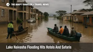
Lake Naivasha flooding tourism is no longer a distant climate story but a direct operational problem for December 2025 trips. Weeks of intense short rains have pushed the lake far inland, flooding Kihoto estate and other low lying neighborhoods on the Naivasha shoreline, and displacing between about 4,000 families and 7,000 people according to county and media estimates. Homes, schools, churches and access roads that also serve lakefront hotels, camps and curio stalls now sit in stagnant or slowly moving water, while tourist boats that normally carry birders and weekenders are ferrying residents out of waist deep streets. For travelers, that means Naivasha segments in Kenyan itineraries suddenly come with higher odds of broken road links, rerouted game drives and last minute lodge changes.
The core shift is that Lake Naivasha flooding tourism now describes a live mobility and accommodation risk rather than background environmental stress. Local reporting from Nakuru County and international wires describe floodwaters advancing up to 1.5 kilometres inland in parts of Kihoto, swamping multi storey residential blocks, churches and a police post, and submerging hotel plots and estate roads that sit close to the current shoreline. County disaster officials say that several thousand residents have been evacuated by truck and boat, while similar numbers remain in partially flooded homes as they wait for relocation support or fear losing their last assets.
Background: A Long Rising Lake Meets Short Rains
Lake Naivasha sits in Kenya's Rift Valley, roughly 90 kilometres northwest of Nairobi, and acts as a hub for weekend breaks, birding trips and safari routing between Nairobi, Hell s Gate National Park and Lake Nakuru National Park. Studies and local accounts say the lake has been rising for more than a decade, with repeated episodes of bank overtopping since around 2020, but the current short rains have accelerated the process and pushed water further into settled areas than many residents remember. County officials now describe whole stretches of Kihoto as fully submerged, while climate and engineering analysis notes that cultivated catchments and hardened surfaces can push more rainwater into the basin when storms hit.
Kenya Meteorological Department outlooks and weekly forecasts add another piece to the travel puzzle. Seasonal guidance for the October to December 2025 short rains suggests that western parts of Kenya, including the Highlands west of the Rift Valley, could see near to above average rainfall, while seven day and media based updates through November warn that showers and thunderstorms over the Rift Valley, Lake Victoria Basin and adjacent highlands are likely to continue into early December. In practical terms, travelers should assume that water levels and unpaved access roads around Naivasha will remain unstable for at least the first half of the month, even if skies clear intermittently.
Which Areas Around Naivasha Are Most Affected
The highest concentration of damage is on the south and southeast fringes of Lake Naivasha, especially Kihoto estate and adjoining parts of Lakeview ward, where photographs and video show residents propelling makeshift rafts down former streets and boats passing close to upper floor balconies. Local civic groups and reporters also point to impacts in Karagita and other shoreline settlements where hotels, guesthouses and small businesses sit on low ground near landing beaches or feeder streams, although exact property by property status can change week by week as water levels shift.
Beyond homes and guesthouses, rising water has reached pieces of critical infrastructure. Standard Media reports that a fuel pipeline running through the wider estate is now underwater, prompting questions about corrosion risk, and that a wildlife research center in Naivasha has been forced to close because its buildings and access ways are flooded. Conservation voices also warn that hippos displaced by the changing shoreline are grazing deeper into residential and farm plots, raising the odds of dangerous encounters on paths that used to feel routine.
For mainstream tourism, this combination means that budget and mid range lakeside properties in the Kihoto and Karagita belt face the greatest operational strain, while higher elevation lodges on escarpments or private conservancies above the lake line are more likely to remain accessible and physically dry but still contend with staff displacement and supply chain delays. Visitors booked into specific camps should not assume that a Naivasha address guarantees normal operations; they need direct, recent confirmation from operators.
Road Access And Routing Implications
Most coverage suggests that trunk tarmac corridors in and out of Naivasha, including the Nairobi to Nakuru highway, remain open, though heavy rain can slow traffic and cause ponding on shoulders. The bigger problems appear on estate and frontage roads that track close to the water, where sections have become canals and others turn into deep ruts once floodwaters recede slightly. For self drivers in rental vehicles, this raises non trivial risks of getting stuck, damaging undercarriages or finding that the last kilometre to a hotel gate is simply impassable.
Tour operators with high clearance vehicles and local scouts are better placed to adapt, for example by approaching surviving jetties from alternative tracks, switching to boat transfers for the last stretch or shifting guests to sister properties on safer ground. Even so, itineraries that hinge on same day moves between Nairobi, a Naivasha overnight and onward early departures to Maasai Mara airstrips or onward domestic flights in Nairobi become more fragile, because a single washed out track can cascade into missed flights or truncated game drives.
Travelers who were treating Naivasha as a soft landing between long haul flights and deeper safari segments should now reframe it as a variable risk component. In some cases, a cleaner option will be to add extra nights in Nairobi or to focus on higher ground hubs like Nakuru, then visit Naivasha as a tightly planned day trip if local conditions and operators confirm it is feasible.
Health, Safety And Community Context
The same standing water that has turned parts of Kihoto into a network of lagoons also concentrates sanitation and health risks. Local officials and news outlets describe flooded latrines, overflowing toilets and pools of stagnant water that raise concerns about cholera and other waterborne disease, and some flower farm workers who support Naivasha s export horticulture sector have reportedly stayed away from work for fear of contamination and landslides.
From a visitor perspective, that mix calls for basic but disciplined precautions. Travelers should avoid wading through floodwater even when it seems shallow, should treat cuts and bites carefully and should rely on bottled or appropriately treated water in affected areas. Hippo activity near flooded estates is another serious consideration; lodges that are still operating will usually offer escorted walks after dark or set clear red lines on where guests can move unaccompanied, and those instructions matter more than usual while grazing patterns are disrupted.
There is also a social dimension. Thousands of Naivasha residents are living in temporary shelters or in the upper floors of compromised buildings while they wait for promised relocation or compensation schemes, and national and county level debates over who pays and who qualifies are still live. Responsible travelers and operators will factor in that this is an active humanitarian emergency, not just an inconvenience to holiday plans, and should avoid putting pressure on already stretched local services.
Planning December 2025 Itineraries Around Naivasha
For travelers with upcoming trips that include Lake Naivasha, the practical choices break into a few categories. Those booked into lakeshore properties in obviously affected estates should push for very current, photographic proof of access and service levels, not just generic reassurances, and should be ready to rebook to higher ground lodges or to alternative hubs such as Nakuru if conditions look marginal. Those building new itineraries for December 2025 or early 2026 might treat Naivasha as optional, focusing instead on more resilient combinations like Nairobi plus Maasai Mara and one additional park, then revisiting Naivasha once water levels and resettlement plans stabilize.
Travelers who keep Naivasha segments should add slack wherever it fits, for example avoiding back to back one night stops, building at least one buffer day between Naivasha and fixed date activities such as international flights or pre paid gorilla permits in neighboring countries, and separating independent tickets by four to six hours when Naivasha is part of the routing. Guides on handling regional flood disruption, such as broader pieces on how monsoon and storm driven flooding affect travel planning, can provide useful templates even if they focus on different geographies.
Finally, Naivasha travelers should monitor Kenyan and local media for updates as the short rains tail off. If forecasts shift toward drier weeks and county authorities manage orderly relocations, access may gradually normalize, even if some hotels and camps near the waterline require months of repairs. Until then, treating Lake Naivasha flooding tourism as a live operational constraint, not a footnote, will help avoid trips that strand visitors between submerged estates and overbooked alternative hubs.
Sources
- Number of families displaced by Lake Naivasha shoots up
- Thousands of Kenyans displaced by Lake Naivasha flooding
- Lake Naivasha floods displace 7000 in Kenya's Rift Valley
- Lake Naivasha's rising waters submerge fuel pipeline, threaten power station
- Submerged dreams: Flooded Lake Naivasha puts tourism and livelihoods at risk
- Kenyan lake flood displaces thousands, ruins homes and schools
- Kenya Met Lists Central Kenya And Western Among Regions To Receive Rains This Week
- Seven day forecast 4 to 10 November 2025