Brazil Summer Storms Disrupt Flights And Landslide Routes
Brazil summer storms flights and overland routes are under pressure as a band of severe thunderstorms brings up to 100 millimeters of rain to at least ten states between November 30 and December 2, 2025. The National Institute of Meteorology, Inmet, has issued an orange level severe weather alert for parts of Amazonas, Maranhão, Mato Grosso, Pará, Paraná, Rio Grande do Sul, Rondônia, Roraima, Santa Catarina, and Tocantins, warning of intense rain, strong winds, and hail. For travelers, that combination means a higher chance that short haul flights, overnight buses, and self drive trips will face cancellations, diversions, or landslide driven roadblocks, so plans over the next several days need more buffer and backup options.
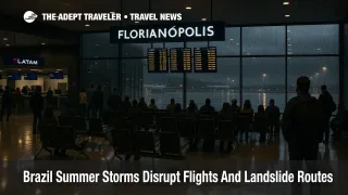
In practical terms, the Brazil summer storms flights alert translates into widespread but uneven disruption across a huge area, with airports such as Florianópolis-Hercílio Luz International Airport (FLN) and Porto Alegre-Salgado Filho International Airport (POA) cycling through runway closures and schedule gaps while mountain highways and river valleys see rising flood and landslide risk.
How The Storms Are Disrupting Flights
By midday on December 2, 2025, airport operator Infraero had logged more than 60 cancellations and about 90 delays nationwide, a sharp spike for a weekday shoulder period at the start of the summer holiday build up. Much of the impact has hit domestic networks and short haul connectors, since Brazilian carriers rely heavily on tight rotations between regional cities and the main hubs. The combination of waterlogged runways, repeated go arounds, and temporary air traffic control restrictions has forced operators to scrap whole rotations rather than risk aircraft and crews stranding out of position late in the day.
Secondary hubs have absorbed an outsized share of the pain. At Florianópolis-Hercílio Luz International Airport (FLN), ground teams twice closed the runway to clear standing water, while Porto Alegre-Salgado Filho International Airport (POA) paused departures when wind shear crossed safety thresholds, pushing knock on delays into the wider network. Earlier in the week, São Paulo's city centre Congonhas Airport (CGH) was still normalising after more than 115 weather related cancellations tied to a separate wave of storms on November 28 and 29, underscoring how quickly heavy rain can erode capacity even before the current alert window.
Flag carriers Latam and Azul have responded by opening limited fee free rebooking windows. Current policies generally allow passengers booked to travel through December 4, 2025, to change flights once without a change fee, provided the origin, destination, and cabin remain the same, and the new date falls within a defined range. However, fare differences can still apply, and inventory on remaining flights is already tight, especially on trunk routes from São Paulo, Rio de Janeiro, Brasília, and southern cities funneling traffic to the coast. Gol has taken a case by case approach, granting voluntary changes on some impacted routes, but not publishing as broad a formal waiver as its rivals.
Brazil does not apply European Union style EU261 compensation rules to weather events, and regulators treat severe storms as force majeure, which means airlines owe rebooking or refunds per their own policies but not cash payouts. Travelers who assume otherwise risk wasting time in airport queues arguing for compensation that is not available, instead of using scarce seats while they exist.
Landslides, Flooding, And Overland Travel
The same storms that are soaking runways are also chewing up roads. Federal highway police have already reported partial closures on BR 470 in Santa Catarina after flash flood damage to a bridge deck, a critical warning sign in a state where mountain highways and river valleys are the only links between interior towns and coastal resorts. Local civil defence units in Porto Alegre have asked residents to avoid low lying neighborhoods prone to landslides and flash floods, while repair teams race to keep up with new damage as each storm cell passes.
Inter city bus services are also adjusting. At least one major operator, Viação Garcia, suspended overnight runs on the Curitiba to Foz do Iguaçu corridor pending road inspections, citing safety concerns after heavy rain and strong winds. That kind of pause can cascade into missed same day connections for travelers who planned to arrive by bus and board a domestic flight or tour on the same morning. In Santa Catarina, a recent cyclone and severe storm sequence triggered hail, urban flooding, and temporary closures on BR 101 and BR 282, isolating some communities and showing how quickly a wet forecast can turn into impassable stretches of highway.
Brazilian and foreign advisories have been flagging these compound risks for weeks. A November 7, 2025, weather alert from the United States Embassy warned that a severe storm system could affect large areas of the country with heavy rain, flooding, and landslides, and Brazil's national disaster monitoring agency Cemaden has highlighted the potential for flash floods and mass movements, including road blocking slides, across multiple southern and southeastern regions when accumulations build quickly. For travelers, that means even well paved, familiar routes can be suddenly cut, particularly in steep terrain, urban hillside neighborhoods, and river crossings.
Where The Risk Is Highest Over The Next Few Days
Inmet's current orange level alert covers portions of Amazonas, Maranhão, Mato Grosso, Pará, Paraná, Rio Grande do Sul, Rondônia, Roraima, Santa Catarina, and Tocantins between November 30 and December 2, 2025, with forecasts calling for up to 100 millimeters of rain in 24 hours, gusts around 100 kilometers per hour, and isolated hail. While the precise polygons will shift as the system moves, the message is clear: central, northern, and southern belts of Brazil are all exposed at various points in the current window.
Inmet's broader December outlook reinforces the pattern. Meteorological projections point to above average rainfall in much of the North and parts of central Brazil, including Amazonas, Tocantins, Pará, and Amapá, with some areas potentially exceeding normal monthly accumulations by up to 150 millimeters, while parts of the South may trend slightly drier overall but still see intense short duration events. That means this first major storm belt of the summer is unlikely to be the last, even if the current orange alert is scaled back after December 2 or 3.
Travelers whose itineraries touch Porto Alegre, Florianópolis, Curitiba, Foz do Iguaçu, or interior hubs in Paraná and Santa Catarina should treat landslide and road washout risk as a serious factor, not a fringe concern. River valleys and steep approaches into the Serra Gaúcha and Serra do Mar have recent histories of slides, washed out bridges, and temporary highway closures under heavy rain, and the current pattern is already producing similar warning signs.
Practical Tactics For Brazil Itineraries During The Storms
For flyers, the most important move is to rebuild slack into domestic connections. Travelers connecting through São Paulo, Rio de Janeiro, Brasília, Belo Horizonte, or Porto Alegre should aim for at least three hours between flights, especially when mixing a regional feeder with a long haul departure. Separate tickets are strongly discouraged during this period, because a late inbound sector will not obligate the onward airline to help if you miss your flight.
Where possible, choose flights earlier in the day so there is more recovery time if the first sector is delayed or canceled. If you are already booked in the ten affected states, use any Latam or Azul waiver to move travel inside the permitted window before seats disappear, and verify terms carefully, since changes usually must keep the same origin, destination, and cabin, and may still attract fare differences. Keep in mind that airlines are not required to offer cash compensation for weather related disruption in Brazil, so pressing for payouts at the airport is unlikely to succeed.
Overland travelers should adopt a similar mindset. Avoid planning overnight bus rides on mountainous or riverside corridors during the peak of the alert, and whenever possible shift longer segments into daylight hours, when you and drivers can better spot debris, washouts, or standing water. If you must move between interior cities and the coast during this period, build an extra night into the schedule in case BR 101, BR 282, BR 470, or connecting roads need to close for inspections or emergency works.
For coastal, cruise, and eco itineraries, the safest strategy is to avoid same day handoffs. Do not plan to arrive by morning flight or overnight bus and board a ship, river cruise, or multi day tour that afternoon, because storms, flooded roads, or localized power cuts can easily delay your inbound leg or your baggage even when the flight itself operates. Travelers with flexibility should consider pushing non essential trips in the affected states into later December or early 2026, when more is known about how the seasonal patterns are stabilizing.
Related Coverage And Planning Resources
For a deeper look at how weather volatility in other regions can destabilize tight connections, see our coverage of Fog Season Disruptions At Dubai And Sharjah Show How Fragile Gulf Hubs Can Be. For broader planning advice, our evergreen guide How Summer Storms Affect Flights In The Tropics walks through typical storm patterns, aircraft limitations, and practical buffer strategies when booking in shoulder and rainy seasons.
Sources
- Severe Storms Disrupt Travel Across 10 Brazilian States; Authorities Issue Orange Alert
- Brazil Has Orange Alert For Rain, Hail, And Storms In 20 States And The Federal District
- Alert AS, Inmet Official Warning Map
- Congonhas Airport Recovers After 115 Weather Cancellations, Highlights Need For CAT III Upgrade
- Panorama Climático Do Inmet Para Dezembro De 2025
- Weather Alert, Country Wide Weather Alert, U.S. Mission To Brazil, November 7, 2025
- Hercílio Luz International Airport
- Porto Alegre-Salgado Filho International Airport
- Tempestade Em SC, Granizo, Destruição E Caos No Estado