Australia Heatwave, Tasmania Bushfires Hit Travel
An Australia heatwave and Tasmania bushfires travel alert is emerging for the December 6 to 7 weekend, with December 4, 2025 forecasts already pushing highs toward the low 40s Celsius in parts of New South Wales and Western Australia. At the same time, bushfires in Tasmania near Glenlusk, Levendale, and the coastal community of Dolphin Sands have triggered emergency warnings, evacuations, and property losses. This combination of dangerous heat and active fire grounds means travelers need to rethink city breaks, self drive itineraries, and coastal escapes, shifting plans toward cooler hours, backup routes, and more flexible bookings.
In practical terms, the current Australia heatwave Tasmania bushfires travel pattern means a broad zone of the country will be under some form of heat, fire, or smoke stress through at least the December 6 to 7 weekend, making it a poor moment for tight overland connections and lightly planned outdoor trips.
How the heatwave is unfolding
Australia s Bureau of Meteorology (BoM) has issued severe and, in some districts, extreme heatwave warnings across parts of New South Wales, Western Australia, and the Northern Territory, with western Sydney, the Hunter region, and several inland areas forecast to approach or exceed 40 degrees Celsius by Saturday. Coverage from national and local outlets notes that the heat dome stretches roughly 4,000 kilometers from western inland regions toward the east coast, bringing daytime highs in the low to mid 40s Celsius and unusually hot nights that keep minimum temperatures elevated.
In New South Wales, the most intense heat is expected across parts of the South Coast, Illawarra, metropolitan Sydney, the Hunter, and the Southern Tablelands before a cooler change arrives late on December 7, 2025. Western Australia faces similar conditions in the Pilbara and Kimberley, while severe heat persists across Tiwi, Daly, and Gregory districts in the Northern Territory. Authorities are flagging elevated fire weather in several states as hot, dry northwesterly winds combine with low humidity to dry out vegetation.
Health agencies in New South Wales and other states are again stressing that extreme heat can be as dangerous as more visible hazards, especially for older adults, young children, pregnant travelers, people with chronic conditions, and anyone who is not acclimatized to Australian summer temperatures. Their guidance aligns around a few core points, stay in air conditioned spaces where possible, use fans and cool showers, avoid strenuous activity in the hottest hours, and check on vulnerable companions.
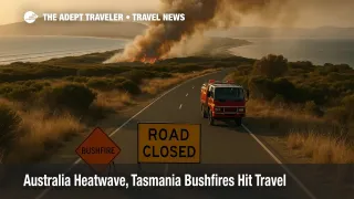
Tasmania s bushfires and coastal bottlenecks
While mainland cities worry about heat, Tasmania is already living through a fast moving bushfire emergency. Fires near Glenlusk, Levendale, and Dolphin Sands have surged under strong northwesterly winds, with Tasmanian media and Tasmania Fire Service (TFS) updates confirming that several homes have been lost around Dolphin Sands and that multiple communities have faced either emergency level or Prepare to Leave warnings over the last 24 hours.
Dolphin Sands is a narrow coastal strip with limited road access via Dolphin Sands Road, which means even small changes in fire behavior or wind can quickly cut the only practical escape route. Emergency warnings from TasAlert and ABC Emergency emphasize that embers, smoke, and ash can arrive well ahead of the main fire front and that late evacuation may be more dangerous than sheltering in a defendable structure. Travelers who are staying in holiday rentals, campgrounds, or small lodges in this area may not be as familiar with local fire plans as residents, which raises the risk that they underestimate how fast conditions can change.
Further inland, Levendale and surrounding districts north of Hobart have seen out of control fires under Watch and Act alerts, with crews focused on protecting homes and key roads while waiting for winds to ease and some moisture to arrive later in the week. Even where fire behavior has eased, smoke and ash can still degrade visibility, affect breathing, and create an unpleasant experience for visitors, especially on longer drives or outdoor excursions.
Parks, tracks, and reserves
Tasmania s Parks and Wildlife Service warns year round that tracks, campsites, and reserves may close at short notice when fire danger is high or when bushfires or planned burns are active nearby, and its alerts page has already logged closures and disruptions around high risk areas in recent weeks. Closures can include visitor centers, popular coastal lookouts, and full walking tracks, which means a traveler relying on a single marquee hike or viewpoint risks arriving to locked gates.
Similar logic now applies across parts of mainland Australia as well. In some states, parks and rural reserves will prohibit campfires outright on high or extreme fire danger days, and rangers may ask visitors to leave if wind, heat, or new ignition points change the risk profile. For itineraries built around hiking, wildlife spotting, or remote beach access, that means having at least one lower risk alternative, for example museums, food tours, or urban waterfronts, that does not depend on open tracks or forest roads.
City breaks under heat stress
The combination of severe heat and heavy summer demand will also stress city infrastructure in hubs like Sydney, Melbourne, Perth, Brisbane, and Darwin. Power grids can run close to capacity as households, hotels, and malls push air conditioning to the limit, and even short brownouts can be uncomfortable in budget accommodation with limited backup.
For urban travelers, the safest pattern on heatwave days is to front load or back load outdoor time. Plan harbor walks, short hikes, or open air markets for early morning, then spend the late morning through mid afternoon in air conditioned spaces such as major museums, shopping centers, or hotel lounges. Keep water handy, wear light clothing, and treat long, unsheltered walks between stations, bus stops, and attractions as real heat exposures, not trivial gaps.
Self drives, ferries, and onward connections
The current mix of heat and fire also changes the calculus for self drive itineraries and onward connections. On mainland routes, exposed stretches of highway that cross grassland or scrub can become high risk corridors if new fires start, and travelers may suddenly find themselves facing detours or short notice closures, especially in parts of New South Wales and South Australia that are under elevated fire danger ratings.
In Tasmania, the stakes are higher on peninsulas and coastal strips with only one road in and out, such as the approaches to Swansea, Coles Bay, and Dolphin Sands. If authorities advise against travel or signal that a route could close, travelers should treat that as a hard limit, not something to gamble on for the sake of a nonrefundable night. It is better to stay an extra night in Hobart or Launceston than to risk driving into a corridor that may be cut off by smoke or embers later in the day.
Same day links between ferries, regional flights, and long distance tours are also more fragile when fire or heat threaten roads. Travelers heading to or from Tasmanian ports and airports should build extra buffer into any overland leg and avoid separate tickets that leave no room for delays or rerouting.
Background, how Australian fire and heat warnings work
Australia now uses a national Fire Danger Rating System and the Australian Warning System to give consistent alerts about fire risk and active incidents. Ratings such as High, Extreme, and Catastrophic describe how difficult a fire would be to control, while warning levels like Advice, Watch and Act, and Emergency indicate what action people in the path should take. In Tasmania, TasAlert and ABC Emergency carry real time versions of these warnings, and tourism operators are encouraged to integrate them into their guest briefings and emergency plans.
Heatwave warnings from the Bureau of Meteorology are structured in a similar way, with categories such as Low Intensity, Severe, and Extreme that account for both daytime maxima and overnight minima, since hot nights reduce the body s ability to recover. For travelers, the takeaway is simple, treat both fire and heat warnings as operational constraints, not background noise.
How this fits into a wider pattern
This heat and fire episode is not happening in isolation. In recent weeks, Adept Traveler has tracked how summer storms in Brazil and early winter systems in the United States have produced sustained waves of flight delays and route changes, reinforcing the idea that weather and climate patterns now deserve the same planning attention as strikes or IT outages. Australia s emerging heatwave and Tasmania s bushfires slot into that same pattern, a structural risk that will recur, rather than a one off shock.
Travelers who adopt a more conservative playbook for the coming weekend, favoring flexible tickets, cooler hours, and routes with multiple escape options, will be better positioned to adapt if forecasts worsen or new fires start. Those habits will also serve future summers, when similar patterns are likely to repeat.
Sources
- Heatwave warning for large parts of Australia as temperatures expected to reach low 40s
- Heatwave warning, New South Wales, Bureau of Meteorology
- Extreme heatwave to sweep Australia as temperatures soar above 40C
- Bushfire threat as temps soar in several states
- Tasmania Fire Service urges Glenlusk, Dolphin Sands and Levendale residents to prepare for evacuation
- Bushfire Emergency Warning, Dolphin Sands, seek shelter now
- Alerts, Tasmania Parks and Wildlife Service
- Scorching heatwave to smother Sydney as hot air mass moves across NSW
- Scorching heat to cover 4000km of Australia this weekend
- Tasmania bushfires, multiple fires burning across south of the state