US Snowstorm Flight Cancellations December 8 2025
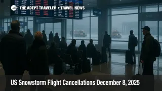
US snowstorm flight cancellations are piling up on December 8 2025 as a series of winter systems sweep across the Midwest, Great Lakes and parts of the South, cutting capacity at major hubs and rippling knock on delays into Florida and the West Coast. More than 879 flights have already been canceled and over 10,000 delayed across the United States, leaving passengers stuck in terminals from Chicago, Illinois and Detroit, Michigan to Dallas, Texas, Orlando and Miami, Florida, Los Angeles, California and Tampa, Florida.[1] Travelers on regional connectors and mainline services for Delta Air Lines, American Airlines, United Airlines and their affiliate carriers are especially exposed, with rolling crew and aircraft mispositioning likely to echo into the next several days. Anyone with tight domestic or transatlantic connections should be looking now at buffers, alternate routings and whether to move trips off the worst hit days.
The US snowstorm flight cancellations are clustering at big connection points such as Chicago O Hare International Airport (ORD), Hartsfield Jackson Atlanta International Airport (ATL), Orlando International Airport (MCO), Detroit Metro Wayne County Airport (DTW), Dallas Fort Worth International Airport (DFW), Miami International Airport (MIA), Tampa International Airport (TPA) and Los Angeles International Airport (LAX), forcing many travelers to rebook or accept longer layovers through midweek.[1]
Where Flight Disruptions Are Worst
FlightAware based tallies compiled by industry outlets show more than 879 cancellations and 10,037 delays for flights into, out of and within the United States as of December 8, with the heaviest concentrations in a handful of familiar large hubs.[1] Chicago O Hare is again a focal point, with around 180 to 190 departures or arrivals canceled and roughly three quarters of remaining flights delayed, reflecting both active snow and the way that O Hare sits at the crossroads of Midwest and coast to coast flows.[1]
Hartsfield Jackson in Atlanta is also seeing more than 100 cancellations and about 700 delays, a reminder that snow and ice in the Midwest still translate into downstream congestion when aircraft and crews cycle through southern hubs that may have clear skies but limited gate and runway capacity.[1] Orlando, Miami and Tampa in Florida, along with Dallas Fort Worth in Texas and Los Angeles International in California, are all posting double digit cancellation counts and triple digit delay numbers, not because of local blizzards, but because they sit at the end of spokes that originate in the storm belt.
Detroit Metro and Minneapolis St Paul International Airport (MSP) are feeling a more direct weather hit, with snow and winter weather advisories over Michigan, Wisconsin and Minnesota combining with de icing queues and intermittent visibility issues to slow departures and arrivals.[3] Smaller airports scattered across the Upper Midwest and northern Plains, including Pensacola International Airport (PNS) on the Gulf side and regional fields in Wisconsin and Iowa, are clocking unusually high cancellation percentages even when their absolute numbers are modest.[1][3]
On the airline side, Delta, American and United remain at the center of the disruption, but some of the highest cancellation percentages are showing up at their regional partners. Envoy, PSA, Republic, GoJet, Piedmont and other contract carriers that feed the big three networks are showing cancellation rates in the mid single to high single digits and delay rates north of one third, which magnifies the impact on passengers in secondary cities who rely on those feeders to connect into the long haul system.[1]
How The Current Winter Storm Pattern Is Evolving
The National Weather Service and related outlets report winter storm warnings, watches and advisories across a swath of states, including Alaska, Colorado, Illinois, Iowa, Wisconsin and Wyoming, with some mountain and lake effect zones forecast to see up to 16 to 20 inches of snow and winds approaching 50 to 65 miles per hour between December 7 and December 8.[3] The current pattern combines classic Alberta clipper systems sliding southeast from Canada with embedded low pressure centers tapping Gulf and Atlantic moisture, which means relatively fast moving but intense bursts of snow, rapidly changing visibility, and localized whiteout conditions especially in open country and near the Great Lakes.[2][3]
For aviation, this is less about dramatic airport closures and more about the cumulative effect of multiple short sharp snow bands passing through a network that is already running close to its capacity limits. Each burst of snow requires runway plowing, de icing and sometimes short ground stops while visibility improves, and when that is happening at several hubs at once the delay minutes compound. The Federal Aviation Administration, FAA, National Airspace System status page and operations plan advisories for December 8 highlight the potential for ground stops and delay programs at Chicago O Hare, Chicago Midway International Airport (MDW), Hartsfield Jackson and other major hubs as conditions evolve through the day.[4]
Background: Shutdown Era Flight Caps And Today's Disruptions
One reason this round of US snowstorm flight cancellations feels so sharp is timing. In mid November, the FAA began lifting shutdown era flight restrictions that had capped schedules at 40 major airports by as much as 6 percent after the nation's longest government shutdown and an associated squeeze on air traffic control staffing.[5][6] Airlines were allowed to resume normal schedules from November 16 once staffing metrics improved, a move that restored seat capacity but also removed a layer of slack that had been insulating the system from minor weather events.
With that buffer now gone, a mid December style winter pattern hitting Chicago, Detroit, Minneapolis and a string of smaller Upper Midwest airports is more likely to produce days like December 8, where delays show up not just in the snow zones but at the far ends of the network in Florida, Texas, California and the Northeast. The legacy of the shutdown period is still visible in the way that some terminal areas remain thinly staffed, which pushes the FAA to apply conservative spacing and traffic management initiatives when visibility and runway conditions deteriorate, even if the headline storm totals do not look extreme compared to historic blizzards.[5][6]
How Winter Storms Shut Down Flights
Winter storms disrupt flights in layers. The most immediate factor is runway condition. Active snowfall and blowing snow reduce friction and visibility, forcing airports to alternate between plowing and arrivals or departures, which cuts effective capacity even when the airport never formally closes. At the same time, every aircraft departing a snow affected gate requires de icing, which can add 15 to 40 minutes to turn times and may have to be repeated if a band of snow moves through after the first treatment.
On the air traffic control, ATC, side, low ceilings and reduced visibility often require more generous spacing between aircraft on approach, while crosswinds or gusty conditions may constrain which runways are usable. When multiple hubs are under some combination of winter weather and ATC restrictions, national level planners at the Air Traffic Control System Command Center lean on ground delay programs and occasional ground stops to keep airborne traffic from overwhelming saturated arrival banks. The net effect for travelers is that even flights departing clear cities can face long waits for gates, crews or connecting passengers when the arrival hub is struggling.
Practical Rebooking And Buffer Strategies
Given the scale of today's US snowstorm flight cancellations, the most important decision travelers can make is whether to avoid the storm period entirely. If your trip is discretionary and your airline issues a weather waiver for flights touching Chicago O Hare, Minneapolis St Paul, Detroit, Denver or other flagged airports, the lowest stress option is often to move your entire itinerary two or three days later while change fees are waived, even if that means shifting hotels and ground plans.
For trips that must operate, focus on reducing connection risk. If you are currently booked on a two leg itinerary with a 55 minute connection through a hub like O Hare, Atlanta, Dallas Fort Worth or Orlando over the next forty eight hours, treat that as a high risk routing. Where inventory allows, ask to move to an earlier first leg to extend your connection to at least two hours for domestic to domestic and three hours for domestic to transatlantic connections, or shift to a different hub that is outside the heaviest snow bands. Travelers ticketed on separate itineraries, for example one ticket to a hub and another onward to Europe, should assume that misconnect protection will be weak and strongly consider moving to a single ticket or adding an overnight.
If you are already at the airport, use multiple channels. Airline apps often display rebooking options before gate agents can process long queues, and many carriers still maintain call centers or chat channels that can handle changes while you stay in line as a backup. Keep an eye on aircraft assignment as well as flight number, since repeated inbound delays can sometimes be a better predictor of cancellation than the status line itself. When offered a choice between a later nonstop and an earlier connection that touches a snow affected hub, the nonstop usually has a better chance of operating.
Onward Travel, Driving And Hotels
Flight disruption at this scale quickly spills into ground transport and accommodation. In snow affected states, treat the drive to or from the airport as part of the risk envelope. Leave more time than usual, slow down well in advance of ramps and merges, and be realistic about whether a two airport transfer is wise if conditions are deteriorating. Many winter storm casualties occur not in the air but on icy interstates and local roads when travelers race to salvage tight connections.
For overnight stays, assume that airport hotels near the hardest hit hubs will sell out early. If your last flight of the night is showing repeated short delays or sits behind a line of aircraft waiting for de icing, it can be worth locking in a cancellable hotel near the airport before the airline formally cancels the flight. In cities where snow totals are heavy and temperatures are expected to plunge into the single digits or below zero Fahrenheit over the next several days, as some forecasts suggest for parts of the Midwest and Ohio Valley, make contingency plans for possible power outages that could affect both hotels and ground transport.[3]
What This Means For The Next Week
The pattern driving today's cancellations is unlikely to vanish after December 8. Meteorologists are flagging a sequence of clipper systems and reinforcing shots of Arctic air that will keep the threat of snow, freezing drizzle and low wind chills active across the northern tier states and into the Mid Atlantic through at least midweek, with another surge of Arctic air possible closer to the December 12 to 14 window.[2][3] Even if the worst of the snow moves east, the residual effects on crew positioning, aircraft maintenance cycles and passenger backlogs will take time to unwind.
For travelers, that means thinking beyond a single day. If you are booked later this week through the same hubs that are struggling today, check how many flights on your route typically operate each day and how fast they tend to fill. A 6 percent cut in available flights during the shutdown era was challenging but predictable; in a post cap environment, weather driven cancellations can remove a higher share of seats with very little warning, and the replacement seats may not appear for several days on constrained routes.[5][6] Building in flexible dates, refundable or changeable tickets and travel insurance that clearly covers weather and missed connections can help absorb some of that volatility.
Taken together, today's US snowstorm flight cancellations are a reminder that winter travel is as much about system design as it is about individual storms. When multiple hubs sit near capacity and winter weather hits several of them in sequence, the impact reaches passengers far from the snow line. Planning ahead, choosing routings with more resilience and being ready to move quickly when forecasts tighten can make the difference between a difficult travel day and a stranded weekend.
Sources
- [More Than 879 Flight Cancellations and 10,037 Delays Hit US as Republic, Spirit, Frontier, Envoy, PSA, Delta, and Others Face Widespread Travel Disruptions, Leaving Thousands of Passengers Grounded Across Detroit, Orlando, Dallas, Miami, Los Angeles, Tampa, and Beyond][1]
- [Winter Storm Warnings in the U S Check Top States at Risk, Safety Tips and Preparedness][3]
- [Alberta Clipper Prompts Winter Storm Watches in Minnesota, Wisconsin, North Dakota and Wyoming][2]
- [National Airspace System Status, Forecast Events and Programs for December 8 2025][4]
- [FAA Ends Shutdown Era Flight Limits as Air Traffic Staffing Improves][5]
- [FAA Says Flight Cuts Will Stay at 6 Percent Because More Air Traffic Controllers Are Coming To Work][6]