BC Storm Warning Tightens Travel On Mountain Highways
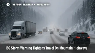
Canada's latest storm messaging has turned BC storm warning mountain highways travel plans into if then exercises for the next several days, as a strengthening Pacific system lines up heavy alpine snow, rain, and strong winds across British Columbia. Drivers on the Coquihalla between Hope and Merritt, on Highway 3 over Allison Pass, on the Okanagan Connector between Merritt and Kelowna, and on the Sea to Sky between Squamish and Whistler are now staring at forecasts of 20 to 40 centimetres of snow at higher elevations, reduced visibility, and the real potential for rolling closures or chain controls. Anyone connecting through Vancouver or relying on ferries and regional flights needs backup options, extra buffer time, and a realistic willingness to postpone non essential trips when advisories tighten.
What changed on December 9 is that a mix of Environment and Climate Change Canada (ECCC) highway snowfall warnings, BC River Forecast Centre high streamflow advisories, and provincial road messaging has shifted from a general Pacific Northwest atmospheric river outlook into explicit advice to avoid non essential travel on some of British Columbia's most important mountain corridors. Travel and Tour World pulls those pieces together and describes the pattern as an urgent travel warning for British Columbia, stressing risks to both highways and airports as the storm peaks.
Where The Warning Hits Hardest
On the roads, the sharpest edge sits on the Interior and coastal mountain passes that tie the Lower Mainland to the rest of the province. ECCC alerts highlight the Coquihalla Highway 5 between Hope and Merritt, the Okanagan Connector Highway 97C between Merritt and Kelowna, and Highway 3 from Hope to Princeton for periods of heavy snow, gusty winds, and near zero visibility, with forecast totals often in the 20 to 40 centimetre range over 24 to 36 hours at summit level. Previous Coquihalla warnings from Environment Canada show the same baseline language, asking drivers to consider postponing non essential travel until conditions improve when prolonged upslope flow and dropping snow levels combine.
The Sea to Sky Highway between West Vancouver, Squamish, and Whistler sees a different but related mix of hazards. Here the same storm delivers heavy rain or wet snow at lower elevations, heavier snow in the high points near Whistler, and strong winds funneling along Howe Sound. Short stretches of very poor visibility, debris on the road from falling branches, and localized rockfall are all familiar outcomes in similar systems. Drivers who are used to summer day trips along Howe Sound can find winter conditions surprisingly unforgiving if they push ahead when snow level dips to highway elevation.
Farther east, travel trade coverage and local news echo warnings for Highway 1 between Eagle Pass and Rogers Pass, where ECCC snowfall bulletins call for up to about 30 centimetres of snow in some bands, plus strong winds over exposed summits. This is not unusual for December, but the timing inside a wider atmospheric river pattern matters, because snow, wind, and rain can stack across multiple corridors at once instead of taking turns.
Coastal Flooding, Ferries, And Low Lying Roads
At lower elevations, the same moisture plume expresses as intense rain and high streamflow, especially along the South Coast, Vancouver Island, and the Sunshine Coast. BC's River Forecast Centre has high streamflow advisories in place for several of those regions, warning of rapid river rises, localized flooding, and debris flows as saturated slopes shed water into creeks and rivers. Local reporting around Greater Victoria already describes heavy rain episodes that have produced scattered power outages and wind gusts strong enough to bring down branches, a pattern that will likely repeat as more bands move through.
For ferry travelers, the risk is less about a single blanket shutdown and more about route specific cancellations and delays as winds climb toward BC Ferries safety thresholds. Official pages emphasize that sailings on exposed routes can be cancelled or held when gusts and waves exceed limits, and that customers should check travel advisories and real time "Current Conditions" before heading to terminals. At the time of writing, BC Ferries is mostly flagging potential weather disruption rather than a full slate of cancelled sailings, but the combination of high streamflow, saturated soils, and strong winds means travelers need a mental plan for same day ferry changes.
Low lying stretches of highway that cross floodplains or hug riverbanks, particularly in the Fraser Valley and around Metro Vancouver's outer suburbs, also bear watching. Pooling water, standing debris, and localized slides can close short segments without warning even when most of a route is fine, and recovery often depends on daylight for safe inspection.
Air Travel Through Vancouver And Interior Hubs
In the air, the first visible signal is a rise in delays and scattered cancellations at Vancouver International Airport (YVR) and other Canadian hubs as weather squeezes capacity. Recent flight data summarized by Travel And Tour World show dozens of delays and a handful of cancellations at YVR today, reflecting a mix of local weather and knock on disruption from storms and operational problems elsewhere in the country. Adept Traveler's own Canada flight disruption coverage has already flagged a messy national pattern, where winter systems, an Air Transat strike window, and airport specific issues are all pulling in the same unhelpful direction.
So far, Air Canada and WestJet have not posted a dedicated British Columbia winter storm waiver, instead steering customers to their standing travel alert and daily outlook tools. In practice, that means travelers should watch for the red "Travel Alert" icons and any route specific advisories, which can unlock fee free rebooking windows when conditions deteriorate. For itineraries that connect through Vancouver, Victoria, Kelowna, or smaller Interior airports, the safer assumption is that ground conditions around the airport and weather at other legs in the chain may be as important as the METAR at the departure gate.
Even where runways remain open, heavy rain, low cloud, and gusty crosswinds tend to lower arrival and departure rates, extend deicing queues, and increase the odds of missed connections. Flyers with tight same day links, especially those that depend on separate tickets or same day ferries and mountain drives, are at the highest risk.
How This Differs From The Earlier Atmospheric River Outlook
Yesterday's Adept Traveler piece on the Pacific Northwest atmospheric river treated the storm as a corridor wide problem from northern California through Washington, Oregon, and southern British Columbia, focusing on broad patterns of heavy rain, rising snow levels, and ferry and rail vulnerability. Today's upgrade for British Columbia adds a more concrete layer, where highway specific snowfall warnings, high streamflow advisories, and BC winter driving rules intersect.
Provincial winter driving guidance reminds motorists that most major BC highways cross high mountain passes, and that conditions can diverge sharply between valley floors and summit elevations. Winter tires or chains are mandatory on many of these routes from October through spring, and drivers are expected to carry warm clothing, food, and emergency supplies whenever they venture onto long, remote stretches. The new storm warnings do not create those rules, but they do mean that enforcement and closures are more likely, and that visitors without experience in snow and ice should think carefully before attempting ambitious road trips on tight schedules.
Roadside Reality, Closures, And Chain Checks
DriveBC's live map already shows the familiar mix of travel advisories, construction slowdowns, and weather related notifications, with update times pointing to a high level of attention from road operators as the storm pulses through. In past events with similar snowfall and wind forecasts, the Coquihalla, Highway 3, and the Okanagan Connector have all seen periods where convoys, temporary closures, or avalanche control work halted traffic for hours, and where official advice to avoid non essential travel proved more than just a suggestion.
Visitors used to urban motorways can underestimate how few alternate routes exist once a major mountain highway closes. Detours can add several hundred kilometres and push trips onto secondary roads that are narrower, less frequently plowed, or more exposed to slides. Combining that with early nightfall and the fatigue of long days at the wheel is a recipe for trouble.
How To Rebuild Plans Around The Storm
For self drive itineraries that cross between the coast and the Interior in the December 9 to 11 window, the most conservative move is to add at least one full buffer day on either side of planned high elevation crossings, then be willing to swap the order of stops to take advantage of any calm spells that emerge. Drawing on recent Yukon snowfall coverage, a good rule of thumb is to avoid scheduling critical commitments, such as cruise departures or long haul flights, within twenty four hours of a mountain pass leg in active warning periods.
If you must drive, aim to cross passes in mid to late morning, when road crews have had time to deal with overnight snow and daylight gives you better reaction time. Avoid night driving over summits when snowfall rates are highest, snowplows are rotating, and black ice is harder to see. Keep fuel tanks at least half full, keep phones charged, and load a proper winter kit into the vehicle, including warm layers, food, water, traction aids, and a shovel.
For Vancouver based city breaks and ski trips that mostly rely on flights, airport shuttles, and short transfers, the storm is more about delays and slower surface journeys than outright trip cancellations. Build extra time between flight arrivals and resort bus departures, assume airport parking and public transport will move more slowly, and think twice before locking in non refundable activities on the same day as long drives from YVR.
Anyone flying long haul into Vancouver with onward connections deeper into Canada should treat today's Canada wide disruption story as part of the same puzzle. Weather or strike impacts in Toronto, Montreal, or Atlantic Canada can still ripple into aircraft availability for western legs, and vice versa. As usual, single ticket itineraries booked directly with airlines offer the best protection, because carriers are then obligated to reroute or rebook when same day routing breaks down.
Finally, travelers who are not locked into fixed dates should consider simply sliding non essential trips outside the December 9 to 11 peak. This is a significant winter storm in a region built to handle such events, not an existential shutdown, but the gap between locals with snow tires and experience and visitors on tight schedules is exactly where avoidable accidents and misery tend to sit.
Sources
- [Canada Issues Urgent Travel Warning For British Columbia As Storm Set To Intensify, Travel And Tour World][1]
- [Pacific Northwest Atmospheric River To Disrupt Travel, The Adept Traveler][2]
- [High Streamflow Advisory, BC River Forecast Centre][3]
- [Winter Driving In BC, Government of British Columbia][4]
- [Travel Advisories And Current Conditions, BC Ferries][5]
- [Delays And Road Condition Advisories, DriveBC][6]
- [Canada Flight Delays At Major Hubs As Weather, Strike Loom, The Adept Traveler][7]
- [Heavy Rain And Power Outages On South Vancouver Island, Island Social Trends][8]