Storm Byron Israel Flooding Risk For December Trips
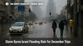
Storm Byron is now rolling directly toward Israel, turning this week s forecast into a clear Storm Byron Israel flooding risk rather than a distant European headline. Meteorologists expect 100 to 200 millimetres of rain between the night of Wednesday December 10 and Friday December 12, 2025, from Haifa and Tel Aviv to Jerusalem and the northern Negev, with desert wadis and Dead Sea roads under the highest flash flood concern. Travelers with December 10 to 12 itineraries need to treat desert hikes, self drive loops, and tight airport transfers as conditions to actively reschedule or pad.
In practical terms, the updated forecast means Storm Byron will dump extreme rain on Israel s coastal corridor and desert tourism zones between December 10 and 12, forcing travelers to shift desert legs, add time to transfers through Ben Gurion Airport (TLV), and avoid wadis and canyon hikes outright.
Updated Forecast For Israel
Israel s meteorological service and local outlets now converge on a picture of an intense, fast hitting storm that peaks late Wednesday into Thursday. Forecasts compiled by Ynet, Haaretz, and The Jerusalem Post suggest that many areas of central and northern Israel could see 100 to 150 millimetres of rain, with some models pushing up toward 200 millimetres in parts of the coastal plain and lowlands. The heaviest bursts are expected over just a few hours, which is what turns ordinary winter rain into urban flash flooding.
Rain bands are already brushing the country in advance of the core system, and the Israel Meteorological Service has flagged widespread heavy rain from the north through the Sharon and Gush Dan corridor, across Jerusalem and the Judean hills, and into the northern Negev. Strong winds of 80 to 100 kilometres per hour along exposed coasts and ridgelines add tree fall and power cuts to the risk mix, but authorities are focusing their warnings on drainage overload and flash floods rather than wind alone.
Critically, this Byron phase lands on already wet ground after earlier November and late November storms that pushed some basins near capacity. That history matters because drainage systems clogged by previous debris and elevated stream levels can fail more quickly when a new surge of water arrives.
Desert Routes And Wadi Hikes Most At Risk
The sharpest warnings now target the Judean Desert, the Dead Sea valleys, the Jordan Valley, and desert routes across the Negev and Arava that many travelers use for winter hiking and self drive road trips. Israel Nature and Parks Authority has gone as far as to state that entering stream channels in the Dead Sea streams, Judean Desert, and Jordan Valley is absolutely prohibited during the storm window, on foot or by vehicle, because of life threatening flash flood risk.
In practice, that translates into a do not go list for classic wadi hikes and slot canyons on December 10 to 12. Trips down desert ravines, guided or unguided, should be moved to another part of the itinerary, replaced with city days, or dropped entirely. A dry canyon can become a narrow chute of brown water and boulders in minutes, often from rain that fell many kilometres away, leaving no safe path of retreat.
For drivers, the weak points are the same places that made headlines when an earlier storm recently cut Eilat off from the rest of the country, with police closing Highways 12, 40, and 90 after intense rain turned segments into rivers and damaged infrastructure. That event, plus older tragedies in Negev and Dead Sea flood zones, is the template authorities have in mind as they warn against crossing dips and streambeds during Byron.
Any itinerary that places a long desert leg on Wednesday night, Thursday, or early Friday, especially on roads that cross wadis or low passes toward the Dead Sea and Eilat, is now a candidate for rescheduling. The safest pattern is to bring those drives forward into calmer conditions or to insert a buffer night in central Israel between desert and flight days rather than trying to thread a narrow weather gap.
Airport, Rail, And City Travel Expectations
As of December 9 there is no indication that Ben Gurion Airport will pre emptively close for Storm Byron. Israel s main hub has ridden out many strong winter systems while keeping runways open, and authorities typically only halt operations for security threats or direct safety issues. The vulnerability instead sits in the roads, junctions, and rail lines that feed the airport and connect it with Tel Aviv, Jerusalem, and other cities.
In previous heavy rain events, parts of the Ayalon basin, Namir Road, Rokach Boulevard, and underpasses on arterial highways have flooded badly enough for police to block lanes or close stretches altogether. Drainage failures like that can easily add an hour or more to a drive to Ben Gurion, even when flights are operating broadly on time. If Byron delivers the forecast 100 millimetres or more in a day over Gush Dan, a repeat of those bottlenecks is a realistic scenario.
Israel Railways is also vulnerable to ponding and landslides where tracks run near embankments, bridges, or cuttings. During strong winter storms, it has occasionally slowed or suspended services until inspections clear the lines. With Byron lining up squarely over core rail corridors that link Haifa, Tel Aviv, Ben Gurion, and Jerusalem, travelers should treat train timetables as provisional for the peak period and avoid planning razor thin rail to flight or rail to tour connections.
Ramon Airport (ETM) near Eilat faces a different but equally important risk. As the weekend cutoff showed, it can remain technically open while every land route to the city is closed, leaving passengers with tickets in hand but no way to bridge the last segment by road. Anyone using Ramon as part of a chain that continues via Ben Gurion or another international gateway should avoid scheduling that domestic hop during the Byron peak, unless they are prepared to absorb a missed onward flight.
Inside cities, travelers can expect a familiar winter pattern of localized flooding, longer taxi and rideshare waits, and some bus route diversions around blocked underpasses and intersections. Hotels in flood prone districts may temporarily shut basements, parking garages, or ground floor facilities. None of that necessarily cancels a Tel Aviv or Jerusalem city break, but it reinforces the value of flexible check in times and transport plans that do not assume a smooth 20 minute cross town ride.
Cyprus And Egypt Show How Byron Is Behaving
For context, Storm Byron has already delivered a punishing stress test further west. In Greece, authorities activated a rare Red Code weather emergency, with some regions seeing up to 150 to 200 millimetres of rain and Athens recording one of its heaviest daily downpours in more than a decade, as roads turned into rivers, landslides blocked highways, and emergency services handled hundreds of calls.
Cyprus has been under a rolling sequence of yellow and orange warnings as Byron crossed the island, with the meteorological service flagging heavy rain, thunderstorms, hail, and force five winds, while local reporting documents flooded streets, overflowing streams, and road closures in some resort areas. New warnings issued on December 9 cover the entire island in a 24 hour severe rain risk, underlining how broad the system s footprint can be.
Northern Egypt has also seen heavy rain from the same low pressure system, reinforcing the theme that Byron is a basin wide storm rather than a narrowly focused coastal squall.
For travelers, those precedents are less about exact rainfall totals and more about behaviour. Wherever Byron has parked, it has produced intense hourly rainfall, surface flooding, and infrastructure stress in a short window, then moved on. Israel is likely to see the same pulse pattern rather than a week long drizzle, which is why the timing of specific journeys between December 10 and 12 matters so much.
How To Adjust December Trips Safely
The most impactful steps are simple route and timing changes. High risk canyon hikes and wadi trips on December 10 to 12 should be cancelled or moved, not just shifted by a few hours within the same day. Desert legs that cross the Arava or Dead Sea corridors are safest either before the storm arrives or after authorities and local operators confirm that roads and bridges have passed post storm inspections.
For flights, the priority is buffer. International departures from Ben Gurion scheduled for Thursday December 11 in particular warrant at least an extra hour of road time beyond a normal plan, and travelers should avoid building itineraries that depend on a same day drive from Eilat or the Negev to a long haul departure. An extra night in Tel Aviv or Jerusalem between the desert and the flight is a far smaller risk than getting stuck behind a flood closure with nonrefundable tickets.
City visitors should keep days flexible, expect some indoor time, and think carefully before committing to nonrefundable timed attractions during the peak hours. A damp walkable day in Tel Aviv or Jerusalem is still viable, but it requires good waterproof shoes, a willingness to reroute around flooded blocks, and realistic expectations about taxi demand and bus detours.
Anyone who has not read the original Adept Traveler piece, [Storm Byron To Soak Israel And Disrupt December Trips](/news/2025-12-08-storm-byron-israel-december-travel), should treat this update as a companion rather than a standalone note. The first article walks through broader route options and airport patterns, while this one focuses on the now locked in time window and specific no go activities. For a wider view of how extreme rain is reshaping winter trips across the region, [Asia Floods And Cyclones Disrupt December Travel](/news/2025-12-04-asia-floods-travel-disruption) and a future [Guide To Winter Storm And Flood Travel In The Eastern Mediterranean](/guides/winter-storm-flood-travel-eastern-mediterranean) can help frame Byron as part of a broader seasonal shift.
The bottom line is that Storm Byron is a high impact but time limited event. Travelers who move desert exposure out of the peak, avoid wadis, and build conservative airport buffers can still complete most December trips, while those who treat this as an ordinary rainy spell risk finding their plans literally under water.
Sources
- Storm Byron Set To Unleash Torrential Rain Across Israel: Tel Aviv Won t Be Fully Protected
- Storm Byron To Bring Heavy Rain, Flood Risk Across Israel This Week
- Storm Byron Expected To Reach Israel Wednesday, Flash Floods And Heavy Rain Anticipated
- Storm Byron Is Coming: Severe Cold, Flooding, Power Outages
- Israel Braces For Storm Byron
- Storm Byron Triggers Red Code Alert Across Greece
- Storm Byron Brings Heavy Rains And Damage Across Greece
- New Yellow Warning Issued As Storm Byron Batters Cyprus
- Weather Warning Upgraded To Orange
- Severe Rain Warning: Storm Byron Brings Flooding Risk To Cyprus