US Atmospheric River, Midwest Blizzard Hit Holiday Travel
A linked one two punch of storms is now disrupting travel across large parts of the United States, as an atmospheric river slams the Pacific Northwest while a strong Alberta clipper drives snow, ice, and high winds from the northern Rockies into the Upper Midwest and beyond. The pattern affects anyone flying through Seattle, Portland, Denver, Minneapolis, or Chicago, or driving interstates that run from the Pacific coast across the northern tier toward the Great Lakes and Northeast. Travelers should expect localized flooding, whiteout conditions, and mounting flight delays, build in extra buffer for connections, and in some cases delay or break up long drives rather than push through warnings.
The core change for US atmospheric river Midwest blizzard travel is that the system has shifted from a regional forecast into a multi state, multi day disruption pattern that will ripple through both road and air networks in the run up to Christmas.
Across the Pacific Northwest, the current atmospheric river is one of the strongest to hit in years, with the National Weather Service and Weather Prediction Center warning of several days of heavy rain and mountain snow over western Washington and northwestern Oregon. Some river basins are expected to see up to 10 inches of rain in higher elevations, with rapid rises on rivers such as the Skagit, Snohomish, and Snoqualmie. Local reporting from Oregon Public Broadcasting already shows flooded streets in Portland, Oregon, and crews clearing storm drains after several inches of rain fell within 24 hours in northwest Oregon and southwest Washington.
In Canada, the same moisture plume has dumped as much as 250 millimeters of rain on parts of Vancouver Island and the Lower Mainland. British Columbia authorities closed a section of Highway 4, the only road link to the communities of Tofino and Ucluelet, after debris flows cut the route and BC Ferries cancelled multiple sailings, isolating some west coast areas and forcing detours or cancellations for travelers. While these closures sit north of the US border, they connect directly to US itineraries through Vancouver, British Columbia, Canada, and the up the coast ferry and driving routes often used by cross border visitors.
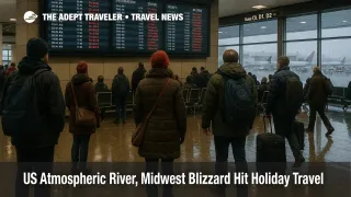
Airports and flight operations
On the aviation side, the atmospheric river is already translating into operational constraints at key hubs. Seattle Tacoma International Airport (SEA) and Portland International Airport (PDX) are dealing with low cloud, reduced visibility, and wet runways, which can trigger spacing on arrivals and deicing delays on departures. In recent days, San Francisco International Airport (SFO) has shown what happens when low clouds and fog collide with an already busy schedule, with an FAA ground delay program on December 8 pushing average arrival delays to between 36 and 82 minutes as the arrival rate was cut to 36 flights per hour, causing knock on delays across the US network.
As the clipper system digs into the central United States, airports from Denver International Airport (DEN) to Minneapolis Saint Paul International Airport (MSP), Chicago O Hare International Airport (ORD), and Detroit Metropolitan Wayne County Airport (DTW) are all exposed to bursts of snow, crosswinds, and blowing snow that can quickly slow operations. National weather coverage notes that winter storm warnings and winter weather advisories now extend across at least 16 states from Montana through the Dakotas, Minnesota, Wisconsin, and into parts of Michigan, Pennsylvania, New York, and Vermont, with some locations forecast to see up to 14 inches of snow and a mix of ice and freezing rain. The Federal Aviation Administration s daily air traffic report for December 10, 2025 highlights the risk of additional ground delay or ground stop programs as conditions evolve.
Travelers should pay particular attention to morning and late afternoon bank periods at these hubs, when a combination of deicing, runway configuration changes, and any traffic management initiatives can cascade into long lines at gates, missed connections, and forced overnight stays if misconnects happen late in the day.
Roads, interstates, and no travel advisories
On the ground, the hazard map is just as complex. In the Pacific Northwest, flooding and landslide risk affects sections of Interstate 5 between Portland and Seattle, as well as numerous state highways that dip into low lying river valleys. Even when mainline freeways remain open, standing water, hydroplaning, and debris on shoulders will slow traffic and increase crash risk, particularly at night.
Farther east, state transportation departments in Montana, North Dakota, Minnesota, and Wisconsin have issued winter storm warnings, travel advisories, and in some rural areas, no travel advised messages as the clipper brings heavy snow, mixed precipitation, and winds that can exceed 40 to 60 miles per hour. In Minnesota, public radio reports describe difficult driving on December 10 as communities dig out from heavy snow and gusty winds, with snow emergencies declared in multiple cities and many schools either closed or operating on delayed schedules. Key interstate corridors at risk of whiteout conditions and drifting snow include long stretches of Interstate 90 and Interstate 94 through the northern plains and Upper Midwest, as well as connecting routes along Interstate 35 and Interstate 29.
Drivers heading east toward the Great Lakes and interior Northeast will see the same storm evolve rather than end, as National Weather Service guidance suggests the clipper will spread wintry weather into interior New York and New England, with further snow and ice likely. For multi day road trips, this means conditions can be poor not only at the starting point but also hundreds of miles down the route, complicating hotel planning and fuel stops.
Background, what is an atmospheric river and an Alberta clipper
An atmospheric river is a long, narrow band of concentrated water vapor in the atmosphere that transports moisture from the tropics or subtropics into midlatitude regions. When such a plume stalls over terrain like the Cascades, it can produce days of heavy rain and mountain snow, leading to river flooding, landslides, and saturated soils. The current event has been classified by some forecasters as a high category atmospheric river, and it follows an earlier early December event that already primed watersheds.
An Alberta clipper is a fast moving low pressure system that forms in or near the Canadian Prairies and races southeast across the northern United States, usually bringing a quick hit of snow, strong winds, and a sharp drop in temperatures. Because clippers move quickly and often coincide with arctic air, they can produce dangerous wind chills and brief but intense whiteouts, especially on open stretches of highway. While each individual system can pass in a day or two, back to back clippers can keep parts of the Midwest in a nearly continuous pattern of slick roads and flight disruptions.
How this affects holiday travel planning
With just two weeks before Christmas, the timing of this storm sequence matters. Early December is normally a shoulder period when airlines and airports catch up on maintenance and staffing before the late month peak, but widespread warnings now mean that some flyers will bring trips forward or back and that airlines may use limited slack to reposition crews and aircraft. That increases the risk that knock on delays will linger even after the worst of the weather passes.
Travelers who are flexible should consider avoiding the tightest windows when both the atmospheric river and the clipper are at peak strength, especially December 10 and 11 along the northern tier, and any days when follow on systems are forecast. Those who must travel during this period should treat same day connections through hubs like Seattle, Minneapolis, Denver, and Chicago as higher risk and avoid separate tickets and self connecting itineraries. Adept readers can also cross check details with our December 10 US flight delays report for a daily look at which hubs are already under pressure. For more detail on the regional flooding side of this event, see our coverage of the BC Highway 4 closure and ferry cancellations, which unpacks how atmospheric river damage can strand coastal communities and disrupt ferry links that connect to US itineraries.
For drivers, the safest approach is to plan shorter daily segments, identify safe towns along the way where you can stop if conditions deteriorate, and use each state s 511 service or official travel websites to monitor closures and plow progress in near real time. A good rule of thumb during clipper driven blizzards is to avoid starting long rural stretches in the late afternoon, when daylight is fading and winds are often strongest.
Finally, this sequence is a reminder that winter storm travel risk is not just about snow totals. Flooded roadways in the Pacific Northwest, intense but brief snow bursts in the Midwest, and fog induced ground delays at distant hubs can all collide in one itinerary. Building a modest cushion into both flights and long drives, having a Plan B for overnight stays, and reviewing airline change or waiver policies in advance can turn a serious disruption into an inconvenience rather than a crisis. For a broader set of tactics on planning around winter storms, travelers can refer to our guide to US winter storm travel once it is live.
Sources
- Major atmospheric river brings heavy rain and flooding to Pacific Northwest
- Heavy rain in US Pacific north west brings fears of further flooding
- Driving remains difficult, snow emergencies in place as Minnesota digs out from winter storm
- Winter Storm Warning Map Shows Which States Will Get Hit
- Atmospheric River and Midwest Blizzard Disrupt U.S. Holiday Travel, Prompting Road and Flight Advisories
- FAA Daily Air Traffic Report