Southeast Asia Floods Reshape Travel Plans
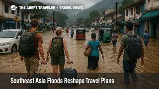
Southeast Asia floods travel plans after late November 2025 storms, as Sri Lanka, Sumatra, southern Thailand, and Malaysia count more than 1,700 deaths and billions in damage. The same cyclones and monsoon pulses that drove water to second story height in some towns also cut roads, bridges, and rail lines that tourists rely on to reach hill country, beaches, and cross border hubs. For the next few months, travelers need to treat the late November flood zone as a live constraint, not a one week spike, and rebuild itineraries around buffer days, higher ground neighborhoods, and more flexible flights.
In simple terms, the late November cyclones and associated monsoon floods have turned Southeast Asia floods travel into a structural planning issue for trips into Sri Lanka, Sumatra, southern Thailand, and parts of Malaysia, rather than a short lived weather scare.
How The Flood Pattern Has Shifted
The World Weather Attribution study on Cyclone Ditwah in Sri Lanka and Cyclone Senyar in the Malacca Strait concludes that a warmer North Indian Ocean made the heaviest rain bursts between roughly one third and more than one half more intense than they would have been without human driven warming. Sea surface temperatures in the basin were about 0.2 degrees Celsius above the recent 30 year average, and the analysis estimates they would have been about 1 degree cooler without the 1.3 degree rise in global mean temperature since pre industrial times.
That shift in baseline is why familiar floodplains in Sumatra and southern Thailand saw water reach second story level in some districts and why landslides wiped out entire road cuts instead of just dropping debris onto lanes that crews could clear in hours. For travelers, it means past experience with "normal" monsoon seasons is no longer a safe guide to what rural highways, railbeds, or small town drains can absorb.
Sri Lanka, Cyclone Ditwah, And Hill Country Access
Sri Lanka took a direct hit from Cyclone Ditwah on November 27, with one fifth of the country inundated at peak according to satellite analysis, around 2.3 million people exposed, and more than a million hectares flooded. The disaster management center has reported more than 600 deaths and hundreds missing, with major damage to bridges, local roads, and hillside communities that sit along the core tourist loop between Colombo, Kandy, Nuwara Eliya, and the southern beaches.
Bandaranaike International Airport (CMB) has remained open, but several Colombo bound flights were diverted to southern India at the height of the storm, and airlines warned passengers to check status before heading to the airport. Domestic rail and bus links into the hill country continue to see intermittent suspensions where landslides cut tracks or roads, especially on routes that follow river valleys or steep tea estate slopes.
Sri Lanka has also moved unusually fast to give visitors more room to maneuver. Authorities are offering free visa extensions for tourists and business travelers stranded by Cyclone Ditwah, waiving overstay penalties, and granting a seven day grace period to complete extension formalities. The government has publicly asked airlines to show flexibility on change fees and capacity, and reports from hotel and industry groups suggest overall cancellations are still modest, around 1 percent, even as small operators in flooded hill towns fight to recover.
For trip design, that combination of damaged inland roads and flexible rules points toward a few clear adjustments. Travelers should keep Colombo as their main air gateway for now, avoid tight turnarounds between long haul arrivals and same day drives into the hill country, and be ready to swap in coastal or cultural sites that sit on intact rail lines if particular valleys remain cut off. Onward connections out of Colombo should be booked with changeable fares and at least one full buffer day after any multi day inland loop.
Sumatra, Senyar, And Indonesia's Inland Corridors
On the Indonesian side, Cyclone Senyar developed in the Strait of Malacca and drove devastating floods and landslides across Aceh, North Sumatra, and West Sumatra. Government tallies now count roughly 950 confirmed deaths on Sumatra with hundreds still missing, more than 3 million people affected, and around 1 million displaced, alongside damage estimates above 3 billion dollars in recovery needs. Local reports describe hundreds of bridges destroyed, thousands of houses washed away, and some inland villages reachable only by air or temporary Bailey bridges that the military is installing.
For tourism, the picture is mixed rather than simply closed. Key destinations such as Lake Toba, Bukittinggi, and some coastal areas remain operational, and regional tourism bodies are already emphasizing that airports and core visitor services are open even as rural communities rebuild. The practical constraint is movement between pockets of intact infrastructure, especially where standard itineraries would cross districts that saw bridge collapses or slope failures.
Travelers planning Sumatra legs should treat all overland segments through Aceh, North Sumatra, and West Sumatra as provisional until they can cross check against fresh advisories from Indonesia's disaster agency and local operators. It makes sense to favor itineraries that backtrack to the same hub airport, use return flights instead of ambitious open jaw routes, and keep hiking, rafting, or volcano excursions flexible, since access roads to trailheads are precisely the kind of assets that fail when flood heights jump.
Southern Thailand And Malaysia, Flooded Gateways
Further north, southern Thailand and northern Peninsular Malaysia have endured the worst flooding on record for several provinces. Hat Yai, the commercial center of Songkhla and a major overland gateway near the Malaysian border, recorded its heaviest daily rainfall in at least 300 years, with floods that paralyzed roads, cut rail lines, and stranded thousands, including foreign tourists. Government figures point to more than 180 deaths in southern Thailand, hundreds of thousands of damaged homes, and damage estimates around 500 billion baht, about 15.6 billion dollars.
In Malaysia, floods have displaced thousands across eastern and southern states, and regional coordination bodies report sustained impacts in Kelantan, Terengganu, Johor, and linked cross border corridors into Thailand. Malaysian officials have advised deferring non essential travel to flood hit parts of southern Thailand and Vietnam, and the consulate in Songkhla has issued specific warnings about road and rail disruptions.
For most international visitors, major destinations such as Phuket, Krabi, and the main Gulf islands remain reachable, and airports like Phuket International Airport (HKT) and Krabi International Airport (KBV) have stayed open. The weak points are secondary highways, regional rail lines, and low lying districts in southern cities where digital nomads and long stay visitors often rent apartments because they are cheaper and closer to bus or rail stations. Hat Yai International Airport (HDY) has functioned as an essential relief hub, but access roads and suburban neighborhoods around it have seen repeated flooding, so it is a less reliable entry point than usual for overland loops into Malaysia or the Gulf islands.
Planning Scenarios For The Next Few Months
For Sri Lanka, a standard ten to fourteen day loop that combines Colombo, hill country tea towns, and southern beaches is still possible, but it needs more slack. Build at least one buffer day into any sequence that involves mountain roads, avoid night driving in landslide prone districts, and lean on rail where it remains operational, since tracks are often cleared and inspected before nearby back roads. Use the free visa extension and overstay waiver as a safety net rather than something to burn by design, and keep proof of delay ready in case you need to self declare.
For Indonesia, treat intra Sumatra moves as higher risk than flights between Sumatra and major hubs such as Jakarta or Singapore. It may be smarter to base in one relatively intact region, for example around Lake Toba, instead of stringing multiple provinces together, and to buy flexible tickets that allow you to re route through Kuala Lumpur International Airport (KUL) or Singapore if a planned local transfer fails.
For Thailand and Malaysia, digital nomads and long stay visitors should pay more attention to neighborhood siting than usual. Choose higher ground districts with better drainage, buildings that keep living and working spaces above street level, and locations with more than one access road, so a single flooded junction does not trap you. Where possible, fly directly into primary gateways such as Bangkok, Phuket, or Kuala Lumpur for regional hops, and see overland routes through Hat Yai and other southern hubs as weather dependent.
For multi country trips, the biggest adjustment is mental. Instead of assuming that roads, ferries, and trains will work unless there is a breaking news alert, assume that climate shifted flooding can cut any low lying corridor on short notice, and design your route so that you can remove or reorder segments without compromising key long haul legs. That typically means locking in flexible long haul tickets into Colombo, Bangkok, Kuala Lumpur, or Singapore, then layering in regional hops with clear fallbacks, such as an extra day in a hub city if an overland leg proves impossible.
Background, How Attribution Studies Feed Into Travel Planning
Attribution groups such as World Weather Attribution use peer reviewed methods and climate models to compare real world events with simulated worlds that lack human driven warming, then quantify how much more likely or intense a storm or flood has become. In this case, those studies found heavy rain events 28 to 160 percent stronger around the Malacca Strait and up to 50 percent more intense in Sri Lanka, and linked that to warmer seas, a moister atmosphere, and local factors such as deforestation and urbanization of floodplains.
For travelers, the practical takeaway is not that these exact storms will repeat next year, but that routes, towns, and resort belts that previously sat on the edge of realistic worst case scenarios are now squarely inside them. When governments respond with tools such as visa flexibility, targeted travel advisories, and hardening of key corridors, as seen in Sri Lanka and parts of Indonesia already, those policy shifts become as important to trip planning as timetables and room rates.
Over the coming seasons, Southeast Asia floods travel will increasingly be about using climate aware habits, such as booking flexible fares, avoiding tight overland chains, and preferring well connected hubs, to keep trips enjoyable even as baseline risks change.
Sources
- Increasing heavy rainfall and extreme flood heights in a warming climate threaten densely populated regions across Sri Lanka and the Malacca Strait, World Weather Attribution
- Deadly November Asian storms 'supercharged' by climate change, Reuters
- Climate crisis supercharged deadly monsoon floods in Asia, The Guardian
- One fifth of Sri Lanka inundated by Cyclone Ditwah, UNDP
- Sri Lanka eases tourist visa rules, asks airlines for flexibility, Gulf News
- Sri Lanka is offering flexible visa and travel relief for tourists hit by Cyclone Ditwah, Economic Times
- Deadly cyclone dents Sri Lanka's peak tourism season, Reuters
- Indonesia says more than $3 billion in recovery funds required after Sumatra floods, Reuters
- Sumatra tourism remains operational as floods recede, TTG Asia
- Thailand's record floods paralyze key hubs, Insurance Journal
- Flash Update, Flooding in Peninsular Malaysia and Southern Thailand, AHA Centre
- Southern flooding a blow to tourism, Bangkok Post
- Is it safe to travel to Sri Lanka during severe flooding, The Independent