Bali High Waves To Disrupt Ferries December 12 to 15
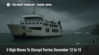
Tropical cyclone seed 93S south of Indonesia is pushing a new round of stormy weather and rougher seas into Bali, Lombok, and parts of Nusa Tenggara Timur. The immediate problem for travelers is not a direct cyclone landfall, it is indirect impacts, including heavier rain, stronger squalls, and elevated wave heights that can knock fast boats and some ferry operations off schedule. Anyone relying on same day sea connections should add buffers now, and avoid stacking a tight boat transfer with hotel check ins, tours, or onward flights.
The Bali high waves warning matters most on the tourist corridors that depend on small vessels and exposed straits, where "moderate" seas on paper can still translate into uncomfortable rides, cancellations, and port holds.
What BMKG Says About 93S, And Why It Still Matters
BMKG says tropical cyclone seed 93S was detected in the Indian Ocean south of Nusa Tenggara Barat, and entered the Tropical Cyclone Warning Centre Jakarta monitoring area on December 11, 2025. BMKG expects the system to move away from Indonesia, but it warns the disturbance can still drive indirect impacts, including moderate to heavy rain in Bali, Nusa Tenggara Barat, and Nusa Tenggara Timur over the next several days.
BMKG's headline marine risk is moderate high waves of 1.25 to 2.5 meters across southern waters, including the Indian Ocean south of East Java through NTT, and the southern parts of the Bali, Lombok, and Alas straits. BMKG also notes the seed may slowly intensify over the 48 to 72 hours after the bulletin while continuing to move away, which is a reminder that conditions can stay messy even if the "center" is not approaching land.
Where High Waves Are Most Likely For Tourists
BMKG's maritime warning system defines "moderate" waves as 1.25 to 2.5 meters, a band that is often enough to trigger small craft restrictions and fast boat disruptions on exposed routes. The straits and coastlines travelers should treat as the highest risk areas are the south facing waters and the southern strait segments, where swell energy is less sheltered.
For Bali's day trip geography, Selat Badung is a core pinch point because it sits on the path between Bali and Nusa Penida, and it is also adjacent to the island's southern and southeastern boating lanes. BMKG's maritime forecast for Selat Badung shows moderate seas around 1.6 meters within a validity window that runs through December 15, 2025. South of Bali, BMKG's "Perairan Selatan P. Bali" forecast likewise shows moderate seas around 1.7 meters during the same period.
To the east, the Lombok and Alas strait segments that matter for Lombok, Sumbawa, and onward island hopping also show moderate conditions in BMKG guidance. BMKG's Selat Lombok bagian selatan page flags a moderate wave warning with a listed height near 1.7 meters and a warning period that runs from December 13 to December 15, 2025. BMKG's Selat Alas bagian selatan forecast also shows moderate seas around 1.6 meters, paired with thunderstorm conditions in the same forecast window through December 15, 2025.
For travelers pushing farther east into NTT, BMKG's Samudra Hindia selatan NTT forecast shows moderate seas around 1.5 meters alongside recurring thunderstorm markers during the current cycle. That matters most for any south coast activities, plus any open water legs that face the Indian Ocean rather than the more sheltered northern seas.
Which Boat Routes Are Likely To Be Curtailed First
Travelers often underestimate how quickly operators will pull back on smaller passenger vessels in the Bali region. The first routes to degrade are usually the fast boats that run on tight schedules, carry tourists with luggage, and cross exposed channels.
The most common risk set looks like this. Bali to Nusa Penida routes that rely on crossings through Selat Badung can see holds or cancellations when seas build, even if the weather at the departure beach looks "fine" from shore. Bali to Lombok and Bali to the Gili Islands services are exposed both to localized squalls and to rougher segments in the Lombok Strait system, particularly on southern lanes. Lombok to Sumbawa and onward NTT legs can be affected as the Alas Strait and south facing waters turn choppy, especially when thunderstorms are embedded in the forecast.
The key operational reality is that cancellations are often made for safety, but the knock on traveler impact is administrative. Refunds can be slower than expected, rebookings can be forced into later sailings, and the best alternate seats can disappear quickly once multiple operators start reshuffling.
Ferries, Ports, And What The Forecasts Suggest
For vehicle and freight capable ferries, the risk is usually less about comfort and more about port timing, loading windows, and operational limits. That is why travelers should look at port level forecasts, not just regional headlines.
BMKG's maritime forecast for Pelabuhan Padangbai shows a validity period through December 15, 2025, and lists wave conditions reaching the moderate band, including a 1.25 meter wave reading in the forecast table. Pelabuhan Lembar's port forecast, which is relevant to Bali to Lombok vehicle ferry flows, is also valid through December 15, 2025, although the wave height displayed in the port table can be lower than the roughest segments of the crossing. This mismatch is common, port basins can look manageable even when the open water leg is not.
For tourists, the key takeaway is that a "normal" looking port does not guarantee a normal crossing. The controlling factor is often the most exposed portion of the route, plus whether squalls are moving across the strait during the planned sailing window.
Practical Buffer Guidance For Bali, Lombok, Nusa Penida, And NTT
Travelers should plan as if sea crossings are conditional through December 15, 2025, especially if the trip relies on fast boats or small passenger vessels. The cleanest mitigation is time. An overnight buffer on either side of a critical crossing, for example before a long haul flight or a nonrefundable resort check in, will beat any day of scrambling later.
For Bali to Lombok moves, flights can be a practical substitution if seas deteriorate, particularly between I Gusti Ngurah Rai International Airport (DPS) and Lombok International Airport (LOP). For NTT legs where boats are part of the plan, travelers should assume the weakest link is the most exposed water segment, and be ready to shift to flying for the longest jumps if operators start issuing weather holds.
For south coast water activities, the advice is blunt. Treat cliff walks, shoreline access, and small boat excursions as optional during squalls and elevated surf, because conditions can change quickly, and rescues become harder when wind and waves rise. BMKG explicitly urges maritime users to adjust activities based on official wave warnings, and that guidance applies to tourists just as much as it does to commercial operators.
For related regional context, this update builds on Adept Traveler's broader Southeast Asia flooding coverage, and the way weather can cascade into same day connections and accommodation logistics when multiple modes are stacked into a single itinerary.
Sources
- BMKG: Perkembangan Bibit Siklon 93S di Selatan Indonesia, Waspada Hujan dan Gelombang Tinggi di Bali, NTB, NTT
- BMKG Maritime, Peringatan Gelombang Tinggi
- BMKG Maritime, Prakiraan Cuaca Perairan Selat Badung
- BMKG Maritime, Prakiraan Cuaca Perairan Perairan Selatan P. Bali
- BMKG Maritime, Prakiraan Cuaca Perairan Selat Lombok Bagian Selatan
- BMKG Maritime, Prakiraan Cuaca Perairan Selat Alas Bagian Selatan
- BMKG Maritime, Prakiraan Cuaca Perairan Samudra Hindia selatan NTB
- BMKG Maritime, Prakiraan Cuaca Perairan Samudra Hindia selatan NTT
- BMKG Maritime, Prakiraan Cuaca Pelabuhan Padangbai
- BMKG Maritime, Prakiraan Cuaca Pelabuhan Lembar