Flooding, Abbotsford Highway 1 Reopens With Delays
Flooding impacts in the Fraser Valley have eased enough for traffic to move again on Highway 1 through Abbotsford, but the corridor is still a high risk bottleneck for holiday period driving. Drivers traveling between Metro Vancouver and the Fraser Valley, plus anyone planning a same day drive toward the Interior or a cross border appointment near Abbotsford, should expect slower speeds, heavier congestion, and the possibility of renewed closures. The practical move is to add buffer, avoid tight connections to flights or ferries, and keep a detour plan ready before you leave.
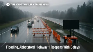
The Highway 1 Abbotsford flood delays problem has shifted from a full closure to a constrained, vulnerable reopening, with only one eastbound lane available through the previously flooded stretch.
As of the morning of December 14, 2025, the Province said one eastbound lane and both westbound lanes reopened on Highway 1 in Abbotsford between Highway 11 and No. 3 Road, after floodwaters receded enough for crews to restore limited service. Officials also warned drivers to expect reduced speeds, eastbound congestion, and ongoing vulnerability, with the corridor able to close again if conditions change and more rain arrives.
For travelers, the key planning point is that "open" does not mean "normal." A single eastbound lane is still a choke point, and it can turn a routine Vancouver to Abbotsford drive into a long, stop and go queue at the worst possible time, namely when you are trying to reach an airport check in deadline, a ferry reservation, or a timed border crossing appointment. If you have flexibility, shifting your drive window away from peak commuter hours reduces the chance you get trapped in a low speed crawl with no easy exit.
Background
This disruption sits on top of a broader flood response in Abbotsford's Sumas Prairie area, where the City has been tracking receding floodwaters, evacuation status, and road conditions day by day. In its December 14 community update, the City said floodwaters were gradually receding, but that overflow water was still coming across the Canada and U.S. border from the Nooksack River, even as the volume of that overflow was decreasing. That cross border hydrology is part of why road status can change quickly, because water moving through low lying farmland and drainage channels can keep side roads flooded even after the main highway begins to reopen.
The forecasting backdrop matters too. Environment Canada posted a rainfall warning for the Fraser Valley east including Hope on December 15, 2025, calling for 40 to 60 mm of rain during the day, with the system easing by early evening. Separately, EmergencyInfoBC's flood information page, updated December 15, 2025, listed active flood advisories including a Flood Warning for the Sumas River, among other areas. Put together, that means travelers should treat the reopening as conditional, not permanent.
What the reopened Highway 1 segment means in practice
If you are driving westbound toward Metro Vancouver, the Province said the reopening lets drivers remain on Highway 1 rather than detouring via Highway 7, which should reduce the worst case time penalties compared with the fully severed days. If you are driving eastbound, the single lane configuration is the bigger problem, because the Province explicitly flagged congestion risk and advised drivers to give themselves additional time.
That has direct trip planning consequences:
If you are making a same day airport run, build more margin than you normally would. Vancouver International Airport (YVR) departures are still achievable from Metro Vancouver and the Fraser Valley, but the risk now is not distance, it is unpredictability from lane reductions, slow speed zones, and the possibility of another closure if water rises again. Abbotsford International Airport (YXX) is geographically closer for many Fraser Valley travelers, but local access roads in the Sumas Prairie area can remain compromised even when the freeway is passable, so confirm your approach route before you commit.
If you are using a rental car with a drop deadline, treat the corridor as a high variance leg. The smartest move is to pad enough time that you can absorb a sudden slowdown without having to speed or take questionable side roads through flood prone areas.
If you are planning an Interior drive, be aware that the Province also flagged how heavy rain can force proactive closures in other key corridors. On the night of December 14, 2025, the Ministry advised of precautionary overnight closures on Highway 99 east of Pemberton, and on Highway 1 through the Fraser Canyon between the Hope junction and Lytton, due to slide and washout risks during heavy rain and snowmelt. Even if those specific closures have already lifted, they illustrate the operating reality this week, which is that the Lower Mainland to Interior network can see rapid, weather driven shutdowns that break long distance itineraries.
Detour realities and when to postpone
During the worst of the flooding, officials used Highway 7 as a key detour option, and the Province's traffic advisory language makes clear that detours can return quickly if lanes are lost again. That matters because detours are not equal substitutes, especially for travelers with trailers, larger vehicles, or a strict schedule.
Trip types that are most rational to postpone if you can:
Non essential day trips that cross Abbotsford in either direction, particularly if you would be relying on local side roads near the Sumas Prairie area for shortcuts or alternate access. The City has explicitly warned against attempting to bypass flooded areas using side roads, because those roads can be flooded as well, and drivers can get stuck.
Cross border errands with tight appointment windows near Abbotsford, because even when the freeway is open, the last mile approach can be the part that fails if local closures expand. If you must go, plan a backup crossing, and allow time to reroute.
Same day "drive plus flight" plans without flexibility, especially if missing the flight would be costly. If you cannot move the flight, shift the drive earlier, or consider an overnight stay closer to the departure point.
Related coverage for travelers
Travelers dealing with flood and storm driven transportation disruption across the wider region may also want a broader situational view of how atmospheric river patterns are affecting holiday travel planning, plus an evergreen way to track water driven disruption risk. See Adept Traveler's coverage of U.S. atmospheric river and holiday impacts, and keep the River Levels hub bookmarked as a practical framework for interpreting flood and hydrology signals that often translate into transport constraints.
Sources
- Highway 1 in Abbotsford now open in both directions, Province of B.C.
- Westbound travel on Highway 1 in Sumas area now open, Province of B.C.
- Precautionary overnight closures of Highway 99, Highway 1, Province of B.C.
- City of Abbotsford flood update and community alerts
- City of Abbotsford road closures
- Environment Canada weather alerts, Fraser Valley east including Hope
- EmergencyInfoBC, B.C. Flood Warning Information