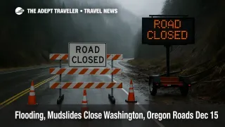
Flooding, Mudslides Close Washington, Oregon Roads Dec 15
Washington Oregon flooding road closures remain a live problem on December 15, 2025, as rivers stay high, and mudslide risk persists on steep corridors. Travelers driving between metro areas, mountain towns, ski corridors, and smaller river valley communities are most exposed, especially if their itinerary depends on a single highway approach. The practical move is to shift departures earlier, avoid night driving in slide prone areas, and book contingency lodging near airports instead of committing to long cross region drives that can unravel late in the day.
The Washington Oregon flooding road closures situation is no longer just a forecast problem, several key routes have documented damage and active closures, and flood warnings are still being renewed on specific rivers.
The most consequential Washington choke point for holiday season itineraries is US 2, where reporting based on Washington State Department of Transportation information indicates a closure spanning from near Skykomish to the Leavenworth area because of multiple stretches of damage from landslides, washout, and flooding. That corridor is a common access route for Stevens Pass area travel, and for travelers aiming for Leavenworth, Washington, or crossing the Cascades on a time sensitive schedule. A local joint press release from the City of Leavenworth also warned that multiple closures remain on city streets, county roads, and state highways, severely limiting accessibility, which is exactly the pattern that strands visitors once a single approach road fails.
In western Washington, flood impacts remain tied to river systems and dam releases, not only rainfall totals. A National Weather Service flood statement issued early December 15, 2025, continued flood warnings for multiple river points, including the Cedar River, Green River, and the White River, and it explicitly noted that dam operations can increase or maintain elevated flows below dams. For travelers, that matters because a road that looks passable at noon can become a barricaded segment later if water rises again, or if debris loads increase.
Oregon drivers should treat the coast range and lesser traveled connectors as fragile, not just the big interstates. Oregon Department of Transportation TripCheck listed an active closure on OR 229 about 10 miles north of Siletz, citing a landslide that closed the highway and advising travelers to use an alternate route, with the item updated at 4:10 a.m. on December 15, 2025. That type of closure is especially disruptive because alternate routes can be limited, slow, and more exposed to additional slides.
Wind is also part of the same disruption picture, because high winds convert saturated ground into tree fall and downed line risk, which then creates new road hazards and stop and go traffic near utility work. TripCheck included a High Wind Warning covering coastal areas, with an issue timestamp on December 15, 2025, and it warned that travel can be difficult, especially for high profile vehicles. If your plan includes coastal driving, or north south routes exposed to gusts, build extra margin even if your specific road is technically open.
Background
Flood warnings and landslide closures behave differently than snowstorms. Snow disruptions often track forecast timing, plow operations, and traction requirements, while flooding and slides can spike after the heaviest rain because saturated slopes fail later, and rivers crest hours after upstream rainfall. That is why official river warnings and road condition feeds, not social media screenshots, should drive your go, delay, or cancel decision.
To monitor conditions without getting trapped in constant refresh loops, use three official checks in a tight sequence. First, check National Weather Service warnings for your specific river basin and county, because flood statements often highlight which gauges are above flood stage, and whether water is expected to remain elevated for days. Second, check your state DOT live incident feed, Washington State Department of Transportation for Washington routes, and Oregon Department of Transportation TripCheck for Oregon routes, focusing on closures, conditional closures, and weather warnings. Third, check the last 6 to 12 hours of updates, not only the headline status, because frequent revisions usually signal an unstable situation where new closures are plausible.
When to cancel the drive, versus reroute safely, comes down to a simple traveler rule, do not accept single point failure routing. If your itinerary relies on one canyon road, one pass crossing, or one bridge approach that has no nearby alternate, the downside is too high, because a closure can leave you hours from lodging with no practical turnaround options. In that case, rebook to a rail or flight segment where possible, or move lodging to the airport city and complete the final leg later when the road network stabilizes. If you do reroute, favor major highways with multiple services and exits, and keep your fuel above half a tank, because detours often add distance and reduce access to open gas stations during power outages.
Airport anchored trips need a separate buffer rule. If you must catch a flight from Seattle Tacoma International Airport (SEA) or Portland International Airport (PDX), plan to arrive in the metro area the night before if your drive includes mountain corridors, coast range routes, or river valleys under warning. On December 15, 2025, the odds of a last minute closure or a long, slow detour are high enough that same day, long distance airport drives are an avoidable risk, not bad luck.
The bottom line is that the Pacific Northwest road network is operating in a fragile mode. Flood warnings can stay active after the rain band moves, and slides can close smaller connectors that you would normally treat as easy alternates. Travelers who plan around official feeds, daylight driving, and backup lodging will have far fewer hard failures than travelers who treat navigation apps as the only source of truth.
Sources
- National Weather Service Flood Warning Text, Seattle WA, December 15, 2025
- Oregon Department of Transportation TripCheck, Statewide Road Conditions, December 15, 2025
- City of Leavenworth Joint Press Release, December 11, 2025
- KOMO News, US 2 Closure Impacts Near Leavenworth, December 15, 2025
- OPB, Atmospheric River Flooding and Oregon Coast Closures, December 8, 2025
- AP News, Tens of Thousands Ordered to Evacuate in Washington Flooding, December 11, 2025