Spain Flash Floods Disrupt Andalusia, Valencia Travel
Flash flooding hit parts of southern and eastern Spain after torrential rain swept across Andalusia and into the Valencia region. Holiday travelers heading for winter sun corridors, including the Costa del Sol and Málaga province, faced a fast shifting mix of flooded streets, hazardous driving, and interruptions to normal local mobility. If you are traveling into, out of, or within the affected areas, the practical move is to treat transfers as the weak link, add buffer, and be willing to reroute or overnight rather than trying to force tight same day
connections.
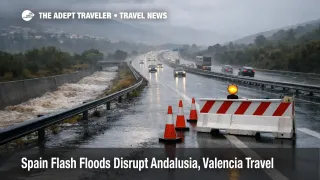
Spain flash floods Andalusia Valencia conditions changed travel plans because the disruption was not just the rain itself, it was the way flooding temporarily breaks the road network that connects airports, stations, hotels, and day trip areas. Reuters reported at least one death and active searches for missing people as of December 28, 2025, while other reporting indicated additional fatalities as confirmations continued, a reminder that the main traveler risk is being on the road at the wrong moment, especially near normally dry channels that can turn into torrents.
In eastern Spain, the public weather warning system escalated to the highest tier in parts of Valencia province during the episode, with authorities urging residents to stay put and move away from low lying areas when needed. By Tuesday, December 30, 2025, broad warnings had generally eased, but the traveler impact can linger because waterlogged ground, debris, and local road restrictions do not clear on the same timeline as the radar.
Who Is Affected
Travelers are most exposed if they are driving or taking ground transport in Málaga province, including the Costa del Sol resort belt, inland towns on river and stream corridors, and mountain routes that rely on narrow roads and steep drainage. Even when major highways remain open, the approach roads that feed beach towns, villas, rural hotels, and excursion meeting points can flood first, and reopen last, which is how a short weather window becomes a multi hour delay.
Visitors in the Valencia region are affected in a different but equally frustrating way. Urban flooding and police restrictions can slow access to Valencia Airport (VLC), and rail service can become uneven when water affects track approaches, signaling, or station access. Travelers connecting onward to Alicante, Spain, Castellón, Spain, or Barcelona, Spain can also see knock on changes as rolling stock and crews end up out of position, and as operators try to protect the rest of the network by trimming service in the hardest hit segments.
Arriving passengers are often hit harder than departing passengers because their plans depend on last mile transport. A flight that lands close to schedule is still a problem if the road to the hotel is flooded, if rideshare supply is tight due to traffic restrictions, or if a regional train is paused while infrastructure is inspected. Peak holiday occupancy makes this worse because the easiest fallback, a same night hotel near the airport or station, sells out quickly.
What Travelers Should Do
If you are traveling within the next 24 hours, treat ground transport as the gating factor. Check the current warning level for your specific province and municipality, then confirm your road and rail options before you leave lodging, not after you are already in a taxi or on a rural road. Build a buffer that is large enough to survive a detour, and if you are driving, plan routes that stay on higher capacity roads and avoid underpasses, riverbeds, and normally dry channels that can flash flood.
Use a simple decision threshold for rebooking versus waiting. If your itinerary depends on a tight airport to rail connection, or a late evening arrival followed by a long drive to a resort, shift to an earlier departure, a daylight transfer, or an overnight near the arrival node. When warnings are at the highest tier in your area, or when rail operators show suspended segments, waiting for a same day fix is usually the wrong bet because the backlog grows faster than capacity returns, and a voluntary overnight often beats a forced one.
Over the next 24 to 72 hours, monitor three things: the local warning level, the status of key approach roads, and service advisories from rail and airport operators. Even if the rain has moved on, closures can recur when drainage systems clog, when cleanup crews restrict lanes, or when another band of showers hits saturated terrain. If you are on separate tickets, protect the most expensive, least flexible segment first, then rebuild the rest around the new reality.
Background
Flash floods in Spain often become travel disruptions because the drainage pattern is highly concentrated. A dry looking streambed, a coastal underpass, or a normally harmless arroyo can turn into a fast moving channel in minutes, and the first operational response is to close access, reroute traffic, and prioritize emergency movement. That is the first order effect at the source: roads, local bridges, and low crossings become unsafe, and everything that depends on them slows down.
The second order ripple spreads through the travel system. When road access degrades, passengers and crews arrive late to airports and stations, which increases missed departures and forces rebooking into a peak period when seats and rooms are already constrained. Rail operators may hold or suspend service on specific segments to protect safety and equipment, which then causes rolling stock to end up in the wrong place for later departures. Hotels near transport nodes compress because stranded travelers need unplanned nights, and tours cancel because guides cannot safely reach sites or because authorities close parks, trails, and waterfront areas until inspections and cleanup are complete.
For travelers, the key is to separate what is controllable from what is not. You cannot control where the heaviest rain falls, but you can control transfer timing, routing choices, and whether you have a realistic overnight fallback near Málaga Costa del Sol Airport (AGP) or Valencia Airport (VLC) when the last mile breaks.