Caribbean Flash Flood Outlook For Feb And Mar Trips
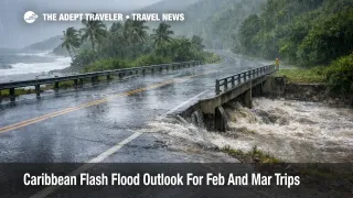
A new regional climate signal is on the table for Caribbean trips in February and March, and it is the kind that does not cancel vacations, but it does break tight itineraries. The Caribbean climate outlook for January to March 2026 indicates no big change from the usual number of excessive rainfall events overall, yet it flags specific hotspots where a single intense downpour can still trigger flash flooding. Travelers should use this as a planning input now, choosing lodging on higher ground, building buffers into transfer days, and treating heavy rain forecasts as a reason to delay drives rather than push through.
The practical shift is that the risk is uneven. The outlook highlights extremely high flash flood potential in much of the Guianas, high to extremely high potential in mountainous areas of the Greater Antilles, and high potential in places that many winter travelers treat as "dry season safe," including The Bahamas, southern Belize, Martinique, and St. Vincent. It also uses a clear operational definition of an excessive rainfall event, at least 30 mm in 24 hours, which helps travelers understand how little rain it takes to tip an island road network into disruption.
Who Is Affected
This affects travelers most when their itinerary depends on road reliability and timed arrivals. If you are planning self drive days, private transfers across island interiors, or early morning airport runs, you are in the highest exposure group because flash flooding usually hits mobility before it hits anything else. Visitors staying in low lying coastal strips, near gullies, river mouths, or steep drainage channels are also more exposed, because nuisance flooding and access constraints can appear quickly even when the rest of the island feels normal.
The highest flagged areas are not only "deep tropics" destinations. The outlook points to the Guianas, southern Belize, mountainous corridors in the Greater Antilles, and specific island zones such as The Bahamas, Martinique, and St. Vincent. That mix matters because many February and March trips combine beach stays with interior day trips, waterfall hikes, rum distillery tours, or cross island drives, and those are exactly the activities that fail first when short fuse rain hits.
What Travelers Should Do
Start with lodging and routing decisions that reduce downside. Favor accommodations on higher ground with multiple access roads, and avoid booking the lowest lying rooms or villas that sit next to obvious drainage paths. When you have a choice, plan driving days so the longest crossings and interior roads happen earlier in the day, and keep at least one flexible day that can absorb a weather pause without forcing you into a risky night drive.
Use clear decision thresholds for rebooking versus waiting. If local forecasts call for intense rainfall or flash flood watches in the specific parish, district, or island corridor you must drive through, treat that as a reason to delay the transfer, change the tour day, or shift to a closer activity, especially if your plan requires a low bridge, a gully crossing, or a steep interior route. If your flight departure depends on a single coastal road, move your airport run earlier than you think you need, and be willing to pivot to an overnight near the airport when heavy rain is forecast during your transfer window.
Over the next 24 to 72 hours around any heavy rain forecast, monitor three things, not just one. Watch the local meteorological service for updates and alert levels, check police or road agency channels for closures and detours, and confirm with your hotel or transfer provider which access roads are currently passable. If you encounter flooded pavement, do not attempt to judge depth by what other drivers are doing, because water can hide washouts and undermined road edges, and conditions can change faster than a navigation app can reroute you.
Background
These outlooks are useful because they describe how disruption propagates through a travel system that is deceptively fragile in heavy rain. The first order effects usually begin with drainage failure, low crossings becoming unsafe, and localized power or water interruptions that follow short, intense rainfall. Once that happens, the second order ripple reaches the rest of your trip fast: transfers to airports slow or detour, tours cancel because guides cannot guarantee safe routing, and ferry schedules thin when crews, passengers, and vehicles cannot reliably reach ports on time. Even when flights operate normally, misconnect risk rises because ground access becomes the limiting factor, not the runway.
For context on how quickly island mobility can degrade after heavy rain, see Barbados Floods Keep Roads and Buses at Risk, which shows how saturated soils and debris can keep transfer times unreliable even after warnings are downgraded. For a storm scale example of how flooding and infrastructure impacts spill into airport operations and payments connectivity, see Hurricane Melissa: Cuba Airports, Power, and Travel. If you want a broader playbook mindset for building buffers around forecast driven operational constraints, even outside the Caribbean, The 2025 European Heatwave's Impact on River Cruises is a useful reference for how experienced operators manage weather linked uncertainty and what that means for traveler decision making.