Weekend Winter Storm Threat Builds Across US South and East
Forecast confidence is increasing around a new winter storm system expected to affect large parts of the US South, the Mid Atlantic, and the East Coast over the weekend of Saturday, January 24, and Sunday, January 25. Meteorologists flag this setup as potentially high impact because it combines cold surface air with moisture moving out of the Gulf, a classic recipe for snow and freezing rain across regions that lack robust winter response capacity. For travelers, this matters now because there is enough lead time to reroute, rebook, or leave early before airline schedules tighten and highways deteriorate.
The key change versus earlier January storms is geography. This is not a Northeast focused snow event. The highest disruption risk sits farther south, where ice rather than snow is likely to drive closures and cascading delays.
Who Is Affected
Travelers driving, taking rail, or flying short haul routes through the South and eastern half of the United States face the most exposure. The most vulnerable corridor runs from north Texas and the lower Mississippi Valley through the Southeast, then north into the Mid Atlantic. Even light ice accumulation in these areas routinely shuts down airport ground operations, closes interstates, and halts rail traffic.
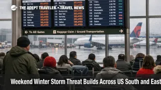
Airports in the Southeast and lower Mid Atlantic are particularly exposed because they handle high volumes of connecting traffic but operate with limited deicing equipment compared with northern hubs. When ramps ice over, arrivals are metered aggressively, departures stack up, and recovery options thin quickly. Travelers using secondary airports in these regions often have fewer alternate flights, which raises the risk of overnight delays or forced ground transport.
What Travelers Should Do
Travelers with flexibility should strongly consider shifting departures to Friday, January 23, or delaying until Monday, January 26, especially for itineraries involving connections in the Southeast or Mid Atlantic. Leaving earlier can avoid the peak icing window, while waiting allows time for crews, aircraft, and road crews to reset.
For those who must travel during the weekend, decision thresholds matter. If forecasts continue to show freezing rain along your route or at your connecting airport by Thursday evening, January 22, rebooking proactively is usually safer than waiting for day of waivers, which can coincide with sold out flights and long customer service queues.
Over the next 24 to 72 hours, monitor National Weather Service advisories, airline travel alerts, and state department of transportation road condition maps. Pay close attention to temperature forecasts near freezing, not just snowfall totals, because ice drives the worst operational outcomes in the South.
Background
Winter storms disrupt travel through more than just precipitation. At the source, ice and snow slow aircraft turn times due to deicing, reduce runway braking action, and force air traffic control to space arrivals farther apart. In southern airports, even brief icing can halt operations entirely because equipment and staffing levels are lower than in northern hubs.
Those first order impacts quickly ripple outward. Aircraft that cannot depart remain out of position, which cancels later flights hundreds of miles away. Crews time out, reducing available staffing the following day. On the ground, icy interstates shut down rental car returns and airport access roads, while rail systems suspend service due to frozen switches and safety rules.
The second order effects are often where travelers feel the most pain. Hotels near affected airports fill as stranded passengers extend stays. Rental cars become scarce or prohibitively expensive for those attempting long drives around closed airspace. Even travelers flying outside the storm zone can see delays as the national network absorbs displaced planes and crews.