Patagonia Fires Hit Los Alerces Park Access
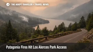
Wildfires burning across Argentina's Patagonia region are continuing into early February 2026, with Los Alerces National Park in Chubut among the best known areas facing disruption. Conditions are dynamic, with active fire behavior shifting by wind, humidity, and terrain, and authorities using closures and controlled access to protect visitors, residents, and firefighting operations. Travelers planning hikes, scenic drives, lake activities, and guided tours in the Esquel and Trevelin area should assume plans may change the same day, and should build a reroute option before arriving.
The immediate travel problem is not just the fire footprint, it is the operational perimeter around it. Parks can close sectors to keep people away from active fronts and to create room for aircraft and ground crews to work safely, and access roads can be restricted or closed when visibility drops, when firefighting traffic surges, or when conditions create evacuation risk. Reporting in late January and early February describes significant burned area and ongoing emergency operations in the Los Alerces zone, with authorities emphasizing protection of life and property alongside suppression work.
Who Is Affected
Travelers with fixed date Patagonia itineraries are most exposed, especially those planning long hikes, lake days, and multi stop self drive loops that depend on specific park entrances, specific lake corridors, or timed tour departures. If your plan involves prepaid excursions, back to back lodging nights in small towns, or tight connections between road transfers and onward transport, the probability of an expensive domino effect rises quickly when a park sector closes or a checkpoint slows traffic.
Smoke is a separate, traveler relevant constraint even when a site remains open. Wildfire smoke can move into valleys and towns with changing wind patterns, it can reduce visibility on mountain roads, and it can turn an otherwise safe hike into a respiratory risk for sensitive travelers. Satellite and air quality tracking have documented smoke plumes and degraded air conditions around the fire period, which is why travelers should treat air quality monitoring as part of their daily go or no go decision, not as an afterthought.
What Travelers Should Do
First, treat every day in the affected corridor as a same day verification day. Before you drive toward the park, confirm official park status updates and any road or access controls, then confirm again the morning you plan to enter. If you are on a guided tour, ask what threshold triggers a cancel, a route change, or a shortened outing, and make sure you know whether your operator will automatically rebook you or refund you if access restrictions block the itinerary.
Second, use decision thresholds instead of optimism. If a closure or smoke advisory would remove the core value of your planned day, for example a signature hike, a lake crossing, or a viewpoint drive, make the call to pivot early rather than waiting at an access point hoping conditions improve. The practical reason is inventory, when travelers reroute at the same time, lodging, transport, and the remaining available tours in unaffected zones tighten quickly, which raises prices and reduces choice.
Third, monitor the next 24 to 72 hours with a health lens as much as a logistics lens. If you have asthma, cardiovascular conditions, are traveling with infants, or are otherwise smoke sensitive, plan indoor alternatives and be willing to trade a hike day for a museum, a food focused day, or a different micro region where air quality is better. If you choose to be outdoors, dial back exertion during smoky periods, consider a well fitting respirator mask for short exposure, and keep hydration and rest margins higher than you would on a clear day.
Background
Los Alerces National Park is a large, remote protected area with rugged terrain, forests, lakes, and limited road corridors, which means fire operations and travel operations compete for the same constrained access. When firefighting aircraft are active, when crews are repositioning, or when fire behavior turns erratic, managers restrict visitor movement to reduce risk and to keep corridors clear for emergency response. That is why a traveler can see closures expand even if flames are not visible from their lodging, the restriction may be about safe operations, not just proximity.
The disruption also propagates through the travel system in predictable layers. The first order effect is inside the park and its immediate approaches, where sector closures, navigation limits on lakes, or controlled access reduce the supply of experiences that make the region worth visiting. The second order ripples hit nearby towns and corridors, as displaced demand compresses hotel nights into unaffected areas, and as tour operators juggle staff, permits, vehicles, and refunds. A third layer often appears in transport behavior, as travelers shift plans to alternate gateways or regions, which can tighten seat availability on buses and flights and can raise last minute rental car prices. National level reporting on the Patagonia fires has highlighted the scale of the emergency and the strains on firefighting capacity, which is relevant to travelers because it increases the odds that restrictions remain in place longer, and that recovery is uneven across multiple park units rather than cleanly resolved on a single date.
Sources
- Se intensifica el combate en el incendio del Parque Nacional Los Alerces
- Patagonia wildfires stir criticism over Milei austerity cuts
- Argentina fires ravage pristine Patagonia forests, fueling criticism of Milei's austerity
- Fires in Patagonia, Argentina
- Wildfire Map Spotlight: Patagonia Forest Fires, Argentina