Australia Inland Flooding Closes East West Rail Line
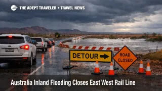
Australia inland flooding travel disruption widened on February 25, 2026, after the Australian Rail Track Corporation (ARTC) confirmed the East West rail corridor remains closed, with all rail services suspended while crews conduct recovery works near Port Augusta, South Australia. The operational change versus earlier updates is that ARTC is now actively in the rebuild phase while also flagging a fresh heavy rain window from Friday through Sunday that could slow repairs and extend the closure. For travelers, the immediate consequence is itinerary instability across inland routes that depend on predictable resupply and open highways, especially in outback South Australia and cross border corridors into the Northern Territory. For freight, the closure removes a key interstate rail option at the same time road networks are stressed, which can push delays downstream into regional provisioning and onward travel connections.
Australia Inland Flooding Travel Disruption: What Changed
ARTC's latest network update on February 25 says the East West corridor remains closed and all rail services are suspended, with crews and equipment mobilised on the ground near Port Augusta. ARTC also cautioned that another major rainfall event is forecast for Friday through Sunday, and that it could affect recovery works and reopening timeframes, a clear signal that the current plan is weather dependent rather than locked.
The most consequential detail for routing choices is where the rail damage sits. Earlier ARTC and ABC reporting tied the most significant washaways to the corridor between McLeay and Bookaloo in South Australia, and ARTC also indicated inspections across adjacent sections including Crystal Brook to Broken Hill, plus Port Augusta to Whyalla, to determine the full extent of impacts. ARTC's February 23 update added that the lines from Port Augusta to Whyalla, and from Port Augusta to Broken Hill, had reopened, but that restoration of the broader East West corridor was still expected to take longer than seven days.
On the road side, outback closures and restrictions are compounding the problem. Industry reporting on February 24 highlighted impacts to major freight and long distance driving routes including the Stuart Highway, Tablelands Highway, Tanami, Birdsville Track, and Strzelecki Track, with lingering water over road sections even where reopenings begin.
Which Travelers And Routes Face The Most Disruption
The highest risk travelers are those whose plans rely on a single long corridor staying open, including outback road trips, remote station stays, camping circuits, and small group tours that depend on fuel, food deliveries, and time specific meet points. In northern South Australia, ABC reporting described rapid rises at creek crossings and warnings against travel around Port Augusta and through areas such as Hawker and Quorn, a pattern that matters because a single cut point can force multi hour backtracks on sparsely serviced roads. The same reporting also flagged that communities along classic outback routes, including places such as Moomba, Innamincka, and Oodnadatta, can be cut off when creeks and waterways rise across the Birdsville Track region.
For cross border drivers and anyone moving through the Northern Territory, Road Report NT is the authoritative view of which government controlled roads are open, restricted, or closed, and it is especially important because conditions can change faster than general news coverage. In practice, even when a highway is technically open, water over road, damaged pavement, or pilot traffic controls can turn a nominal driving day into a fatigue and daylight problem.
In outback South Australia, the state's outback road warnings map is the decision tool that matters most before departure and at each morning go, because it consolidates closures, restrictions, and warnings, and it is updated as conditions change. The state also warns that some outback road signs may not automatically update due to satellite outage and flood damage, which is a quiet but important operational detail for travelers who normally rely on roadside messaging.
What Travelers Should Do Now
Travelers with inland driving legs should treat February 25, 2026, as a reassessment day, not a push through day. The immediate move is to check three sources in sequence, the Bureau of Meteorology flood watch for your catchment, South Australia's outback road warnings map if you are anywhere in the SA outback network, and Road Report NT if you touch Northern Territory roads, then decide based on what is open now, not what was open yesterday.
Re route when the detour turns your plan into long, late driving across low service roads, because that is where accident risk and fatigue spike. A practical trigger is any day where your safest available route forces you to arrive after dark, or where your next fuel point depends on a single crossing that is trending upward on flood advice. If your trip includes remote community stays, station experiences, or guided outback touring, postpone when your operator cannot confirm provisioning deliveries and a reliable extraction route, because supply chain delays and road damage can turn a normal inconvenience into a safety and medical access problem.
For rail dependent itineraries, assume that anything that depends on the East West rail corridor is operating on a rolling recovery timeline until ARTC confirms a return to service date that survives the next forecast rain window. If you are booking time sensitive tours or fixed date accommodation in inland regions that depend on regular freight replenishment, build extra slack into arrival days, and avoid tight same day connections between long drives and fixed check in times. The second order risk is not only that a road is closed, it is that food, fuel, and service staffing arrive late, which then degrades the traveler experience even when the hotel door is technically open.
Why The Disruption Spreads Through Travel
A persistent inland low can break travel systems in two linked ways. First, it physically removes corridor capacity, either by washing out rail formation and culverts, or by putting water across roads and closing creek crossings. ARTC's reporting points to track washaways between McLeay and Bookaloo, and its February 25 update makes clear the recovery plan is active but vulnerable to more rain through the weekend, which is exactly the pattern that creates reopen, reclose, and slow order cycles that frustrate both travelers and logistics planners.
Second, once primary corridors are constrained, traffic concentrates onto fewer alternates, which raises travel time variance. On roads, that means longer detours, more heavy vehicle mixing on secondary routes, and a higher chance that a single incident shuts the only viable path. On freight, rail holds and re-routing attempts can cascade into delivery delays for regional hotels and tour operators, especially in places that normally depend on just in time replenishment runs. ABC reporting also captured the on the ground reality that some outback crossings rise quickly, and that extraction can take 24 to 48 hours in worst cases, which is why the right traveler decision is often made before you commit to the next segment, not after you are already in it.
Sources
- Media Statement East West Rail Corridor Flood Impact, Network Update, Wednesday 25 February 2026 (ARTC)
- Media Statement East West Rail Corridor Remains Closed Following Weekend Flooding, Monday 23 February 2026 (ARTC)
- East West Rail Corridor Cut By Flooding Amid Heavy Rain In Northern SA (ABC News, February 22, 2026)
- Half The Country On Flood Watch As Summer Storms Bring Deluge Of Rain (ABC News, February 24, 2026)
- Flooding And Heavy Rain Closes Outback Roads And Highways (Big Rigs, February 24, 2026)
- Outback Road Warnings Map (SA Department for Infrastructure and Transport)
- Road Report NT (Northern Territory Government)
- Flood Watch IDS20374 (Bureau of Meteorology)