Hinchinbrook Flooding Closes Bruce Highway Near Ingham
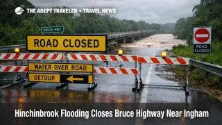
Hinchinbrook Bruce Highway flooding has moved from a wet season watch into a concrete route break on March 2, 2026, with the Department of Transport and Main Roads listing the Bruce Highway between Ingham and Cardwell as closed to all traffic due to flooding at the Seymour River. At the same time, the Hinchinbrook Local Disaster Management Group says access into the Lower Herbert area is now closed after both the Halifax Washaway and the Anabranch Bridge shut, which is the kind of paired closure that can strand travelers on the wrong side of lodging, tours, and onward flights. The Bureau of Meteorology major flood warning for the Herbert River system also flags that further rises remain possible with forecast rain, so reopening timelines are hard to bank on until water levels peak and begin a sustained fall.
One detail that matters for decision making is timing. The BOM warning describes expected peaks Monday afternoon to Monday evening at key gauges, including Halifax remaining in major flooding, and Gairloch and the Ingham Pump Station trending toward moderate flooding levels. Hinchinbrook's local notice also publishes modeled peak guidance and road impact thresholds for Taylors Beach Road and the Halifax to Lucinda Road, but the same notice contains an apparent year typo in the peak lines, listing "2 March 2025" while being issued March 2, 2026. Travelers should treat the direction of travel as the point, peaks expected Monday evening, not the specific year stamp in that one line.
Hinchinbrook Bruce Highway Flooding: What Changed
The change is that the closure is now named, active, and tied to specific river behavior, not just a forecast. QLD Traffic's Northern District report lists the Bruce Highway closure between Ingham and Cardwell due to flooding at the Seymour River, and marks it closed to all traffic. In parallel, the same official feed shows multiple supporting road closures around Ingham, Halifax, Bemerside, and nearby local routes, including the Halifax Washaway segment on the Ingham Halifax Road, and the Halifax Bemerside Road closure at the Anabranch Bridge.
For travelers, the practical consequence is that even "short" coastal moves can fail in an all or nothing way. When the trunk highway closes and local alternates are also underwater, there is often no workable detour that preserves same day check in, timed tours, or airport transfers, which is why this becomes an itinerary triage problem, not a slower drive.
Which North Queensland Travelers Are Most Exposed
Self drive travelers moving between Townsville, Australia and Cairns, Australia are the most exposed when they are counting on the Bruce Highway as a same day corridor. Once the Seymour River section is shut, the system does not degrade gracefully, it breaks, and the break tends to propagate into accommodation changes and missed bookings as people bunch into safer hubs.
The second high risk group is anyone with lodging, friends, work, or tours booked in the Lower Herbert area, including Halifax and Lucinda access roads, because the local disaster notice explicitly states access into the Lower Herbert is closed with the Halifax Washaway and Anabranch Bridge both shut. That closure pattern can trap travelers who already crossed earlier, and it can also prevent late arrivals from reaching paid stays. The more "fixed" your booking, a prepaid fishing charter, a boat ramp meet up, a day tour with a firm departure, the more likely it is that the right move is to pause outside the closure footprint rather than trying to thread around it.
A third exposure bucket is travelers holding tight onward connections from regional airports. The most common failure mode in this setup is not the flight itself, it is the transfer failing because road access collapses, then the traveler eats the cost of a missed sector or a forced extra night. ABC reporting on the situation also underscores that the Seymour River bridge was being managed tightly and could worsen with additional rain, which reinforces the "do not assume it will stay barely open" trap.
What Travelers Should Do Now
If you have not entered the closure zone yet, the simplest rule is to stop treating today as a normal drive day. Before you leave lodging, check the QLD Traffic listing for the Bruce Highway and for the specific local roads that connect you to your booked stay, because the closure list is being updated with time stamps and will often change faster than general media reporting. If the trunk route you need is marked closed to all traffic, do not plan around "maybe it opens later," instead, decide whether to reposition to the side of the trip that still works, or pause in a hub where you can extend safely.
A useful decision threshold is this. If you need to be somewhere for a flight, a cruise check in, or a non refundable start within the next 24 hours, and the only path depends on a flooded crossing or a closed highway segment, rerouting early is usually cheaper than waiting for a reopening that may not come before your deadline. If your plans are flexible and your next booking is not time critical, waiting can be the better trade, because reopening often requires both falling river levels and post flood safety checks, not just "rain stopped."
For people already in the Lower Herbert footprint, the priority shifts to documentation and containment. Take screenshots of the road closure notices and the flood warning pages, save lodging and tour communications, and message providers now about late arrival or inability to reach the property. This is also the window to add buffer nights in places that still have services, because the second order effect is inventory compression when everyone diverts to the same safer towns.
Why These Closures Can Persist After Rain Eases
The mechanism is river behavior plus a saturated network, not just one storm cell. The Bureau of Meteorology warning describes flooding states and expected peaks across the Herbert River gauges, and explicitly notes that further rises are possible with forecast rain. That matters because once a river system is elevated, a fresh burst of rainfall can extend closure duration even if the sky looks clearer for a few hours.
The second order effect is that road closures create concentration pressure. When the Bruce Highway segment is down, traffic that would normally spread across time and route options collapses into fewer safe nodes, which increases the odds of missed check ins, forced hotel extensions, and delayed resupply for smaller communities. Hinchinbrook Bruce Highway flooding is also a reminder that North Queensland's travel risk right now is a rolling window, not a single afternoon problem, which is why travelers should keep monitoring official feeds until water levels peak and fall consistently.
Sources
- Department of Transport and Main Roads, QLD Traffic, Northern District Road Report
- HLDMG Public Notice, Access to the Lower Herbert and Abergowrie Areas, Hinchinbrook Shire Council
- ABC Emergency, Major Flood Warning for the Herbert River
- ABC News, Queensland on cyclone watch as rain drenches parts of state