Central US Storms Threaten Flight Banks March 4 to 7
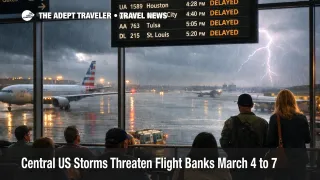
A multi day severe weather setup across the central United States is expected to pressure airline schedules from Wednesday, March 4, 2026, through at least Saturday, March 7, 2026, with thunderstorms capable of large hail, damaging winds, and a tornado risk in several waves. The travel consequence is not just a few delayed departures, it is the way storms break "banked" hub operations, the tightly timed arrival and departure waves that keep connections working at major airports. For March 4 specifically, NOAA's Storm Prediction Center (SPC) flags a Slight Risk stretching from north central and northeast Texas into the Lower Ohio Valley, with large hail, localized wind damage, and a tornado or two possible. The FAA's daily planning outlook also calls out thunderstorms as a potential disruptor for Dallas, which is a practical early warning that flow programs and gate congestion can follow if storms sit over the metroplex during peak push periods.
Central US Severe Storms Flight Delays: What Changed
The key change for travelers is that this is a forward looking disruption window with multiple "reloads," not a one afternoon thunderstorm day. SPC keeps a severe thunderstorm risk in place on Thursday, March 5, 2026, and then escalates to an Enhanced Risk on Friday, March 6, 2026, across parts of the southern and central Plains into the lower to mid Missouri Valley, with large hail, severe wind gusts, and tornadoes expected Friday into Friday night. In practical itinerary terms, that raises the odds that delays do not clear cleanly overnight, because aircraft and crews that finish late, or divert, often start the next day out of position, and the recovery tail can last longer than the storms themselves.
Which Itineraries Are Most at Risk
The highest exposure is any itinerary that depends on banked hub connections through Dallas Fort Worth International Airport (DFW) or George Bush Intercontinental Airport (IAH), because thunderstorms in that corridor tend to produce the exact operational mix that breaks tight connections, arrival acceptance cuts, ramp holds for lightning, and gate holds when arrivals stack. Even if your departure airport is clear, metering can push the delay upstream so the hub does not saturate, and that is how a clear sky origin becomes a late departure day.
A second exposure band is Plains and lower Midwest flying that relies on "thin" frequency markets, where there are fewer later flights to catch. That includes travel touching Will Rogers World Airport (OKC), Tulsa International Airport (TUL), and Kansas City International Airport (MCI), especially on Friday, March 6, 2026, when SPC explicitly describes a substantial severe threat that can extend north toward the Kansas City metro. If you miss the last reasonable connection in those markets, the most common outcome is an overnight plus a reflowed itinerary.
A third group is travelers stacking same day commitments behind an arrival, cruise embarkations, resort check ins with late cutoff transfers, or prepaid tours that cannot slide. This matters more right now because March demand is already high in several markets, and when storms force large same day reaccommodations, remaining seat inventory can disappear quickly. If your trip also intersects spring break volume, the compounding risk is higher, because rebooking competition is higher. For Houston specifically, this week already has volume pressure in the March 5 to March 16 window, which makes storm days harder to "solve" on short notice. See Houston Spring Break: IAH, HOU TSA Lines May Stretch.
How To Plan Around the Storm Window
Start by buying margin. If you are connecting through DFW, IAH, or the central Plains corridor, avoid sub 90 minute connections from Wednesday, March 4, 2026, through Saturday, March 7, 2026, because the failure mode here is not one big cancellation wave, it is rolling delays that erode connection buffers flight by flight. If your itinerary is on separate tickets, or you have a hard arrival requirement, treat a same day connection as a risk decision, not a default.
Set a decision threshold before the day of travel. Rebook earlier, or shift to a nonstop, if missing your planned arrival forces an overnight, breaks a cruise embarkation, or triggers expensive downstream losses. Waiting for waivers can save money, but it can cost the itinerary, especially when severe weather is forecast in multiple rounds and hubs cannot "catch up" between waves. The tradeoff is simple, rebook early while seat options exist, or wait and accept that your choices may narrow once flow programs and diversions begin.
Monitor the right signals in the 24 to 72 hours before departure. Track the SPC convective outlook level changes for your corridor, and then pair that with FAA operational status signals on the day, including airport status pages and the NAS status feed when programs activate. Your best early warning at the flight level is usually your inbound aircraft and crew assignment in the airline app, because once the inbound slips, your departure often follows.
Why Storm Days Break Flight Banks
Thunderstorms reduce usable runway and ramp throughput in two main ways. First, arrival spacing increases to maintain safety in convective weather, and that lowers the arrival rate even if the airport is technically "open." Second, lightning, hail, and wind gusts can pause ramp work, which slows turn times, holds bags, and creates gate conflicts as arriving aircraft cannot park on schedule. The FAA then uses traffic management tools to prevent an airport from saturating, which is why your origin can be delayed under clear skies, because it is being metered to protect the constrained destination.
The multi day aspect matters because recovery requires spare aircraft, spare crews, and spare gate time, and those buffers have been thinner in recent years. When storms hit during an afternoon or evening bank, the second order effect is often crew legality failures and aircraft rotations that cannot be rebuilt overnight, which turns Thursday's disruption into Friday morning cancellations, even if the morning looks quieter. For a deeper structural explainer on why system constraints make weather days feel sharper, see U.S. Air Traffic Control Privatization: Reality Check. For the most recent baseline on how FAA planning signals have been evolving this week, see Flight Delays and Airport Impacts: March 3.
Sources
- Storm Prediction Center Mar 4, 2026 1300 UTC Day 1 Convective Outlook
- Storm Prediction Center Mar 4, 2026 0700 UTC Day 2 Convective Outlook
- Storm Prediction Center Mar 4, 2026 0830 UTC Day 3 Severe Thunderstorm Outlook
- FAA Daily Air Traffic Report, Wednesday, March 4, 2026
- National Airspace System Status
- NWS Wichita Hazardous Weather Briefing Page