Hawaii Flood Watch Keeps Flight Risk for March 23
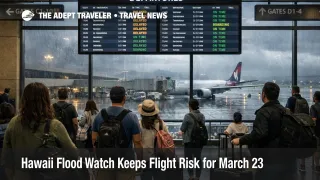
A Hawaii flood watch is still shaping March 23 travel decisions even though the state's airports remain open. Hawaii Tourism Authority guidance updated late Sunday said a flood watch remained in effect for Oahu, Maui County, and Hawaii Island through Monday, while travelers at high elevations on the Island of Hawaii also faced the possibility of heavy snow and strong winds. That keeps the main risk centered on timing, road access, and last minute flight disruption rather than a statewide airport shutdown. Travelers with Monday departures or inter island connections should keep carrier alerts on, reconfirm ground transfers, and build more buffer into airport runs.
Hawaii Flood Watch Flights: What Changed
The new element is not a broad closure order, but a narrower Sunday evening operating picture. GoHawaii's weather alert said conditions were gradually improving, flash flood warnings had been lifted, and airports remained open, but it also kept a flood watch in place for Maui County and Hawaii Island through Monday morning and urged visitors to monitor weather conditions closely. The National Weather Service Honolulu forecast discussion said the kona low was moving away, but a lingering moisture band and an approaching upper trough would keep enhanced showers and isolated thunderstorms in play into Monday morning, especially across Maui County and the Big Island, with Oahu still seeing some exposure.
That distinction matters for travelers because open airports do not mean normal operations. The Hawaii Tourism Authority told passengers to check directly with airlines, enable SMS and app notifications, arrive three hours before transpacific departures, and arrive 90 minutes before inter island departures. That is a practical signal that the state expects irregular operations risk to remain real even as the storm starts to weaken.
The weather system behind the disruption is a kona low, a winter storm pattern that pulls moisture into Hawaii from the south or southwest. In plain travel terms, that setup can produce intense rain over already saturated ground, which shifts disruption from just weather in the sky to slower roads, localized flooding, harder airport access, and weaker recovery if one delayed segment breaks a larger itinerary. Associated Press reporting described the flooding as Hawaii's worst in more than 20 years, with large scale rescues, evacuations, infrastructure damage, and continuing localized impacts even as the worst conditions begin to ease.
Which Hawaii Travelers Face the Most Friction
The most exposed travelers are those moving through Oahu, Maui County, and Hawaii Island on March 23, especially anyone relying on same day inter island links, tight connections, or long road transfers before check in. The risk is highest where weather and ground conditions overlap, not only where aircraft are scheduled to fly. North Shore Oahu remains a special case, with GoHawaii advising visitors to avoid the area until further notice because of excessive flooding, even as much of the island remains open.
Travelers headed to Maui County and Hawaii Island face a slightly different problem. The heaviest rain and possible thunderstorms were focused there in the latest tourism guidance, and the National Weather Service continued to warn of heavier showers across those areas into Monday. On the Big Island summits, winter storm conditions also remained possible or active at high elevations, which matters less for airport operations directly and more for road safety, tour plans, and the broader reliability of mountain area movement.
Kauai looks better than it did earlier in the event. GoHawaii no longer lists a flood watch there, which means the traveler exposure is no longer statewide in the same way. That is useful for visitors deciding whether to postpone an entire Hawaii trip, because the problem has narrowed into island specific friction rather than a uniform statewide stop signal.
What Travelers Should Do Before Monday Flights
The immediate move is simple. Keep the trip, but manage it like a live weather disruption instead of a routine departure day. For Monday flights, travelers should follow Hawaii Tourism Authority guidance by checking the carrier directly, turning on app and text alerts, and using the longer airport arrival windows the agency published. Those buffers are especially important for transpacific departures, for inter island trips that feed a long haul leg, and for anyone coming from areas with recent road flooding.
The next decision point is ground transport, not just the boarding pass. Rebook or reroute ground transfers if the hotel, vacation rental, or sightseeing plan sits in an area that has seen flooding, runoff, or road restrictions. On Oahu, that includes travelers who planned to use the North Shore as part of an airport transfer day. On Maui and Hawaii Island, it means checking whether the route to the airport still makes sense under current conditions, rather than assuming the map time will hold.
Waiting can still be the right move if your airline has not touched the schedule and your route to the airport is clear. Rebooking becomes more sensible when the itinerary depends on a short inter island connection, a nonrefundable same day tour, or a late arrival into a weather exposed area. The main threshold to watch is whether localized flooding, thunderstorms, or road issues start to compress the time you need to get to the airport. For Hawaii flood watch flights, the trip is still viable, but tight timing is the weak point.
Why the Kona Low Still Matters on March 23
The system is weakening, but the recovery phase is not the same as an all clear. The National Weather Service said the kona low was moving away to the northeast, yet lingering moisture and an upper trough would keep showers and some thunderstorms in the picture into Monday before drier weather gradually takes over. That means the first order threat is easing, but second order effects can continue after the peak rainfall passes. Roads can remain vulnerable, soils stay saturated, and airlines may still need to work through delays or crew and aircraft positioning problems created during the worst part of the storm.
That also explains why Hawaii officials are still telling travelers not to cancel trips outright. The state remains open for visitors, and the broad message from tourism officials is that conditions are improving rather than worsening. Still, improving is not the same as normal. For March 23, the practical read is that Hawaii flood watch flights remain bookable and airports remain open, but travelers should plan for uneven conditions by island and be ready for delay driven itinerary changes before the situation settles more fully later in the week.