Kenya Floods Cut Kisumu Road Links This Week
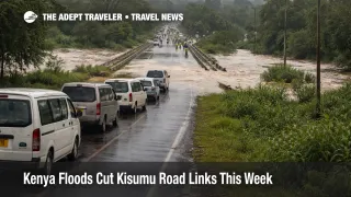
Heavy flooding in Kenya has moved from a weather problem into a transport planning problem for travelers using western Kenya road links this week. On March 24, 2026, Associated Press reported that the Nyando River submerged parts of Ahero Bridge on the Kericho to Awasi to Kisumu road, while Kenyan authorities warned motorists to stay off flooded sections and use alternate routes. For travelers, that changes how to build airport runs to Kisumu, regional road transfers, and any itinerary that assumed a straightforward drive into Kisumu from the highlands.
Kenya Floods Kisumu Road Disruption: What Changed
The immediate change is concentrated at Ahero Bridge, where River Nyando overflow has disrupted the Kericho to Awasi to Kisumu corridor, one of the key western Kenya approaches into Kisumu. Secondary reporting citing government direction says traffic to and from Kisumu is being redirected through the Timboroa to Lesos to Kapsabet to Chavakali route while conditions remain unsafe on the flooded stretch. Kenya Meteorological Department advisories had already warned that heavy rainfall would intensify across western Kenya through March 24, which helps explain why this has become a live routing issue rather than an isolated flooded roadside segment.
This is operationally meaningful because the closure does not just affect local traffic. It hits the road layer that feeds Kisumu bound business trips, regional visits around Lake Victoria, and surface transfers that connect with Kisumu International Airport (KIS). A normal Kericho to Kisumu Airport drive is roughly 87 kilometers and about 1 hour 15 minutes, so a forced diversion can turn a manageable same day airport transfer into a much looser, buffer heavy move.
Which Kenya Itineraries Are Most Exposed
The most exposed travelers are those trying to reach Kisumu by road from Kericho and nearby western highland points, along with operators running fixed ground transfers into Kisumu hotels, port areas, or the airport. Safari travelers using western Kenya as a regional transit leg are also vulnerable if they had planned same vehicle movements without slack in the schedule. The problem is not that every western Kenya road is closed, it is that one important corridor is unreliable enough that travelers should stop treating the direct route as the default.
The next layer of exposure is lodging and local movement. AP reported more than 21 counties affected nationwide and more than 34,000 people displaced, while flooding in Uasin Gishu County along the Sosiani River has affected residential and hospitality facilities. That does not automatically mean hotels are broadly shut across Eldoret, but it does mean travelers should assume patchy property level disruption, slower local access, and last minute room reshuffling in flood exposed areas rather than normal check in conditions.
What Travelers Should Do Now
Travelers with a March 24 to March 27 ground transfer into Kisumu should rebuild the plan around a reroute immediately, not at departure time. If the trip includes Kisumu International Airport (KIS), a ferry connection on Lake Victoria, a medical appointment, a tour departure, or a same day business meeting, the safer assumption is that the direct Kericho to Awasi to Kisumu run is off the table until authorities say otherwise. Ask your driver, hotel, or tour operator to confirm the exact road they intend to use, and reject vague assurances that they will "check on the way."
The main decision threshold is time sensitivity. If missing the day's purpose would materially damage the trip, switch to the alternate routing now and add substantial daylight buffer. If your plan depended on a tight airport transfer or a same day out and back by road, it is smarter to reschedule, overnight closer to Kisumu, or move to a flight based solution where available. Authorities have specifically warned motorists away from flooded areas, especially at night, so travelers should avoid any operator proposing a dark hours crossing on a road section already under warning.
Over the next 24 to 72 hours, the signals that matter most are simple. Watch for any official notice that the Ahero Bridge stretch has reopened normally, check whether rainfall warnings for western Kenya are extended, and confirm whether your hotel or transport provider is dealing with its own access or staffing disruption. Until those signals improve, the practical posture for western Kenya road travel is to treat direct Kisumu access from the flooded corridor as fragile, and to build the trip around reroutes, extra time, and flexible arrival commitments.
Why the Flooding Is Spreading Through Travel Plans
The mechanism here is straightforward. Kenya's long rains season was already forecast to bring near average to above average rainfall to the Lake Victoria Basin and western parts of the country, and the March 19 to March 24 heavy rainfall advisory specifically pointed to intensified rain in western Kenya. Once rivers like the Nyando overtop near a bridge or low lying road segment, the disruption spreads outward fast, first into direct road closures, then into longer diversions, then into missed airport runs, delayed hotel arrivals, tour compression, and higher pressure on whatever substitute corridors remain open.
That is why this week's Kenya flooding is more serious for travelers than a generic rainy season headline. The first order effect is an unsafe road segment near Ahero. The second order effect is network stress across western Kenya ground transport, including Kisumu access and flood spillover in places like Uasin Gishu. What happens next depends mostly on rainfall persistence and river levels. AP reported that officials remain on alert and warned conditions could worsen if heavy rains continue, so travelers should plan for instability first, and normalization second.
Sources
- Kenya floods worsen as 2 rivers burst banks, with death toll hitting 88
- Heavy rainfall advisory 18_3_2026
- Technical Statement From the Twelfth National Climate Outlook Forum, NCOF12
- Government issues alert as River Nyando floods Ahero Bridge
- Red Cross leads evacuations as River Nyando breaks its banks
- Flood alert: Govt lists Kisumu, Tana River and Uasin Gishu among counties at risk
- Driving directions to Kisumu International Airport (KIS)
- Kericho to Kisumu Airport (KIS)