2025 Atlantic Hurricane Season: NOAA Warns of Strong Storms
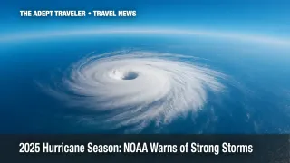
The 2025 Atlantic hurricane season officially began on June 1, and government scientists are already urging travelers and coastal residents to prepare. A new outlook from the National Oceanic and Atmospheric Administration (NOAA) gives the season a 60 percent chance of above-normal activity, with as many as 19 named systems and up to five Category 3 or stronger hurricanes. Warm ocean temperatures, a weakening El Niño, and a possible northward shift of the West African monsoon all raise the risk that one of those storms could be record-setting.
Key Points
- NOAA sees 60 percent odds of an above-normal season.
- Up to 19 named storms forecast, including five major hurricanes.
- Warm Atlantic waters and shifting monsoon may fuel long-lived storms.
- Travelers should review insurance and stock emergency supplies now.
2025 Atlantic Hurricane Season Outlook
Forecasters determined that sea-surface temperatures across the tropical Atlantic are running roughly one to two degrees Fahrenheit above the 30-year average. That extra heat acts as high-octane fuel for developing storms, allowing them to intensify rapidly and maintain strength longer over open water. At the same time, wind shear-upper-level winds that normally tear systems apart-is expected to remain near or slightly below average, giving storms a clearer path to build towering, organized cores.
"This hurricane season also features the potential for a northward shift of the West African monsoon, producing tropical waves that seed some of the strongest and most long-lived Atlantic storms," NOAA scientists noted in the report.
What Makes the 2025 Atlantic Hurricane Season Different?
A cluster of climate signals is converging. First, the current El Niño event is fading, and neutral conditions tend to favor Atlantic storm formation. Second, the Multidecadal Atlantic Oscillation remains in a positive-or warm-phase, keeping background sea-surface temperatures higher than normal. Finally, Saharan dust concentrations, which can suppress formation by drying out the mid-troposphere, are forecast to be intermittent rather than persistent this summer.
Names to Watch
NOAA's list begins with Andrea, Barry, and Chantal, followed by Dexter, Jerry, Karen, Van, and Wendy. Names recycle every six years unless a storm is so destructive that it is retired, meaning at least a half-dozen new names could enter the record books by November 30.
Preparation Guidance for Travelers
Rick Knabb of The Weather Channel reminds viewers to stock "one gallon, per person, per day, for as much as seven days" of potable water. In addition to water, experts recommend non-perishable food, pet supplies, flashlights, backup power banks, and extra prescription medication. Travelers visiting hurricane-prone destinations should secure Cancel For Any Reason coverage through a reputable travel insurance guide before storms threaten. Those living on the coast can download NOAA's free storm-surge maps and sign up for local alerts through the agency's hurricane center.
Evacuation and Shelter Logistics
Know your evacuation zone, plan multiple routes inland, and verify that your destination can accept pets if you are traveling with animals. Shelters often require government-issued ID and personal bedding. Keep hard copies of itineraries, insurance documents, and medical prescriptions in a waterproof pouch. A printable hurricane preparedness checklist helps ensure nothing critical is forgotten. The American Red Cross offers an updated list of open shelters and safety tips on its website, while NOAA's mobile app pushes location-based warnings in real time.
Analysis
The 2025 outlook is a stark reminder that a single storm can derail travel plans and devastate coastal infrastructure, even in a statistically average year. Airlines typically waive change fees only after watches or warnings are issued, by which point seats on alternative flights are scarce. Cruise lines may reroute ships or cancel sailings entirely, leaving travelers scrambling for hotel rooms inland. Travel advisors are urging clients to build flexibility into summer and fall itineraries, avoid tight connection windows through exposed airports, and consider shoulder-season trips to regions outside the Atlantic Basin.
Insurance underwriters could recalibrate premiums upward if early storms verify NOAA's warmer-than-normal sea-surface analysis. Higher deductibles are likely in Florida, the Carolinas, and the Gulf Coast, where past landfalls continue to drive rebuilding costs. Meanwhile, hospitality operators are fine-tuning continuity plans-stockpiling generators, reinforcing critical infrastructure, and training staff on shelter-in-place protocols-to reassure guests. For travelers, understanding these mitigations and choosing properties that demonstrate robust storm plans may provide an extra layer of confidence.
Final Thoughts
While the headline numbers suggest an active stretch ahead, the takeaway is straightforward: it only takes one landfalling hurricane to upend lives and vacations. By monitoring official advisories, maintaining a well-supplied emergency kit, and securing flexible reservations, travelers and residents alike can blunt potential impacts. Stay alert, stay prepared, and treat each update during the 2025 Atlantic hurricane season as an opportunity to refine your readiness plans.