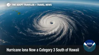
Hurricane Iona Now a Category 3 South of Hawaii

Hurricane Iona has rapidly intensified into a major Category 3 storm in the central Pacific, packing sustained winds near 115 mph about 790 miles south-southeast of Honolulu. The system is tracking west over open water and, for now, poses no direct threat to land. However, long-period swells generated by the hurricane are expected to reach Hawaii's south-facing shores later this week, raising surf heights and the risk of coastal flooding. Travelers planning inter-island flights should consider flexible, change-friendly fares in case weather-related disruptions emerge.
Key Points
- Why it matters: Swells from a distant major hurricane can still snarl air and sea travel around Hawaii.
- No coastal watches or warnings in effect, per the Central Pacific Hurricane Center.
- South-shore surf likely to reach advisory levels by Thursday-Friday.
- Inter-island flyers should book tickets that allow fee-free changes or standby rebooking.
Snapshot
Forecasters at the Central Pacific Hurricane Center report Iona's central pressure near 962 mb, with hurricane-force winds extending 25 miles from the eye and tropical-storm-force winds reaching 115 miles. The storm is cruising west at roughly 13 mph and is expected to remain on a westward track well south of the Hawaiian archipelago through at least Friday. Computer models show gradual weakening late week as Iona encounters cooler sea-surface temperatures. Even so, deep-water swells radiating northward will build surf to 6-10 feet along south-facing shores from Kauai to the Big Island, peaking Thursday night into Friday.
Background
July begins the climatological peak of the central-Pacific hurricane season, when warm waters south of Hawaii can spin up powerful cyclones. While most major storms stay well away from the islands, their wave energy often arrives days later, flooding low-lying roads and disrupting small-craft operations. In 2023 Hurricane Dora followed a similar path and produced record south-shore surf, illustrating how even remote hurricanes can upend travel plans. Hawaii's inter-island air network is particularly sensitive to weather: high surf can close coastal highways leading to airports, and gusty convective squalls on a hurricane's northern fringe may prompt last-minute flight delays. Earlier this week, Adept Traveler covered Iona's transition from tropical storm to hurricane, underscoring the storm's fast-paced evolution.
Latest Developments
South-Shore Surf Set to Build
Wave-model guidance shows Iona's 15- to 17-second swells arriving on Wednesday night, climbing to warning thresholds-possibly 12 feet-by Thursday afternoon. The National Weather Service expects hazardous rip currents and minor overwash of shoreline roads at high tide. Beachfront resorts from Waikīkī to Poʻipū are preparing to deploy sand berms and reroute pedestrian traffic. Airlines, led by Hawaiian Airlines, have yet to post formal travel waivers, but agents advise purchasing main-cabin economy fares that allow same-day confirmed changes without penalties. Travelers holding non-refundable "basic" tickets may face fees if surf-related disruptions force itinerary shifts. Those connecting to the mainland should allow extra layover time at Daniel K. Inouye International Airport (HNL) in case inter-island legs slip off schedule.
Analysis
Hawaii's compact geography makes it uniquely vulnerable to secondary hurricane impacts. Even without landfall, Iona's swells will arrive during a period of spring-high tides, amplifying shoreline flooding potential. Rental-car shortages on neighbor islands mean that a sudden influx of stranded passengers can overwhelm limited inventories, driving prices higher. Travelers who lock in refundable hotel rates and roadside-assistance packages now will have more options if highways such as Honoapiʻilani on Maui or Kamehameha Highway on Oʻahu experience salt-water pooling. Air carriers typically issue voluntary change waivers once the National Weather Service posts a High Surf Warning; such advisories may come 24-36 hours before peak surf. Booking early-morning flights reduces exposure to afternoon sea-breeze-enhanced showers that, when combined with hurricane-driven moisture, can slow ground operations. Travelers should also monitor Tropical Storm Keli trailing Iona; although weaker, its eventual swell train could extend the period of rough seas into early next week, prolonging logistical challenges for island-hoppers, cruise-ship tenders, and shipping barges supplying essential goods. By planning for flexibility-selecting tickets with free same-day changes, confirming hotel cancellation windows, and arranging travel insurance that covers weather-visitors can stay nimble while enjoying Hawai'i's natural beauty.
Final Thoughts
For the moment, Hurricane Iona remains a remote spectacle on satellite imagery, yet its wave energy will make a tangible appearance on Hawai'i's south shores within days. Travelers who build cushion into flight plans and opt for change-friendly fares will be best positioned to adapt should surf-related delays arise. Stay informed, stay flexible, and let prudent preparation keep your island journey on track-even with Hurricane Iona lurking over the horizon.
