FAA Daily Air Traffic Report, August 3, 2025: Storm Delays
The Federal Aviation Administration's morning operations plan warns that summer thunderstorms could force pop-up ground stops from Denver to Miami, and runway projects continue to pinch capacity at several busy hubs. Although Saturday's flash flood chaos in the Northeast is easing, residual crew and aircraft mis-positions are keeping rebooking lines long. Travelers should expect rolling schedule changes throughout the day and monitor airline alerts closely.
Key Points
- Why it matters: Thunderstorms threaten to snarl the nation's busiest flight corridors during peak-season traffic.
- Travel impact: Possible ground stops at Denver, Seattle, San Francisco, and multiple Florida airports after 1500 Z.
- What's next: FAA will update its plan at 1315 Z and may add flow programs if convective cells intensify.
Snapshot
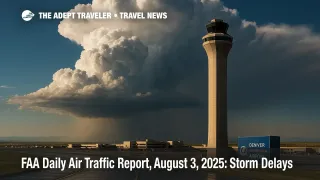
As of 8 a.m. Eastern, the Air Traffic Control System Command Center lists thunderstorms as the main constraint at Denver, Orlando, Tampa, Fort Lauderdale, Miami, and West Palm Beach. The agency also flags Gulf over water route closures, meaning transcontinental jets may need longer, fuel heavy detours. Winds could buffet Las Vegas later this afternoon. Meanwhile, Denver International has already logged more than 400 delays and ten cancellations, according to FlightAware data cited by CBS News Colorado. Across the network, crews are still catching up after Friday's and Saturday's flash floods in the Northeast.
Background
The FAA's Daily Air Traffic Report aggregates planned initiatives, ground stops, and flow programs to help airlines stage aircraft and crews. During summer, convective storms are the leading cause of departure holds, outranking low clouds and wind. A single thirty minute ground stop at a hub like Hartsfield-Jackson Atlanta International Airport (ATL) can cascade into hours-long delays at spoke cities. Airline recovery is further hampered this year by slim reserve staffing, ongoing controller shortages at New York TRACON, and runway construction at major airports, including Newark Liberty International Airport (EWR) and Chicago O'Hare International Airport (ORD).
Latest Developments
Florida under afternoon thunderstorm watch
The FAA plan calls for "possible ground stop after 1900 Z" at Miami, Fort Lauderdale, West Palm Beach, and Orlando. Embedded storm cells along the Gulf Coast are already forcing Q and Y route closures, pushing east-west traffic south toward the Caribbean or north along the Ohio Valley. Airlines have pre-emptively filed alternative routings that add 15-25 minutes of block time, and ramp crews are bracing for lightning pauses that halt baggage and fueling.
Denver ground stop kicks off busy Sunday
Shortly before 3 p.m. MDT Saturday, the FAA issued a wind shear ground stop at Denver International; by early Sunday the airport still showed hundreds of residual delays and ten cancellations. Although the formal hold has lifted, the Command Center warns that additional Coded Departure Routes or SWAP programs could return after 2200 Z if storm bands redevelop over the Front Range. Travelers connecting through Denver should leave extra time between flights and keep an eye on gate changes.
Analysis
Today's advisory illustrates a classic summer pinch: scattered convective weather across multiple Air Route Traffic Control Centers spreads controllers thin just as vacation travel peaks. When thunderheads pop over Denver, that isolates an essential Rocky Mountain waypoint, pushing Midwest-West Coast flights into longer arcs through Salt Lake City or Albuquerque airspace. Simultaneously, Florida thunderstorm clusters can choke the Southeast corridor, forcing high-volume carriers like Delta and American to juggle spare crews that were already stretched by Friday's East Coast flooding. The FAA's strategic use of time staggered "possible" ground stops buys flexibility, yet airlines often respond conservatively, pre-canceling flights to protect later bank integrity. Passengers benefit most by enrolling in mobile push alerts and checking the FAA's NAS Status map before leaving for the airport. A portable charger and carry-on essentials remain the best hedge against overnight misadventures.
Final Thoughts
The next FAA planning webinar at 1315 Z will clarify whether Florida storms or Rocky Mountain convection become the day's headline disruptors. Either way, Sunday travelers should brace for rolling holds, pack patience, and refresh airline apps frequently to stay ahead of any last-minute gate changes flagged in the FAA Daily Air Traffic Report.