Tropical Storm Ivo Intensifies Near Baja
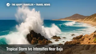
Tropical Storm Ivo continued to strengthen early August 8, 2025, with maximum sustained winds near 60 mph and rapid west-northwest motion south of Baja California Sur, according to the National Hurricane Center. Forecasters say Ivo could briefly reach hurricane strength later today or tonight before weakening this weekend as it passes well south of the peninsula. Hazardous surf and rip currents are spreading north along Mexico's Pacific coast, and Mexico's port authority has restricted small-craft operations at Manzanillo as swells build. Travelers headed to Cabo and Puerto Vallarta should plan for beach closures and intermittent flight delays.
Key Points
- Why it matters: Ivo's quick intensification raises short-term safety risks along popular Mexico beach corridors.
- Travel impact: Dangerous surf, rip currents, and localized flooding, with small-craft limits at Manzanillo reported.
- What's next: NHC expects a peak near hurricane strength today, then weakening over cooler waters this weekend.
- Peak hazards today from Guerrero to Baja Sur, with improving conditions late weekend.
- Watch for beach red flags and possible schedule changes for excursions and boat tours.
Snapshot
At 2 a.m. MST, Ivo was about 180 miles south-southeast of the Baja California Sur tip, moving west-northwest near 21 mph. The storm's compact wind field and fast motion mean impacts will be intense but brief along parts of Mexico's southwest and central Pacific coast. Swells and surf are the primary threats, with rip currents, coastal inundation in low-lying spots, and locally heavy rain. Ports and marinas from Colima to Jalisco are restricting small craft where seas are highest. Air travelers headed to Los Cabos International Airport (SJD) and Licenciado Gustavo Díaz Ordaz International Airport (PVR) should monitor airline alerts for weather-related delays.
Background
Eastern Pacific tropical activity typically peaks in August and September. Storms that form off southern Mexico often track west or west-northwest, remaining offshore while sending powerful swells toward resort areas from Guerrero to Baja California Sur. Ivo fits that pattern, with the National Hurricane Center calling for short-term strengthening over warm water and light shear, followed by weakening as the storm encounters cooler water and drier air. Mexico's meteorological agencies warn that dangerous surf and rip currents can extend far from a cyclone's center, even when no landfall is expected. Travelers should heed beach flags, follow lifeguard guidance, and avoid entering the water during high-risk periods.
Latest Developments
NHC intensity outlook points to a brief peak
Forecasters held Ivo's early-morning intensity near 60 mph and noted a growing central dense overcast on satellite imagery, a sign of strengthening. The official forecast calls for Ivo to become a hurricane within about 24 hours as its forward speed starts to ease, followed by steady weakening over cooler water through the weekend while it stays well south of Baja California Sur. Read the latest NHC public advisory for precise track, wind radii, and hazard statements: https://www.nhc.noaa.gov/archive/2025/ep09/ep092025.public.007.shtml?utm_source=adept.travel.
Ports and beaches feel the swell
Mexico's Pacific coast is already seeing hazardous surf. Authorities report partial closure at Manzanillo to small craft as swells increase, and beach communities from Jalisco to Nayarit are warning of rip currents and localized flooding in low-lying areas. If you have fishing charters or boat tours today, confirm status directly with operators before heading to the pier. Local details from Colima and Jalisco outlets are here: https://www.informador.mx/jalisco/Tormenta-tropical-Ivo-asi-afectara-a-Jalisco-Nayarit-y-Colima-20250808-0029.html?utm_source=adept.travel.
Rains and rough surf expand north
As Ivo parallels the coast, rain bands may bring brief downpours, lightning, and gusty squalls to resorts along the southwest coast. Forecasters also expect hazardous surf and rip currents across exposed beaches, even where skies are partly sunny between squalls. Broader context from wire reporting, including rainfall expectations and coastal hazards, is available here: https://apnews.com/article/908a295121cc211cf6535bd20bc975fd?utm_source=adept.travel.
Analysis
For travelers, the highest immediate risks are surf, currents, and localized flooding, not wind. Expect intermittent red-flag closures at popular beaches, especially those exposed to open Pacific swell. Shore excursions involving small boats, snorkeling, or diving are the most likely to be canceled or rescheduled on short notice. Harbors may limit departures for small craft, and piers can close temporarily during peak surf. Flight operations at Los Cabos International Airport (SJD) and Licenciado Gustavo Díaz Ordaz International Airport (PVR) generally continue in these setups, but bursts of convection near the terminals can push minor delays, especially on afternoon departures. Cruise calls at Cabo San Lucas often rely on tenders; heavy swell can complicate tendering even with offshore tracks, so guests should watch for last-minute adjustments. Plan conservatively, keep devices charged, and build extra time into transfers. Above all, follow local guidance, avoid entering rough water, and respect beach closures until lifeguards signal an all-clear.
Final Thoughts
Ivo looks like a fast-moving, short-fuse event. The combination of building swell, rip currents, and squally downpours can disrupt beach plans and small-boat activities today, with gradual improvement through the weekend as the storm weakens over cooler water. If you are headed to Baja California Sur or the Jalisco coast, stay flexible, watch official updates, and prioritize safety at the shoreline. We will update this brief as new advisories post on Tropical Storm Ivo.
Sources
- Tropical Storm Ivo, Public Advisory 7, National Hurricane Center
- Tropical Storm Ivo, Discussion 7, National Hurricane Center
- La tormenta tropical Ivo avanza con intensidad, El País México
- Conagua advierte sobre Ivo y cierre parcial a embarcaciones menores en Manzanillo, El Informador
- Tropical Storm Ivo forms, AP News