Tropical Storm Ivo Tracks West, Dexter Fades Out
At 2:00 a.m. MST on August 9, 2025, Tropical Storm Ivo continued west in the Eastern Pacific with maximum sustained winds near 60 mph, centered about 225 miles southwest of the southern tip of Baja California. The National Hurricane Center expects gradual weakening through the weekend, with Ivo likely becoming post-tropical by Sunday night. Swell from the storm will raise surf and rip-current risk along the southern Baja California peninsula. In the Atlantic, Dexter has transitioned to a post-tropical gale and is moving away over the North Atlantic, prompting a final NHC advisory.
Key Points
- Why it matters: Elevated surf and rip currents for southern Baja beaches through the weekend.
- Travel impact: Possible beach closures, red flags, and small-craft advisories along exposed coasts.
- What's next: Ivo weakens and becomes post-tropical by late Sunday.
- Dexter is a post-tropical gale, well away from land.
- No coastal watches or warnings are in effect for Mexico.
Snapshot
Tropical Storm Ivo is on a westward track well offshore of Pacific-Mexico. At 2:00 a.m. MST, the storm held 60 mph winds and a compact wind field, with tropical-storm-force winds extending only about 35 miles from the center. There are no coastal watches or warnings for Mexico, but the National Hurricane Center cautions that swell will affect the southern Baja California peninsula, producing dangerous surf and rip currents through at least Sunday. Forecast guidance calls for steady weakening as Ivo moves over cooler water and drier air, with a transition to a post-tropical system by Sunday night. In the Atlantic, Dexter has lost tropical characteristics and continues east-northeast over open water with no land hazards.
Background
Eastern Pacific tropical cyclones frequently track west or west-northwest away from mainland Mexico, weakening as they encounter cooler water and stable air. Even without a landfall, these systems can generate long-period swell that elevates surf and rip-current risk along Baja's open-ocean beaches. The NHC highlights this hazard in its public advisories, noting that swells from Ivo will continue to affect the southern Baja California peninsula. Separately, Dexter formed earlier this week in the Atlantic, passed northeast of Bermuda, then moved over cooler waters and merged with a frontal zone, a common pathway to extratropical transition in the mid-latitudes. The NHC issued its final advisory on Dexter on Thursday, emphasizing there were no coastal watches or warnings associated with the system. For travelers, the practical effects are beach safety and small-craft considerations rather than flight or port closures at this time.
Latest Developments
Ivo westbound with 60 mph winds
As of the 200 a.m. MST advisory, Ivo was located near 20.6 North, 112.4 West, moving west at 9 mph with maximum sustained winds near 60 mph and higher gusts. Tropical-storm-force winds extended about 35 miles from the center. The NHC expects gradual weakening over the next few days, with a post-tropical phase by Sunday night, and no coastal watches or warnings are in effect. Travelers in southern Baja should monitor local beach safety notices, as swell and rip currents will be the primary hazards. See the latest NHC bulletin for details plain-text advisory page (https://www.nhc.noaa.gov/text/refresh/MIATCPEP4+shtml/090839.shtml?utm_source=adept.travel).
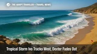
Swell and surf hazards for southern Baja
Marine guidance indicates 8 to 9 foot seas in the regional swell field, with additional southerly swell merging into the area. Seas and surf are expected to slowly subside into early next week as Ivo weakens and moves farther west-northwest, with the center projected near 21.7 North, 117.1 West by Sunday afternoon and near 22.0 North, 119.3 West by late Sunday night. Beachgoers should heed local flag systems and lifeguard direction, and mariners in small craft should exercise caution. Read the Eastern North Pacific Tropical Weather Discussion for timing and marine details (https://www.nhc.noaa.gov/text/refresh/MIATWDEP+shtml/091036_MIATWDEP.shtml?utm_source=adept.travel).
Dexter exits as a post-tropical gale
In the Atlantic, Dexter completed extratropical transition on Thursday. At 11:00 a.m. AST, the post-tropical cyclone was a storm-force low near 41.4 North, 50.4 West, moving east-northeast at 17 mph with maximum sustained winds near 60 mph. The NHC issued its final advisory on the system, and no coastal watches or warnings were in effect. While Dexter may continue to produce gale-force winds over open waters, it poses no direct travel impacts to North America. See the final public advisory here (https://www.nhc.noaa.gov/text/refresh/MIATCPAT4+shtml/071448.shtml?utm_source=adept.travel).
Analysis
From a travel perspective, Ivo's compact wind field and offshore track reduce the risk of widespread transportation disruption in Mexico. However, long-period swell can still create hazardous conditions at popular beaches in Los Cabos and along the southern Baja coastline. Expect red-flag days, intermittent beach access restrictions, and cautionary guidance from lifeguards, especially on exposed shores. Small-craft operators, snorkel excursions, and near-shore tours may face choppy conditions, brief cancellations, or revised itineraries until seas ease.
Air service typically continues normally during offshore Eastern Pacific storms of this type, since the main hazards are marine and coastal rather than wind or rain over airports and highways. Cruise ships transiting the Baja coast often adjust speed or distance to moderate swell when practical, but significant itinerary changes are uncommon when a system weakens and tracks away. The latest NHC forecast supports a steady decline in Ivo's intensity, with a post-tropical transition by late Sunday, which should allow surf to gradually subside early next week.
In the Atlantic, Dexter's extratropical status and distance from land remove meaningful travel impacts. For planners and advisors, the watch items now are localized surf hazards in Baja, brief marine-tour adjustments, and continued monitoring of routine NHC outlooks for any new disturbances. As always, travelers should follow local safety messaging before entering the water, even when the weather appears fair.
Final Thoughts
All signals point to a low-impact scenario for transportation, with the greatest concerns limited to surf and rip currents in southern Baja. Expect gradually improving marine conditions as Ivo weakens and shifts farther west-northwest into cooler water. Keep an eye on local advisories and obey beach flags, since long-period swell can be deceptive even on sunny days. With Dexter now out of the picture as a post-tropical gale, attention remains on the Eastern Pacific. We will continue to track changes, but for now the primary story is coastal surf safety linked to Tropical Storm Ivo.