Hurricane Henriette stays north of Hawai'i
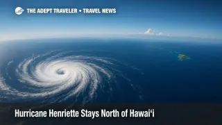
Hurricane Henriette is moving northwest well north of Hawai'i, with maximum sustained winds near 80 mph and no coastal watches or warnings in effect. The Central Pacific Hurricane Center says the small hurricane will remain over open water, with some additional strengthening today followed by weakening Tuesday. Air and cruise operations across the islands should continue normally, though travelers should monitor official updates and be mindful of surf along select shores. This brief explains the latest track, surf outlook, and smart steps for Hawaii travel and travel insurance.
Key Points
- Why it matters: Henriette poses no direct land threat to Hawai'i, limiting disruption to Hawaii travel.
- Travel impact: No watches or warnings; modest east-shore swell and existing south-shore surf advisory continue.
- What's next: Gradual weakening expected Tuesday as the system remains over open water.
- Surf note: East-facing shores see Henriette-related swell, while north and west remain small; south shores elevated from a separate long-period swell.
- Insurance tip: Travel insurance generally must be purchased before a storm is named to cover hurricane-related claims.
Snapshot
As of late Sunday night in Hawai'i, Hurricane Henriette was located about 470 miles north-northeast of Honolulu and moving northwest at around 17 mph. The hurricane's wind field is compact, with hurricane-force winds extending roughly 15 miles from the center, and forecasts keep the system far from the islands with no watches or warnings. For Hawaii travel, that means typical flight and cruise operations should continue, subject to routine schedule adjustments. Surf will be the most noticeable effect for beachgoers, with a modest east-facing swell tied to Henriette and a separate, larger south swell already under a High Surf Advisory. Travelers should keep an eye on official advisories and consider whether their travel insurance matches hurricane-season needs.
Background
Henriette formed in the Pacific earlier this month and has moved into the Central Pacific basin, where the Central Pacific Hurricane Center in Honolulu monitors storms affecting Hawai'i. Overnight guidance indicated a continued northwest track that keeps Henriette well north of the state through the forecast period. The storm is relatively small, which, along with its distance from the islands, limits direct impacts. Forecast discussion points to some additional strengthening today followed by weakening Tuesday as environmental conditions become less favorable. Importantly for Hawaii travel, there are no coastal watches or warnings for any island at this time. Near-term effects are mainly maritime and surf related, and even those are modest outside of the separate, ongoing south-shore event. Travelers should still monitor updates during hurricane season and review their travel insurance details before departure.
Latest Developments
NHC keeps Hurricane Henriette over open water
Overnight advisories continue to place Hurricane Henriette far north of the main Hawaiian Islands, moving northwest near 17 mph with maximum sustained winds around 80 mph. Forecasts call for the hurricane to remain at sea, with gradual weakening beginning Tuesday. Hurricane-force winds extend only about 15 miles from the center, and tropical-storm-force winds about 70 miles, underscoring the storm's compact size and limited influence on the state. No coastal watches or warnings are in effect, and official guidance emphasizes a track that keeps Henriette well away from land. Travelers heading to or from Hawai'i can expect typical operations, with the usual advice to check flight status and cruise notifications. See the latest official advisory from the Central Pacific Hurricane Center for current position and forecasts: hurricanes.gov Henriette page (helpful live graphics). Official advisory and graphics, hurricanes.gov.
What Hawaii travelers should do now
Because Henriette remains offshore, most itineraries should proceed as planned. Still, hurricane season is a reminder to confirm change policies with airlines and cruise lines and to review travel insurance coverage. Many policies reimburse certain hurricane-related losses only if you purchased the policy before the storm was named, and some travelers prefer cancel-for-any-reason upgrades for added flexibility. Keep confirmations handy, enable airline and cruise alerts, and allow extra time at the airport when weather is active anywhere along your routing. For clear, plain-English guidance on hurricane coverage triggers and timing, see this independent explainer. Hurricane travel insurance basics, Squaremouth.
Surf outlook for island shores
Beach impacts will vary by exposure. The National Weather Service Honolulu reports a modest, medium-period east-facing swell from Henriette that should fade Monday into midweek. North and west shores remain small, while south shores are elevated due to a separate, ongoing long-period south swell that has prompted a High Surf Advisory. As always, conditions differ beach to beach; heed lifeguards and posted signs, and check the forecast before heading out. The statewide surf page updates several times daily with island-specific details and tide tables. NWS Honolulu statewide surf forecast.
Analysis
Henriette's setup favors a low-impact outcome for Hawai'i. The cyclone's track remains well to the north, and its compact wind field limits remote effects on the islands' weather. That combination, along with an absence of watches or warnings, suggests little direct disruption to Hawaii travel this week. Airlines may still adjust timings for operational reasons, but widespread cancellations tied to Henriette are unlikely given its distance and motion. Cruise itineraries originating in or calling on Honolulu or the outer islands also benefit from the ship's ability to route for calmer seas when necessary.
For travelers, the practical takeaway is preparedness rather than alarm. In hurricane season, verifying that your travel insurance aligns with your risk tolerance is essential. Policies often require purchase before a storm is named for hurricane-related cancellation benefits, and cancel-for-any-reason add-ons can provide broader flexibility at a higher cost. Meanwhile, beach considerations remain localized. East-facing shores can see modest Henriette-related energy, but the bigger story is the independent south swell that has south exposures running higher under an advisory. That is a surf safety issue, not a widespread travel problem.
Bottom line, the forecast keeps the system offshore and weakening after today. Continue normal planning, monitor official updates from the Central Pacific Hurricane Center and NWS Honolulu, and make sure your travel insurance and notification settings are in good order. This is a textbook case of staying aware without overreacting during a quiet-impact hurricane near the state.
Final Thoughts
Today's outlook is straightforward. Flights and cruises to Hawai'i should proceed normally, with no storm watches or warnings in effect and only modest surf variability by shore exposure. Keep monitoring official channels, especially if you have beach plans on south or east exposures, and review your travel insurance for hurricane-season coverage. If you are traveling in the next few days, enable alerts from your airline or cruise line and check the statewide surf page before swimming. Awareness and preparation are your best tools when storms stay offshore, as they are now with Hurricane Henriette.