Alaska Braces as Mendenhall Glacier Flood Begins
Alaska officials warned that a glacial lake outburst from Suicide Basin has started releasing toward the Mendenhall River, prompting evacuation advisories for parts of Juneau's Mendenhall Valley. A preemptive state disaster declaration is in place to speed resources as crews stage HESCO barriers and finalize response plans. City alerts indicate flooding could peak on August 13 as levels rise at Mendenhall Lake and downstream neighborhoods. Authorities urge residents and visitors to follow official warnings, avoid riverbanks, and prepare to evacuate quickly as the Mendenhall Glacier flood evolves.
Key Points
- Why it matters: A glacial lake outburst flood threatens homes, roads, and visitor areas near the Mendenhall River.
- Travel impact: Evacuations and closures could disrupt visits to the Mendenhall Glacier Recreation Area and tours.
- What's next: Forecasts point to a crest on August 13, with conditions dependent on basin release and rainfall.
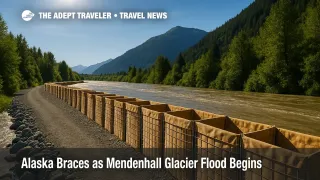
- HESCO barriers now line key riverbanks to protect hundreds of properties.
- City, tribal, state, and federal agencies are coordinating a unified response.
Snapshot
The City and Borough of Juneau reports that Suicide Basin is releasing water into Mendenhall Lake and the Mendenhall River, triggering evacuation advisories for mapped inundation zones. A state disaster declaration, issued August 10, positions resources and accelerates emergency permitting, communications, and protective actions. The National Weather Service hydrology team and the USGS are monitoring basin levels with cameras and a laser gauge to refine crest timing. Flood stages may build into August 13 as water routed from the glacial lake outburst flood moves through the system. Officials have erected miles of HESCO barriers to shield vulnerable neighborhoods, while door hangers, Wireless Emergency Alerts, and shelter operations support residents and visitors until waters recede.
Background
A glacial lake outburst flood, often abbreviated GLOF, occurs when water impounded behind ice, rock, or debris suddenly escapes and surges downstream. In Juneau, Suicide Basin, a side basin dammed by the Mendenhall Glacier, fills each spring and summer with rain and meltwater. When pressure overtops or undermines the ice dam, water drains rapidly toward Mendenhall Lake and the Mendenhall River. Juneau has grappled with these events for years, with 2023 and 2024 producing record flooding and widespread damage. This season, authorities installed temporary HESCO barriers along long stretches of riverbank and built a multi-agency response plan involving the city, Tlingit and Haida, the Alaska Division of Homeland Security and Emergency Management, the U.S. Army Corps of Engineers, the National Weather Service, and the USGS. The unified command aims to minimize impacts while longer-term mitigation is evaluated.
Latest Developments
Evacuations and defenses as Mendenhall Glacier flood risk rises
City officials say Suicide Basin is releasing, and flood impacts are expected late August 12 through August 13. Residents in the mapped 17-foot Mendenhall Lake inundation zone have been advised to evacuate until an all clear is issued, with shelter support at a local gymnasium and options for pet care through Juneau Animal Rescue. Messaging has gone out via Wireless Emergency Alerts, city SMS, and printed door hangers delivered to at-risk addresses. HESCO barriers now span more than two miles of riverbank to steer flows away from neighborhoods that saw heavy damage in 2023 and 2024. The governor's preemptive disaster declaration activates the State Emergency Operations Center, enabling emergency permitting, interagency coordination, and protective actions ahead of peak water levels. Visitors should heed closures near Mendenhall Glacier and avoid riverbanks where fast, debris-laden water and calving ice present serious hazards.
Timing, crest outlook, and monitoring you can trust
The National Weather Service and USGS report that overtopping began August 10, a classic signal that the basin is full and a release is underway. Based on prior events, a crest often follows within one to six days, with current guidance pointing to a peak along the Mendenhall River on August 13. Minor to moderate stages can arrive sooner as lake levels rise, then propagate downstream. Real-time monitoring, including USGS cameras and a laser range finder overlooking Suicide Basin, supports NWS hydrologic forecasts that drive warnings and evacuation advisories. Forecast refinements will account for rainfall, air temperature, and the evolving discharge path beneath or over the ice dam. Travelers should monitor official alerts, respect closures, and plan extra time if staying in the Mendenhall Valley. For broader planning in the region, see our destination guide Alaska.
Analysis, 220 to 300 words
Juneau's playbook reflects lessons from two consecutive record seasons. The preemptive disaster declaration removes friction for emergency permitting, sand stockpiles, and rapid contractor mobilization, while unified command meetings keep city, tribal, state, and federal teams aligned. HESCO barriers, which are modular wire-mesh cells filled with rock or soil, can be installed quickly to redirect overbank flow. Their performance depends on height, tie-ins at road crossings, and how long the river stays above design levels. Because the Mendenhall River conveys ice-rich, high-energy water during a glacial lake outburst flood, erosion at unarmored edges, end-runs around barriers, and undermining at seams remain risks. That is why officials continue to urge evacuations in mapped zones even as defenses stand ready.
Forecast uncertainty is inherent in GLOFs. Once overtopping begins, the exact discharge path through the ice dam can shift, altering timing and peak stage. Heavy rain in prior days can pre-prime channels and raise the baseline stage, raising compound-flood potential. The NWS-USGS instrument network shortens lead time and narrows the crest range, but last-mile outcomes still hinge on bank conditions and debris jams. For travelers, the practical takeaways are straightforward. Do not approach riverbanks, bridges, or closed trails near Mendenhall Glacier, verify tour operations before departure, and keep evacuation routes clear. If you are staying within the Mendenhall Valley, prepare a go-bag and follow official alerts until waters fall below flood stage.
Final Thoughts
This is a dynamic, locally driven emergency, and officials have moved early to protect people, homes, and essential services. The smartest travel choices mirror local guidance, which prioritizes evacuation, river avoidance, and patience with closures. If you have plans near Mendenhall Glacier, keep flexible itineraries, check with tour operators, and monitor city and NWS updates through August 13. Once levels recede and an all clear is issued, authorities will reassess access and recovery needs. Until then, stay situationally aware, give first responders room to work, and plan conservatively around the evolving Mendenhall Glacier flood.
Sources
- Governor Dunleavy Issues Disaster Declaration in Response to Imminent Glacial Flood Threat in Juneau, Alaska DHSEM
- Suicide Basin overtopping, flood watch active, City and Borough of Juneau
- Suicide Basin outburst underway, evacuate soon, City and Borough of Juneau
- Suicide Basin overview and updates, NWS Juneau
- USGS monitoring of the Juneau glacial outburst flood, USGS Alaska Science Center
- Juneau's glacial outburst flood has begun, Alaska Public Media
- Residents in Alaska's capital prepare for possible glacial flooding, AP News