Bermuda hurricane preparedness as Erin turns north
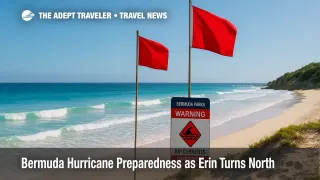
Bermuda officials are leaning into hurricane readiness as Erin tracks northwest, then north, keeping a healthy buffer while sending powerful swell across the island. After convening the Emergency Measures Organisation on August 18, the Acting Minister of National Security urged residents to complete preparations by Thursday morning and to avoid hazardous surf as red flag warnings become likely. The government said L.F. Wade International Airport, BDA, the Causeway, and public offices remain open, while transport agencies adjust select ferry services and monitor conditions.
Key Points
- Why it matters: Hazardous surf and rip currents will intensify despite a forecast miss.
- Travel impact: Airport and Causeway open, targeted ferry changes, cruise calls adjusted.
- What's next: Closest approach early Thursday with the track bending north away from Bermuda.
- BWS maintains a safe buffer of several hundred miles to the west.
- Utilities and agencies have activated hurricane plans and readiness messaging.
Snapshot
Erin's forecast cone now favors a northwest, then north turn, keeping the center several hundred miles west of Bermuda while driving long period swell and rip currents. At an August 18 briefing, officials warned against complacency, highlighted likely red flags on South Shore beaches, and asked residents to finish storm prep by late Thursday morning. The government said the airport and Causeway will stay open, with regular weekday buses and targeted ferry adjustments. The Bermuda Weather Service lists Erin as a potential threat within the wider region, but not a direct island strike, while the National Hurricane Center stresses dangerous surf for Bermuda, the U.S. East Coast, and Atlantic Canada.
Background
Bermuda's EMO framework coordinates ministries, the BWS, first responders, transport, and utilities for tropical systems that pass near the island each season. On August 15, the government noted Erin's upgrade to hurricane status and set the stage for ongoing EMO coordination. As of August 18, authorities reiterated that Erin is not expected to make landfall in Bermuda, however its large wind field will send dangerous seas toward South Shore beaches and exposed coasts. BELCO reported operational readiness and continued alignment with government guidance. The Royal Gazette's morning weather update cited BWS guidance placing the closest approach in the low to mid 300 nautical mile range to the west around early Thursday, reaffirming a safety margin while surf and winds build. NHC advisories echo the swell and rip current risks for Bermuda through midweek.
Latest Developments
EMO urges readiness, with airport and Causeway open
At the August 18 press conference, the Acting Minister said Erin is not a direct strike, but will come close enough to deliver tropical storm force gusts offshore, increasingly hazardous surf, and red flag conditions on popular beaches. Residents were told to complete preparations by late Thursday morning. Government confirmed the airport, the Causeway, and public offices remain open. Bus service runs on a normal weekday schedule, while ferries suspend the Orange Route from Tuesday, with Blue, Pink, and Green Routes continuing as normal. Officials added that the EMO will reconvene on Wednesday, August 20, or sooner if the track changes. The BWS and NHC continue to message life threatening surf and rip current risks even as the track bends north.
Forecast track bends north, keeping a buffer west of the island
Morning BWS guidance and local reporting place Erin's closest approach around early Thursday, roughly 320 to 340 nautical miles to the west to west northwest, preserving a safe buffer while seas remain rough. NHC advisories expect a northwest, then north turn from late Monday through Tuesday, with the storm remaining large and dangerous over open water. The takeaway for travelers is classic Bermuda hurricane posture, limited operational changes on land, and significant near shore hazards. Expect red flags at exposed beaches, stronger rip currents, and occasional ferry adjustments if winds freshen.
Analysis
Bermuda's messaging strikes the right balance for a close pass without direct impact. The EMO is signaling continuity of core services, minimizing avoidable disruption, while sharpening beach and marine warnings as swells build. That aligns with NHC guidance when large hurricanes pass well offshore, where the principal hazards are in the surf zone, small craft conditions, and periods of squally showers. The clear instruction to finish preparations by Thursday morning front loads any supply runs or yard work, then keeps people off the roads if seas and winds pick up. It also counters a familiar complacency risk whenever models trend away from a direct hit.
For travel, the practical watch items are beach closures or red flags, sporadic ferry tweaks, and airline schedule housekeeping. The airport operator continues normal operations at L.F. Wade International Airport, BDA, and the Causeway remains open, which preserves inbound and outbound connectivity. Cruise lines are already adjusting calls, a common step when cross wind and swell alignment complicate berthing at Royal Naval Dockyard. Those shifts began days ago and will continue to evolve with the marine forecast. For context on cruise changes, see our coverage in Tropical Storm Erin Cruise Updates: Reroutes Begin and Vision of the Seas Rerouted as Erin Stirs Atlantic Swell. Expect steady government updates if the track wobbles, but the north bend keeps the island in a generally favorable quadrant for reduced wind risk compared with a direct approach.
Final Thoughts
Bermuda is treating Erin as a real world drill, keeping planes and government services moving while telling people to lock in supplies and stay out of dangerous surf. With the track bending north and a closest approach several hundred miles to the west, the island's risk profile centers on beaches and small craft, not widespread closures. If you are flying via L.F. Wade International Airport, BDA, or transiting by ferry, watch for targeted changes. The core message is simple and sensible, a hallmark of effective Bermuda hurricane preparedness.
Sources
- Video: Govt Press Conference On Hurricane, Bernews
- 6am update: Erin at Cat 4 strength as potential threat to Bermuda, Royal Gazette
- Hurricane Erin Public Advisory Number 30, National Hurricane Center
- Hurricane Erin Forecast Discussion, National Hurricane Center
- Hurricane Erin Update: Current Status, Government of Bermuda
- Hurricane Erin Updates, BELCO