Outer Banks closures, rip-current rescues as Erin exits
Hurricane Erin is turning east and moving away from the U.S. coastline, but the Outer Banks are still dealing with dangerous surf, coastal flooding, and closures on August 21, 2025. Double red flags remain up countywide, and stretches of NC 12 on Hatteras Island are closed due to overwash. National Park Service sites delayed openings or remain shut while damage and debris are assessed. Elsewhere along the North Carolina coast, lifeguards reported dozens of rip-current rescues earlier in the week as long-period swells built in.
Key Points
- Why it matters: Road and beach closures are stranding communities and disrupting late-summer travel plans.
- Travel impact: NC 12 closures cut access on Hatteras Island, and ocean swimming is prohibited across Dare County.
- What's next: Conditions gradually improve through August 22 to 23, but dangerous rip currents linger into the weekend.
- Parks and piers are inspecting damage, with phased reopenings once debris and erosion hazards are cleared.
- Ferry and county services adjust as highway conditions and tides allow.
Snapshot
Tropical-storm conditions eased as Erin tracked offshore, yet long-period swell kept surf hazardous from Cape Lookout to Duck. Dare County kept double red flags posted, making ocean entry illegal across all public beaches. The National Park Service delayed openings at Fort Raleigh National Historic Site and Wright Brothers National Memorial until noon on August 21, and it closed other Cape Hatteras National Seashore facilities until further notice while staff assessed ocean overwash, dune damage, and debris. NC 12 was closed from Oregon Inlet to Hatteras Village at points beginning the evening of August 20, with flooding and sand covering travel lanes. Earlier in the week, southeastern North Carolina lifeguards reported more than 70 rescues at Wrightsville Beach alone as Erin's swells built.
Background
Barrier islands like the Outer Banks are highly vulnerable to storm surge, soundside flooding, and dune erosion, even when a hurricane remains offshore. Mandatory evacuations were issued earlier this week for Hatteras and Ocracoke Islands as forecasts called for 2 to 4 feet of inundation in low-lying areas, 15 to 20-foot surf, and prolonged overwash around high tides. Countywide, double red flags prohibit ocean entry, with violations punishable as a Class 2 misdemeanor. The National Weather Service warned that rip currents would remain life-threatening through late week. Beyond the Banks, cruise ships adjusted routes to avoid the worst seas, including the itinerary covered in our update, Hurricane Erin cruise diversions: Norwegian Escape.
Latest Developments
Outer Banks closures continue as Erin moves offshore
Erin's closest pass to North Carolina occurred early August 21, and the storm has begun shifting east, yet the impacts are lingering. Dare County relayed an NCDOT notice closing NC 12 from Oregon Inlet to Hatteras Village on the evening of August 20, with closures and blockages persisting into August 21 as tides and surf kept pushing sand and water across the road. The National Weather Service's 6 a.m. briefing called this a long-duration event for the Outer Banks, with Highway 12 likely impassable at times through late week, and surf up to 15 to 20 feet driving severe beach erosion. The county's transportation services south of the Basnight Bridge remain suspended until conditions allow, and trash collection schedules on Hatteras Island are delayed.
Parks, beach access, and town advisories
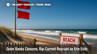
The National Park Service delayed opening Fort Raleigh and Wright Brothers Memorial until noon on August 21, closed Bodie Island Lighthouse for August 21, and kept all other Cape Hatteras National Seashore facilities closed until further notice. The Seashore also reported ocean overwash at known Highway 12 hotspots and temporarily closed beachfront in Rodanthe and Buxton due to threatened structures. Towns from Duck to Nags Head kept double red flags up, removed some lifeguard stands, and shifted to roving patrols where necessary. Officials emphasize that flag removals during high winds do not signal a reopening; the ocean remains closed to swimmers until agencies lift double red conditions.
Rip-current rescues across North Carolina beaches
While beaches on the Outer Banks have been closed to ocean entry, rip currents from Erin drove rescues elsewhere along the coast earlier in the week. Wrightsville Beach lifeguards reported between 60 and 70 rescues on August 18, with additional rescues on August 19 prompting a no-swim advisory through August 22. Regional media tallied nearly 85 rescues across southeastern North Carolina as swells built, underscoring the danger from distant hurricanes. The National Weather Service continues to warn that even as the storm pulls away, long-period swell will keep rip-current risk elevated into the weekend.
Analysis
For travelers, the headline is persistence. Erin is moving away, but the ocean energy it generated will linger for days. That means red-flag closures and sporadic NC 12 blockages can continue through multiple high-tide cycles, complicating check-ins, grocery runs, and service calls on Hatteras and Ocracoke. If you have an arrival or departure in the next 48 to 72 hours, plan flexible timing, expect detours, and keep vehicles on higher ground. Lodging hosts should proactively message guests with clear parking and access instructions, plus alternate directions if NC 12 reopens in phases. Parks and towns will reopen facilities as soon as debris, dune scarping, and threatened structures are cleared, but do not assume morning improvements will hold into the evening tide. Finally, treat rip currents as a travel hazard equal to wind or rain. Double red flags make the ocean legally off-limits in Dare County. When flags drop to single red or yellow later this week, use guarded beaches only, and talk to lifeguards before entering the water.
Final Thoughts
The Outer Banks will start to look calmer as Erin exits, but powerful swell will keep risk high. Expect staggered reopenings for Park Service sites, cautious service resumptions on Hatteras Island, and red-flag rules to ease only when surf and tides cooperate. If you are inbound, stay flexible, monitor town and NPS alerts, and build extra time into any drive along NC 12. When in doubt, ask a lifeguard and stay on shore. The priority is a safe, unhurried return from these Outer Banks closures.
Sources
- Hurricane Erin Briefing #13, National Weather Service Newport/Morehead City
- Hurricane Erin stirs up strong winds and floods part of a NC highway, Associated Press
- Hurricane Erin threatens North Carolina's Outer Banks with storm surge, Reuters
- Hurricane Erin live updates, ABC News
- Dare County Hurricane Erin hub, including NCDOT NC 12 closure update, Dare County
- Cape Hatteras National Seashore closures and delayed openings, National Park Service
- Portions of Highway 12 stay closed as Erin makes mess on roads, WITN
- Wrightsville Beach rescues and no-swim advisory, WECT
- Rip-current rescues totals follow-up, WRAL