Tropical Storm Lorenzo: track, travel impacts, insurance
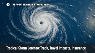
Tropical Storm Lorenzo formed over the central tropical Atlantic on October 13, 2025, with maximum sustained winds near 45 mph and a northwest motion of about 17 mph. Forecast guidance from the National Hurricane Center indicates a gradual turn to the north on Tuesday, keeping the system over open water for the next several days with no coastal watches or warnings in effect. While Lorenzo is not a land threat based on current projections, travelers may still see indirect effects on ocean conditions and long-haul routings.
Key points
- Why it matters: Lorenzo adds swell and shipping considerations across the mid-Atlantic, though no land impacts are expected.
- Travel impact: Ocean swells could alter cruise pacing and tender calls in open-ocean waters, but widespread airline impacts are unlikely.
- What's next: A northward turn keeps Lorenzo at sea through midweek as forecasters monitor for gradual strengthening.
- Insurance note: Named storms narrow insurance options if you buy after the name is assigned.
- Resource: See our explainer on the named-storm clause in travel insurance, How the Named-Storm Clause Resets Your Travel Insurance.
Snapshot
As of the early Monday advisory on October 13, Lorenzo was located over the central tropical Atlantic, roughly 1,000 miles west of the Cabo Verde Islands, carrying 45 mph sustained winds. Forecasters expect the storm to slow slightly, then arc north over open waters on Tuesday, with gradual strengthening possible by midweek. No coastal watches or warnings have been issued, and reliable model consensus keeps Lorenzo away from the Caribbean, the U.S. East Coast, and Europe through the five-day period. Travelers should expect the main near-term effect to be increased swells across parts of the central Atlantic shipping lanes, which can translate to choppier seas on repositioning voyages or extended tender operations, rather than airport or port closures.
Background
Lorenzo is the twelfth named system of the 2025 Atlantic season, forming near the climatological pace for an "L" storm. The National Hurricane Center's cone and discussion emphasize an open-ocean track, with tropical-storm-force winds extending outward from the center and the wind radii over water. When storms remain far from land, the most visible travel effects typically involve maritime operations, such as route adjustments to avoid rougher seas or arrival windows shifted to match calmer conditions. Airlines occasionally add fuel or minor time buffers on trans-Atlantic routes to work around convective clusters, but widespread schedule changes are unlikely without a closer or stronger approach. As always, travelers should monitor carrier alerts and cruise-line apps for any tactical tweaks.
Latest developments
Tropical Storm Lorenzo track: open-ocean curve, low direct risk
The latest National Hurricane Center products call for Lorenzo to continue northwest today, slow down slightly, then turn north on Tuesday and northeast later in the week, remaining well away from land. Forecasters note the potential for gradual strengthening over sufficiently warm waters and a generally favorable environment, though Lorenzo's track over the open Atlantic limits coastal risk. With the wind field confined to the marine domain and no watches or warnings posted, major flight disruptions are not anticipated. Cruise operators crossing mid-Atlantic waters may adjust speeds or spacing to ride more comfortable seas, a routine measure when swells increase along common shipping lanes. Travelers should still enable push alerts, but broad rebooking waivers are unlikely for this system given today's guidance.
Analysis
With Lorenzo forecast to stay at sea, the risk profile for most travelers remains low. The primary exposure is maritime, where persistent swells can lengthen tender times, affect entertainment schedules, or prompt small tweaks to sea-day routing. Cruise lines routinely optimize tracks to minimize motion, so expect behind-the-scenes adjustments rather than headline itinerary changes. For aviation, the trans-Atlantic corridor is flexible, and flight planning can detour around convective clusters with modest fuel and time penalties that passengers rarely notice. The most important planning lever for travelers is insurance timing. Once a storm is named, it becomes a known event, and new policies will generally exclude that storm's impacts. If your fall itinerary includes hurricane-season regions, securing coverage at the time of booking preserves storm-related benefits, and "Cancel For Any Reason" can add flexibility where standard policies cannot. For a recent case study on storm-driven adjustments and traveler options, see our hurricane coverage archive entry, Hurricane Erin Travel Update: Flights, Cruises, Outer Banks.
Final thoughts
Tropical Storm Lorenzo is an open-ocean system with a northward turn that keeps it far from land through the five-day window. Expect minimal airline effects and only routine cruise adjustments to manage swells along shipping lanes. Your best move is to keep alerts on, check the National Hurricane Center cone once daily, and confirm your insurance timing if you have fall travel across hurricane-season regions. If the forecast changes, we will update with any airline waivers or cruise itinerary notices, but today's guidance keeps direct risk low from Tropical Storm Lorenzo.
Sources
- Tropical Storm Lorenzo, NHC public advisory and graphics, NOAA
- Tropical Storm LORENZO advisory archive, NOAA
- NHC homepage, active advisories excerpt, NOAA
- Tropical Storm Lorenzo forms in the Atlantic, AP
- Lorenzo overview and context, Weather.com
- Hurricane and weather coverage rules, Squaremouth
- Named storm becomes a known event, Squaremouth FAQ
- Hurricane travel coverage timing, InsureMyTrip FAQ
- Known peril and weather delays, InsureMyTrip