Canada Weather Ripple, Significant Delays at Toronto, Moderate at Montreal
Weather and U.S. air traffic flow controls are rippling into Canada this morning, pushing Toronto Pearson International Airport (YYZ) into a significant delay status and keeping Montréal Pierre Elliott Trudeau International Airport (YUL) at moderate. The FAA's National Airspace System page shows a formal Ground Delay Program at Newark, a key U.S. gateway for Canada transborder connections, which is adding metering and knock on holds upstream. Air Canada's Daily Travel Outlook highlights airports at risk for schedule adjustments today, and WestJet has an active winter weather advisory for multiple Ontario and Quebec stations through November 10. Travelers should pad connections, especially on U.S. bound routes transiting New York or Chicago, and reconfirm same day rail or coach transfers.
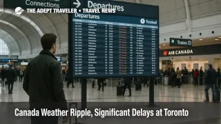
Toronto Pearson, significant delays
Operational snapshots point to a meaningful slowdown at Toronto Pearson, with live airport condition monitors labeling the delay status as significant as of Monday morning. Reported conditions include overcast skies, three miles of visibility, and a north northwest wind, a setup that tends to reduce arrival acceptance rates and lengthen departure queues when paired with downstream metering in the United States. Expect heavier pressure on transborder banks and late morning domestic connectors as rotations absorb early holds.
Montreal Trudeau, moderate delays
Montreal is faring better, holding at a moderate delay status in the morning push. Overcast conditions and reduced visibility are present, but flow remains steadier than Toronto and should allow many itineraries to operate near scheduled, with the caveat that any widening of U.S. programs at New York area airports could cascade into afternoon spacing.
Why U.S. programs matter to Canada today
When the FAA institutes a Ground Delay or similar initiative at a major U.S. hub, international and transborder arrivals bound for that hub receive controlled departure times to avoid congestion. That metering reverberates through upstream airports such as Toronto and Montreal, stretching turn times and consuming slack in crew schedules. Newark is under a Ground Delay Program this morning, and continued staffing driven initiatives in the U.S. have kept several busy facilities on restrictions since late last week. The bottom line for travelers is simple, Canada U.S. routes will feel tighter than the local weather alone suggests.
Airline outlooks and waivers
Air Canada's Daily Travel Outlook page lists airports where weather or operational factors may cause delays or cancellations, and it is the first stop for customers deciding whether to move flights within the same travel window. WestJet has published a winter storm advisory covering Toronto, Montreal, and several secondary Ontario and Quebec airports for travel through November 10, which can unlock change fee flexibility where inventory permits. Monitor both pages for midday updates as conditions evolve.
What to do now
If you are connecting in Toronto or Montreal on a U.S. bound itinerary, add 90 to 120 minutes of buffer, especially if your path touches the New York area. Use your airline app to accept earlier seats when they appear, since programs can compress late banks and leave fewer options later in the day. If your plans include VIA Rail or regional coach transfers, reconfirm your ground timeline after your flight's controlled departure time posts on the airline or airport page. Keep an eye on the FAA NAS Status page for changes at Newark, LaGuardia, or JFK, and refresh Air Canada's Daily Travel Outlook before you head to the airport.
Final thoughts
Canada's primary hubs are operating, but the combination of local weather and U.S. flow controls is the driver today. Toronto is significant, Montreal is moderate, and transborder banks are where the pressure concentrates. Build buffers, keep flexible options in mind, and watch the official pages noted above for the quickest read on changes.