Brazil Storm Alerts Hit São Paulo Corridor
A strong storm system tied to a fast moving cold front is now an operational factor for anyone using the São Paulo Campinas air corridor. Brazil's national meteorological agency, Inmet, has placed the south and southeast of São Paulo state, all of Mato Grosso do Sul, and Rio Grande do Sul under orange level storm alerts through at least the morning of November 17, with forecast rainfall of 30 to 60 millimeters and local totals near 100 millimeters, plus winds of 60 to 100 kilometers per hour. That combination raises the risk of power cuts, fallen trees, and flash flooding, and it puts late day arrivals at São Paulo and Campinas airports at higher risk for ground holds, diversions, and rolling delays.
Storm Coverage For São Paulo, Campinas, And Southern States
Inmet's newest bulletins frame the episode as a multi state severe weather phase driven by a sharp cold front and an embedded low pressure system that will sweep from the south toward the southeast and center west regions. For travelers, the most relevant detail is geographic. The orange level polygons now cover the southern and southeastern parts of São Paulo state, all of Mato Grosso do Sul, and Rio Grande do Sul, while neighboring belts sit under yellow level "potential danger" alerts.
Within that broader picture, Campinas and its metropolitan area are under a specific orange level "danger" alert from 300 a.m. BRT on November 17, 2025, through 300 a.m. BRT on November 18, 2025. Local guidance warns of intense rain, gusts that may reach 100 kilometers per hour, and the possibility of hail, along with a tangible risk of power outages, crop damage, falling trees, and urban flooding. This is the exact window that overlaps with many early morning departures and the evening arrival banks at Viracopos International Airport (VCP), which functions as a hub for Azul and an important cargo gateway for São Paulo state.
The same cold front and embedded disturbances are also driving red level "great danger" alerts farther south in parts of Mato Grosso do Sul, Paraná, Santa Catarina, and Rio Grande do Sul, where Inmet warns of rainfall above 60 millimeters per hour or more than 100 millimeters per day, with even stronger wind gusts. Travelers connecting through Porto Alegre or other southern hubs need to treat that as a higher tier risk, while those focused on São Paulo and Campinas sit in the orange middle band where dangerous conditions are possible but usually localized.
Latest Developments
The immediate change for the São Paulo corridor is that parts of the area have stepped up from yellow to orange alerts as models converged on heavier convective bands. Inmet's three tier scale runs from yellow for "potential danger," to orange for "danger," and then red for "great danger," with each escalation signaling greater likelihood of damage from wind, rain, or flooding. Municipal civil defense agencies in São Paulo state are already warning about localized flooding in low spots, urging residents to avoid walking or driving through standing water and to report blocked drainage.
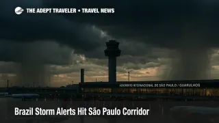
Aviation specific impacts will depend on how storm cells line up with peak traffic periods at São Paulo Guarulhos International Airport (GRU), São Paulo Congonhas Airport (CGH), and Viracopos International Airport (VCP). Past episodes of intense rain and crosswinds in the capital have produced clusters of cancellations and diversions, particularly at Congonhas, which sits in a dense urban setting with shorter runways and tighter operational margins. Even without a headline making shutdown, the combination of low ceilings, lightning near the field, and ramp safety protocols tends to trigger short ground stops and slower departure rates that ripple into missed connections later in the day.
So far, this is a weather story rather than a security shift. The United States State Department continues to rate Brazil at Level 2, exercise increased caution, for crime and kidnapping, and has not issued a separate advisory related to the current storms. Travelers still need to apply normal urban safety practices in São Paulo and Campinas, but the decision point for this week is timing and routing around the severe weather window, not a change in baseline security conditions.
Analysis
The São Paulo Campinas air corridor is one of Brazil's busiest travel axes, fed by both domestic shuttle traffic at Congonhas and long haul international flights at Guarulhos, with Viracopos acting as a hybrid passenger and cargo hub that pulls in regional feeders. On the ground, that same corridor rides along the Rodovia Anhanguera and Rodovia dos Bandeirantes highways, which are among the country's most heavily used and economically important routes linking São Paulo to Campinas and beyond. When a storm system puts that whole spine under heavy rain and wind, both air and surface options become more fragile at the same time.
In practical terms, travelers flying into GRU or CGH with onward domestic connections, or those connecting from domestic feeders at Viracopos onto long haul flights, should treat arrivals from late afternoon into the night of November 17 as higher risk. Convective storms in this region often peak in the late day and early evening, which is exactly when ramp closures for lightning and wind can create short but sharp waves of delay. Add a multi airport storm footprint and the odds of knock on disruption rise, even if each individual airport remains technically open.
Background: How Inmet Alerts Work For Travelers
Inmet's color scale is not just a meteorological detail. Yellow alerts flag the potential for intense rain or wind, but with lower probability of widespread damage. Orange alerts indicate "danger" for people and infrastructure, with a higher expectation of power cuts, falling trees, crop damage, and urban flooding. Red alerts, which are currently focused farther south, mark "great danger," where the agency expects major impacts, hail, and very strong winds.
For a traveler, the shift from yellow to orange on the São Paulo Campinas corridor means that secondary risks begin to matter as much as airport status. A fallen tree on an access ramp, a flooded underpass near a bus terminal, or a localized power cut at a hotel can derail an otherwise normal itinerary. That is why the current Brazil storm alerts should be read as a cue to build redundancy into airport transfers and overnight plans, not only as a warning about turbulence or bumpy landings.
Buffers, Routing Choices, And Backup Plans
Anyone arriving into GRU, CGH, or VCP during the alert period should consider adding at least two to three hours of buffer before any separate ticket connection, especially where a long haul flight depends on a domestic feeder. When possible, move critical appointments, such as cruise embarkations, safari departures, or nonrefundable tours, to at least a day after arrival. The history of weather related cancellations at Congonhas and storm driven delays at Viracopos shows how quickly localized conditions can force abrupt schedule changes.
If flying between São Paulo and Campinas, evaluate whether an intercity bus might be a more predictable option in this window, especially for same day connections that would otherwise rely on a short hop flight. Direct buses run frequently between São Paulo's Tietê Bus Terminal and Campinas, with typical travel times around ninety minutes in normal conditions, and they use the Anhanguera and Bandeirantes highways that form the main surface corridor between the two cities. Heavy rain can still slow these routes, but buses are less sensitive than planes to temporary closures or lightning, and they give travelers more control over departure times.
On the hotel side, it makes sense to favor properties with reliable backup power, good drainage, and straightforward access to main roads. Near GRU this often means airport area hotels with shuttle service that avoid low lying neighborhoods. In central São Paulo and Campinas, look for hotels with multiple access routes, including proximity to metro or commuter rail where practical, in case part of the road network floods.
Final Thoughts
Brazil storm alerts are now an active planning variable for anyone using the São Paulo Campinas corridor through at least early November 18. Orange level Inmet warnings for parts of São Paulo state, combined with broader severe weather risk in Mato Grosso do Sul and Rio Grande do Sul, tilt the odds toward at least minor disruption even if the airports formally remain open. With the national US advisory for Brazil still set at Level 2, exercise increased caution, the main lever for travelers is operational rather than security related, which means building larger buffers, choosing resilient hotel locations, and having backup surface routes ready for the São Paulo Guarulhos, Congonhas, and Viracopos triangle.
Sources
- Inmet alerta para tempestades em três estados até amanhã
- INMET emite alerta laranja de tempestade com ventos de até 100 km/h em Campinas e região até terça-feira
- Clima, semana começa com alerta laranja para várias regiões
- Alerta, risco de tempo severo nas Regiões Sul, Centro-Oeste e Sudeste
- Rodovia Anhanguera SP 330, História, Mapa, Câmeras
- Rodovia dos Bandeirantes SP 348
- São Paulo to Campinas, 4 ways to travel via bus, car, and taxi
- Brazil Travel Advisory, Level 2 Exercise Increased Caution