Death Valley Flooding Closes Iconic Park Roads
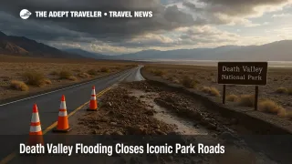
A rare mid November storm has again turned Death Valley National Park into a flood zone, closing some of its most famous sightseeing roads just as cooler season road trips are ramping up. A National Park Service news release and regional outlets confirm that a storm on November 15, 2025, dropped about 0.6 inches of rain at Furnace Creek, more than a quarter of the park's average annual rainfall, and sent fast moving water, mud, and debris across pavement in multiple corridors. As of November 17, key scenic routes such as Badwater Road, North Highway, West Side Road, Twenty Mule Team Canyon, and the road to the Charcoal Kilns are all closed, even while the main highway spine across the park remains open.
For travelers, the immediate change is that the classic drive along the valley floor is off the table, and itineraries built around easy car access to Badwater Basin, Artists Drive, and backcountry viewpoints off North Highway need reworking. The good news is that California 190 still carries traffic across the park, California 178 Trona Wildrose Road, Daylight Pass, and the paved access road to Dantes View remain open, so it is still possible to cross Death Valley and reach most in park lodges and campgrounds with careful planning.
Death Valley Road Closures After November Storm
The current wave of closures builds on a rough year for Death Valley's road network. The November 15 storm came on top of late summer floods that had already damaged several corridors, and park officials note that North Highway and Badwater Road had only just reopened for two days after earlier repairs before this latest event forced them shut again.
According to the park's road status page and the official news release, the paved roads that are currently closed include the full length of Badwater Road, which normally carries drivers to Badwater Basin and many of the valley floor salt flats, Artists Drive, which is off limits even to cyclists and pedestrians because of debris and damage, North Highway, which links Furnace Creek to Ubehebe Crater and the park's northwestern interior, and the scenic spur roads for West Side Road, Twenty Mule Team Canyon, and the Charcoal Kilns area.
Unpaved roads and backcountry tracks have fared no better. The National Park Service notes that West Side Road remains closed with no estimated reopening date after compound flood damage from September and November storms, that Upper Wildrose Road, which serves the Charcoal Kilns and primitive campgrounds at Thorndike and Mahogany Flat, is closed after the latest washouts, and that other popular four wheel drive routes such as Cottonwood and Marble Canyon are in rough condition with water still running across the final miles. Park staff explicitly warn that many unpaved roads may be impassable because of mud flows or erosion and that visitors who try to push deeper into the backcountry should be prepared to self rescue.
At the same time, the through highways that most road trippers rely on remain open. California 190 is still carrying traffic across the entire park, giving access to Furnace Creek, Stovepipe Wells, Mesquite Flat Sand Dunes, and Panamint Springs, while California 178 Trona Wildrose Road from the west, Daylight Pass from the east near Beatty, and the paved road to Dantes View are all open at last report. These roads can close quickly if new slides develop, so the status may change again on short notice.
Latest Developments
The November storm is part of a broader atmospheric river pattern hitting California, especially the desert interior. Meteorologists with the National Weather Service told SFGate that the same moisture plume shattered daily rainfall records in multiple Southern California cities and delivered more than half an inch of rain to Death Valley itself in a single day, enough to cause destructive flooding in a landscape that usually sees only a few inches in a full year. Local reports describe steep desert slopes funnelling water into narrow canyons and across paved road cuts, scouring shoulders and leaving flows of rock and mud that are unsafe to drive or walk on until crews can clear and inspect them.
As of the latest update on November 17, 2025, the National Park Service road status page confirms the same set of closures listed in the news release and notes that conditions are still being assessed, with the possibility of additional shutdowns if further damage is found. The park's conditions page also flags several facilities issues, including closed restrooms at Dantes View and Emigrant, which may affect day trip logistics even where roads themselves are open.
Campgrounds and in park accommodation remain open, which is critical for visitors who already hold reservations. Furnace Creek, Stovepipe Wells, Mesquite Spring, and Wildrose campgrounds are listed as open, along with primitive sites at Eureka Dunes, Saline Valley, and Homestake, while Sunset, Texas Springs, Emigrant, Thorndike, and Mahogany Flat campgrounds are closed. Lodging properties at Furnace Creek, Stovepipe Wells, and Panamint Springs are also open year round and reachable via the park's open paved highways, although guests approaching from the west should watch for any new advisories from Caltrans and Inyo County road departments.
Analysis
For visitors, the practical problem is not that Death Valley is closed, but that the usual mix of easy valley floor drives and short scenic spurs is temporarily off the menu. If your bucket list visit is centered on driving down Badwater Road, stopping at Badwater Basin, and then looping Artists Drive, the current closures mean you have to design a different experience around the roads that are still usable.
In the short term, travelers can pivot to a rim focus. California 190 still delivers access to Zabriskie Point, the Furnace Creek Visitor Center, Mesquite Flat Sand Dunes near Stovepipe Wells, and Panamint Springs, while the access road to Dantes View remains open and often provides one of the most dramatic overlooks in the park. These sites offer classic landscapes and photography without requiring any off road driving, and they work well as day trips from in park lodges or from gateway towns such as Beatty, Pahrump, or Shoshone.
Backcountry driving is a different story. With Upper Wildrose and West Side Road heavily damaged and many unpaved segments described as rough or impassable, visitors should assume that unsigned dirt tracks and social roads are effectively closed unless the National Park Service specifically lists them as open. Even if you travel in a high clearance vehicle with four wheel drive, the combination of deep mud, undercut shoulders, and missing road segments can turn a simple detour into a recovery operation in a very remote environment. Park rangers also emphasize that driving off the legal road corridor to bypass washouts creates lasting damage in designated wilderness areas.
For guided tours and shuttle based day trips, the likely adjustment is a shift from valley floor loops to scenic overlooks on the park's eastern and western edges. Operators can still deliver strong experiences built around sunrise at Zabriskie Point, daytime dune walks near Stovepipe Wells, and sunset at Dantes View, as well as night sky programs that take advantage of cooler temperatures and clear air once the storm has passed. Travelers should watch for updated tour descriptions and be prepared for last minute route changes as operators respond to evolving road conditions.
Background
Death Valley's road network has always been vulnerable to sudden flood damage because of the desert's extreme topography and climate. The park receives very little rain in a typical year, but when a moisture rich system like an atmospheric river moves across its steep, rocky basins, water cannot soak in. Instead, it races downslope in concentrated flows, scouring gullies, carrying boulders, and depositing debris in low spots where roads often sit. Over the past several years, a series of intense storms has repeatedly washed out paved and unpaved routes, forcing the National Park Service to triage repairs and leaving some backcountry roads closed for whole seasons.
This latest round of Death Valley flooding fits the broader pattern emerging across California, where warmer oceans and atmosphere can load more moisture into storms. The result is a higher likelihood of short, intense rainfall events that overwhelm drainage, especially in desert basins, canyon road cuts, and older infrastructure. For travelers, that means the shoulder seasons that once offered reliably dry driving conditions now come with a modest but real risk that key scenic roads may be closed right when temperatures are most comfortable.
How To Check Routes And Build Backup Plans
Before driving into Death Valley, visitors should take a few concrete steps. First, check the National Park Service conditions page for Death Valley and scroll to the Road Status section, which lists closed paved roads, closed backcountry roads, and any cautions such as deep sand or rough sections. Second, follow the links from that page to California highway information and Nevada road conditions to confirm that approach routes like California 190, California 178, and the main highways from Las Vegas or the Owens Valley are still open.
Third, reframe your itinerary around a mix of open highlights rather than expecting to improvise via side roads on the day. If Badwater Road and West Side Road are closed, consider centering a one or two day visit on Zabriskie Point, Furnace Creek, Mesquite Flat Sand Dunes, and Dantes View, all of which currently remain accessible from the open highway network. Finally, treat unpaved or unsigned tracks that do not appear on the current NPS map as off limits for vehicles, even if your navigation app suggests them, and carry enough water, food, and fuel to handle an unplanned delay or a long detour.
If you already hold lodging or campground reservations inside the park, reach out to your hotel or to the park's information line to confirm access routes on the day before arrival and again on the morning of your drive. Advisors planning trips for clients should flag that certain iconic spots are temporarily inaccessible by car and position alternative experiences that still deliver strong views, starry skies, and the distinctive sense of scale that make Death Valley compelling even when floods have rearranged the roads.
Final thoughts
Death Valley is still open, but Death Valley flooding has reshaped how visitors can experience it in the near term. With Badwater Road, North Highway, and several other scenic corridors closed, the valley floor road trip experience is on hold, and travelers need to lean on the open highway spine, rim overlooks, and in park lodges that remain accessible. By checking conditions carefully, treating unsigned dirt tracks as closed, and building flexible backup plans, visitors can still put together a meaningful Death Valley visit while leaving space for road crews to rebuild the damaged routes.