Costa Rica Route 32 Closure Cuts Access To Caribbean Coast
Travelers heading from San José to Costa Rica's Caribbean coast now face longer, less predictable transfers because Route 32, the main highway through Braulio Carrillo National Park to Limón and Tortuguero connections, has just come off a long weather closure and remains vulnerable to sudden shutdowns. Heavy rains triggered landslides and exposed a huge unstable boulder above the roadway near kilometer 31 in early November, forcing the Ministry of Public Works and Transport, MOPT, to close the San José to Guápiles mountain section for days at a time while engineers blasted rock and cleared debris. Even though traffic has begun to flow again in recent days, officials are still using preventive closures and tight monitoring, so travelers should plan around detours and delays rather than assuming a normal three and a half hour run to the coast.
The core shift for travelers is that Route 32 can no longer be treated as a guaranteed fast corridor between the Central Valley and Limón. For at least the rest of November, anyone routing to Limón, Puerto Viejo, Cahuita, or Tortuguero should build in extra time, know the main detour options, and keep a backup plan in case MOPT reinstates a full closure around the Zurquí sector with little notice.
Route 32's problem zone and what is actually closed
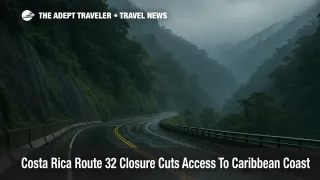
Route 32 is Costa Rica's main Caribbean highway, running from San José through Braulio Carrillo National Park to Guápiles and on to Limón. The current problems are concentrated around kilometers 28 to 31 in the Zurquí mountain sector, where repeated landslides, soil saturation, and falling trees have kept engineers busy since at least 2022.
On November 3, 2025, MOPT ordered a full closure of the San José to Guápiles stretch after intense rain brought down fresh material near Zurquí. Within days, geologists identified a boulder of roughly 50 cubic meters, about 7 meters high and 6 meters wide, weighing an estimated 2,500 tons, perched above the highway at kilometer 31. Authorities extended the shutdown and planned a controlled explosion to break the rock apart before it could fall uncontrolled onto the road.
By November 10, local media and MOPT confirmed that the highway remained shut with no firm reopening date, and a separate report cited over ₡ 4,000 million in economic losses from the interruption. Digital outlets that track the highway described the closure as "indefinite" while the rock and slide risk remained active and weather stayed unstable.
After crews dynamited the boulder and removed repeated fresh landslide material, MOPT reopened Route 32 on November 15, about 12 days after the original shutdown, but stressed that the road would stay under heavy monitoring. In practice, that has meant that travelers can drive the usual San José to Guápiles corridor again, but must still expect preventive closures, especially at night or during intense rain, and occasional daytime inspections that briefly halt traffic.
For planning purposes, that makes Route 32 a "use it if it is open today, but do not bet your only connection on it" corridor for the next several weeks, particularly if you have nonrefundable Caribbean hotel nights or pre-booked Tortuguero boat transfers riding on a specific arrival window.
How detours via Turrialba and Vara Blanca actually work
Background: When Route 32 closes, Costa Rican officials usually fall back on a set of alternative roads that connect the Central Valley to the Caribbean lowlands around Siquirres and Limón. These are real public highways, but they were not designed to absorb all of Route 32's heavy truck and tourism traffic, so they can feel slower, narrower, and more chaotic in bad weather.
MOPT and local media now routinely highlight three main alternatives when Route 32 is restricted:
- Via Cartago and Turrialba on Route 10, then down through Siquirres to Limón.
- Via Vara Blanca and the Sarapiquí corridor, using Route 126 and then Route 4 toward the Caribbean plains.
- A Chilamate to Vuelta de Kopper link that ties into the Sarapiquí network and helps distribute traffic.
Under normal conditions, experienced drivers report that Route 32 can take around 3.5 to 4 hours from San José to Cahuita or Puerto Viejo. Route 10 via Cartago and Turrialba usually adds at least an hour and often more, especially when heavy truck traffic is diverted that way. In practice, many recent travelers have seen total drive times stretch to 5 or 6 hours, and local officials warn that Turrialba's streets have been heavily congested while Route 32 is constrained.
The Vara Blanca route can be scenic but comes with its own limitations. MOPT explicitly restricts it to light vehicles because of narrow curves, tight bridges, and the risk posed by large trucks threading mountain villages. It is not appropriate for heavy rigs or nervous drivers, and it too can see closures when rain or localized slides compromise the pavement.
For self drive travelers, that means any app estimate for these detours should be treated as an optimistic baseline, not a promise. Add at least 50 to 100 percent to whatever Waze or Google Maps shows for San José to Limón or San José to Puerto Viejo on detour days, and avoid night driving on unfamiliar mountain roads.
Bus companies, shuttles, and Tortuguero packages
On a normal day with Route 32 fully open, bus operators such as Grupo Caribeños run frequent services from San José's Terminal Atlántico Norte to Limón in about 3 hours 10 minutes, and Autotransportes MEPE supplements that capacity a few times per week. When Route 32 is closed or limited, these companies do not simply abolish service, but they do have to adapt.
Based on recent traveler reports and local advisories, operators have been rerouting buses via Route 10 when it is passable, with schedules padded for slower traffic, and canceling or combining trips when both the Braulio Carrillo and Turrialba corridors see weather impacts at the same time. That can turn a posted three hour bus ride into a five or six hour slog, particularly on weekends or when heavy truck traffic is also being detoured through smaller towns.
Tortuguero packages are especially sensitive to these changes because many itineraries pair a morning highway transfer from San José toward Guápiles with a timed boat departure on Caribbean rivers and canals. Local tour companies have responded by leaving San José earlier, using whichever road MOPT has open that morning, and in some cases shifting guests to domestic flights when road conditions look unstable. Schedules are still running, but the margin for error is smaller, and travelers who arrive a day late due to a closure may simply lose a night in the jungle if their operator cannot rework boat logistics.
Private shuttles have more flexibility, but they face the same physical constraints. A driver cannot bypass a police roadblock at Zurquí, and they are subject to the same light vehicle limits through Vara Blanca that MOPT has stressed in its public warnings.
Planning decisions for upcoming Caribbean stays
Costa Rica remains a Level 2, exercise increased caution destination for U.S. travelers, with the advisory focused on crime rather than landslides or infrastructure. In other words, the main risk on the Caribbean corridor right now is logistical, not security related. The question for travelers with upcoming trips is how much uncertainty they are willing to absorb.
If your Caribbean stay is within the next one to two weeks and your itinerary hinges on a same day transfer out of San José, the most conservative move is to arrive in Costa Rica at least a full day before any fixed departure such as a Tortuguero boat, a cruise call in Limón, or a nonrefundable package check in. That way, if Route 32 closes again, you and your operator have a buffer to reroute via Turrialba or Vara Blanca without also missing the start of your tour.
If your plans are purely beach based, for example a week in Puerto Viejo or Cahuita, decide how you would handle a closure scenario. One path is to keep the Caribbean booking but layer in travel insurance that covers trip interruption and extra transport costs, and treat the drive day as an all day commitment. Another is to pivot to Pacific coast destinations that are currently less affected by single corridor closures, at least until MOPT declares more durable mitigation at kilometers 28 and 31.
Self drive travelers should be honest about their comfort level. If you are unfamiliar with steep, winding mountain roads in heavy rain, consider booking a shuttle or bus instead of renting a car for this segment, or use Route 32 only during daylight on days when official channels confirm it is open end to end.
Finally, for all travelers, make a habit of checking at least two local sources on the morning of travel. Route32.cr aggregates official information on closures and weather risks at key points on the highway, while outlets such as Tico Times, La Nación, and CRHoy have been updating closure and reopening timelines as MOPT decisions evolve.
Final thoughts
Costa Rica's Route 32 closure shows how a single unstable mountain sector can ripple across an entire region's tourism economy, from container trucks feeding Limón's port to shuttles carrying families to Puerto Viejo and Tortuguero. Even with the highway technically reopened after the November rockfall, the combination of saturated slopes, more than 100 documented instability points, and a cautious MOPT means travelers should treat the corridor as fragile for the remainder of the rainy season.
For now, the most resilient plan is to keep Caribbean trips on the table, but to assume that detours via Turrialba or Vara Blanca, longer drive times, and day by day checks of Route 32's status will be part of the journey. Build that reality into your timing, your insurance, and your mindset, and "Costa Rica Route 32 closure" becomes a manageable planning factor rather than a trip ending surprise.
Sources
- Costa Rica's Route 32 Shutdown Drags On Amid Weather Delays
- Costa Rica's Route 32 Closed for Rock Removal Until Monday
- Confirmado: ya hay paso en la Ruta 32
- MOPT anuncia qué pasará con la ruta 32 este domingo
- MOPT-MINAE definen ruta de trabajo para lograr intervención de RN 32
- Costa Rica's Main Caribbean Highway Plagued by Instability
- Videos: Cierran paso por la Ruta 32 tras caída de material y fuertes lluvias
- Ruta 32 sigue cerrada y provoca millonarias pérdidas
- Conduzca por Vara Blanca, evite cierre en ruta 32
- Costa Rica Route 32 Closure: Rock Removal Extends to Monday
- Road Conditions of Specific Routes in Costa Rica
- Driving San Jose to Cahuita, Alternate Routes
- Driving directions to Puerto Viejo from San Jose or Arenal
- San José to Limón, How to get there
- Ruta Nacional 32, información actualizada
- Costa Rica Travel Advisory