Tropical Cyclone Fina Targets Northern Territory Coast
Tropical Cyclone Fina has become the first named storm of the Australian 2025 to 2026 cyclone season, intensifying to a Category 2 system north of Darwin and prompting a formal response from Northern Territory authorities. The Bureau of Meteorology has issued a cyclone warning between Cape Don and Warruwi, plus a broader watch that sweeps in the Tiwi Islands and parts of Arnhem Land, with guidance pointing to landfall along the northwest Top End coast on Friday or Saturday. For travelers, that means a defined short term hazard window for Darwin flights, remote community links, and cruises or tours built around the Top End coastline.
Northern Territory and Top End travel context
Fina is a compact but intense storm over very warm Timor Sea waters, sitting roughly 380 kilometers north northeast of Darwin and about 185 kilometers north of Minjilang, with sustained winds near 95 kilometers per hour and gusts around 130 kilometers per hour. Forecast track maps show the system drifting slowly east, then turning south on Thursday and bending southwest into the Northern Territory coast on Friday and Saturday, with the strongest impacts focused between Cape Don and Warruwi. The cyclone is already early by historical standards, and meteorologists note that this is the earliest named storm in more than a decade, with the potential to rival the earliest recorded Australian landfall if the center crosses the coast on November 21.
Local authorities have shifted out of background wet season posture into an active cyclone response. The Territory Controller has activated the Emergency Operations Centre, and SecureNT has published dedicated guidance for Fina that consolidates evacuation, shelter, and recovery information for residents and visitors. Emergency managers are warning about likely disruption to power, water, telecommunications, and road access in exposed coastal communities, particularly in low lying areas that also face storm tide and flash flood risk.
Track, timing, and who is in the warning zones
The latest Bureau of Meteorology advice frames the risk in two rings. A warning zone currently runs from Cape Don to Warruwi, which includes the Cobourg Peninsula and Minjilang, and is where gales and potentially destructive gusts are considered likely as the cyclone approaches. A broader watch covers the Tiwi Islands, the stretch from Cape Hotham to Point Stuart near Darwin, Maningrida on the Arnhem Land coast, and inland communities such as Gunbalanya, with Milingimbi now removed from the watch as the track has shifted west.
Forecasts call for damaging gale force winds, with gusts up to about 120 kilometers per hour, to develop between Cape Don and Warruwi during Thursday and possibly extend east to Maningrida overnight if Fina tracks a little further east. As the system curves toward the coast, gales are expected to spread west to take in the Tiwi Islands and the coast between Cape Hotham and Point Stuart later Friday, with destructive gusts up to roughly 135 kilometers per hour possible in the core warning area and a dangerous storm tide risk where wind and high tide line up. Locally heavy rainfall and flash flooding are increasingly likely along the stretch from the Tiwi Islands to Maningrida as the rain shield comes ashore, with a separate Flood Watch in force for the northwest Top End.
For travelers, the key takeaway is that the highest risk window for coastal parts of the Top End, including Darwin and the Tiwi Islands, sits between Friday, November 21, and Saturday, November 22, with some lingering heavy rain and squally showers into Sunday if the system slows or loops back over water.
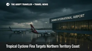
What this means for flights and connections
Darwin International Airport (DRW) remains open at the time of writing, and there is no blanket closure order. However, airlines and air traffic control will be working within a rapidly changing forecast environment, and both domestic and regional operators retain a low threshold for schedule changes when tropical cyclones approach. Expect a mix of retimed departures, aircraft swaps, and rolling delays as carriers try to move aircraft in and out between rain bands, especially on Friday and Saturday when the worst conditions are most likely.
The more fragile parts of the network are regional links that rely on smaller aircraft and short coastal or island airstrips. Communities such as Warruwi, Minjilang, Maningrida, and other Arnhem Land and Tiwi settlements are directly inside the warning and watch zones, and operators may cancel flights outright rather than risk crosswinds, heavy rain, and wet runway conditions. Even where the weather window looks safe for flying, damaged roads, power cuts at terminals, or fuel delivery issues can force short notice cancellations.
For international travelers, the biggest operational risk is not that Darwin will close for days, but that tight same day connections will become unsafe bets. A late arrival from a remote community that was squeezed between rain bands can cause a missed long haul departure to Asia or the Middle East, and rebooking options may be thin in the shoulder season. Anyone planning a chain such as Tiwi Islands or Arnhem Land to Darwin to an overnight international flight in this window should strongly consider adding at least one buffer day in Darwin.
Impact on cruises, tours, and remote stays
Cruise and expedition operators working along the Top End coast, including voyages that call at Darwin, remote islands, and Arnhem Land communities, will be watching Fina's track closely. Even a Category 2 landfall can bring rough seas, heavy swells, and strong crosswinds that make tender operations unsafe and force itineraries to be altered at short notice. Smaller expedition ships and coastal cruise vessels are especially likely to seek sheltered waters or delay embarkation rather than ride out the worst of the weather with passengers on board.
On land, multi day touring that relies on four wheel drive access, boat crossings, or seasonal tracks will also be affected. Heavy rain over the Tiwi Islands, the Cobourg Peninsula, and Arnhem Land can quickly make unsealed roads and crossings impassable, close national park sections, and restrict access to small lodges or cultural sites. Operators may shorten itineraries, move guests into more robust accommodation, or cancel departures where contingency routing is not realistic.
If you are booked on a Top End cruise, small group tour, or remote lodge stay that overlaps the November 21 to 23 window, monitor your operator's alerts and be prepared for changes up to the last 24 hours before departure. Flexible dates or credits are more likely in an active cyclone situation, but policies will vary by company.
How U S travel advisories and alerts fit in
The core security posture for Australia has not changed. The U S State Department continues to list the country at Level 1, exercise normal precautions, which is the lowest tier of its four level system and reflects a generally low crime and security risk. This reinforces that Fina is a time limited weather and infrastructure issue, not a broader security or health shift.
However, the U S Consulate in Melbourne has issued a specific weather alert about Tropical Cyclone Fina, highlighting the potential for strong winds, heavy rain, and possible flooding, and urging American citizens in the region to monitor official Australian sources. That alert explicitly directs travelers to the Bureau of Meteorology and SecureNT, underscoring that local emergency channels, not social media rumor, should be your primary reference for real time decisions.
If you are a U S citizen, enrolling in STEP, the Smart Traveler Enrollment Program, remains a useful way to receive updated messages if the situation worsens or if local conditions change rapidly.
If you are already in the Top End
Travelers who are currently in Darwin or in communities within the warning and watch zones should treat Fina as a serious storm, even if the system remains Category 2 at landfall. The combination of destructive gusts near the core, dangerous storm tides, and heavy tropical rainfall is enough to damage lightweight structures, cut power and communications, and flood low lying areas.
Key steps that align with local advice include
- Following SecureNT and NT Emergency Service instructions about when to secure property, when to move boats, and when to shelter.
- Completing basic cyclone kit preparations, including water, non perishable food, batteries, medicines, and a way to receive updates if the power or mobile network fails.
- Clarifying with your hotel, lodge, or host how they handle cyclones, where guests are expected to shelter, and what their backup power or water arrangements are.
- Avoiding unnecessary road travel during the main impact period, especially on coastal or low lying stretches that can flood quickly.
If your flight is still operating, you should arrive at Darwin International Airport earlier than usual and expect longer queues and more manual handling as airlines deal with rolling schedule changes. If you are told to shelter in place rather than travel to the airport, follow local instructions and contact your airline once you are safe, since most carriers will apply their standard severe weather waivers in a named cyclone.
Planning Top End trips later in the season
For travelers with trips scheduled after this specific event, Fina is a reminder that cyclone season is real in the Top End, even if most years pass without a direct hit on Darwin. Early season storms can be intense, and they tend to move quickly, but the main traveler takeaways are structural rather than alarming.
A few practical planning moves
- Avoid scheduling remote to long haul flight chains inside the heart of cyclone season without at least one overnight buffer in a major city.
- Favor flexible airfares or hotel rates that allow changes without large penalties during November to April.
- Ask expedition and small tour operators how they handle named systems and what credit or refund policies apply if a cyclone forces cancellation.
- Consider travel insurance that explicitly covers weather related disruption, missed connections, and additional accommodation costs, not just medical coverage.
If you are booked into the Top End for the coming weeks and are unsure how Fina might affect your specific itinerary, start by checking the latest Bureau of Meteorology track maps, then cross reference with local government advisories and your airline or cruise line's travel alerts page. If your trip falls outside the November 21 to 23 peak window, the main effect may simply be some residual wet season instability rather than direct cyclone impacts.
Final thoughts
Tropical Cyclone Fina is a relatively small system, but it is moving through unusually warm waters and into a coastline with a long history of cyclone damage and recovery. The combination of an early season landfall, a direct threat to remote communities, and a busy Darwin flight schedule over the coming weekend makes this more than a routine wet season squall line. Travelers who treat official guidance as their baseline, add realistic buffer time into their plans, and stay flexible on routing and dates will be best placed to absorb disruption while staying safe.
If you have critical flights, cruises, or remote transfers in the Top End between November 21 and 23, check your bookings today, build in extra time where you can, and set up alerts from your airline, cruise line, or tour operator so you hear about changes as soon as they are made.
Sources
- Tropical Cyclone Advice, Northern Territory
- Tropical Cyclone Fina to Move Towards the Top End Coast
- Update 1: Tropical Cyclone Fina
- Tropical Cyclone Warning for Cape Don to Warruwi
- Weather Alert, U.S. Consulate General Melbourne
- Australia Travel Advisory
- Tropical Cyclone Fina Intensifies to Category Two and Could Hit NT Coast on Friday
- Tropical Cyclone Fina Forms as the Earliest Named Storm of the Australian Cyclone Season in 12 Years
- Warning to Aussies as Tropical Cyclone Fina Forms off Coast of Northern Territory