Thanksgiving Storm To Snarl Eastern US Travel Nov 25 27
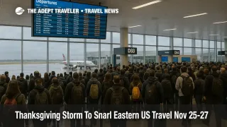
A powerful Thanksgiving storm eastern US flights forecast is now the central planning constraint for anyone traveling between Texas and New England from November 25 through November 27, with forecasters tracking a large system that will bring drenching rain, strong winds, and some snow to the busiest air and road corridors. The National Weather Service outlook and private forecasts show a storm swinging out of the Southwest, crossing Texas and the lower Mississippi Valley, then lifting through the Midwest and into the Northeast during the core pre holiday rush. That timing puts major hubs such as Dallas Fort Worth International Airport (DFW), Hartsfield Jackson Atlanta International Airport (ATL), Chicago O Hare International Airport (ORD), Minneapolis Saint Paul International Airport (MSP), Washington Dulles International Airport (IAD), Philadelphia International Airport (PHL), and Boston Logan International Airport (BOS) in a high risk band for delay stacking rather than routine weather noise.
The Thanksgiving storm eastern US flights pattern means a single multiday system could create compounding delays as it marches from the southern Plains to the Northeast, affecting both outbound and return traffic during one of the densest travel periods of the year.
Storm timeline, November 24 to 27
Forecast centers broadly agree that the initial disturbance will emerge from the Southwest on Sunday November 23, then organize over Texas on Monday November 24, sending heavy rain across the central and southern Plains. Fox Weather and AccuWeather both flag Texas as an early hotspot, with heavy downpours and embedded thunderstorms threatening airport operations around Dallas and Austin, plus stretches of I 20, I 35, and I 45.
By Tuesday November 25, the center of the storm is projected to shift east into the Tennessee Valley and the Southeast, with a swath of heavy rain and thunderstorms from the Gulf Coast through the Ohio Valley. This pattern puts Dallas Fort Worth, George Bush Intercontinental Airport (IAH), William P. Hobby Airport (HOU), and Hartsfield Jackson in the zone for low ceilings, gusty crosswinds, and ground stops, while regional forecasts warn that snow or a wintry mix may develop on the storm's northern flank in parts of the upper Midwest. Meteorologists cited by Economic Times and other outlets expect the heaviest nationwide travel delays on November 25 and 26 as the storm spreads across the central and eastern United States.
On Wednesday November 26, guidance shows colder air pushing into the northern tier as the storm lifts toward the Great Lakes and interior Northeast. In practical terms, that means a high risk of rain and low visibility at major Northeast and mid Atlantic airports, including the New York City trio, Philadelphia, and Boston, while snow becomes more plausible from Minnesota into parts of the Great Lakes belt, impacting Minneapolis Saint Paul and regional connectors. Drivers along I 70, I 80, and I 90 in the Midwest, and I 95 from Washington through New York to Boston, should expect slower speeds, spray, and pockets of fog or mixed precipitation.
Thanksgiving Day itself, Thursday November 27, looks somewhat better but not fully clean. Fox Weather expects roads to be mostly dry in many regions, yet also notes model disagreement over a potential coastal low that could bring rain and snow to parts of the Northeast, plus lingering lake effect snow and gusty winds around the Great Lakes and interior New York. Even if conditions improve overhead, any backlog of aircraft and crews on November 25 and 26 can still produce knock on delays through the holiday afternoon.
Storm timeline, November 24 to 27
AAA projects roughly 81.8 million Americans will travel for Thanksgiving in 2025, a new record that places even more strain on limited runway slots, gate space, and highway capacity. Nearly 90 percent of those travelers will drive, while more than 6 million are expected to fly, with the busiest highway periods on Tuesday and Wednesday afternoons and the Sunday after the holiday. When that level of demand meets a multiday storm that crosses key hubs and corridors in sequence, small schedule disruptions compound quickly into multi hour delays and missed connections, especially for travelers who rely on tight layovers or self connected itineraries.
Unlike a localized thunderstorm day in summer, a Thanksgiving storm that runs from Texas to New England over three days hits both the geographic and temporal choke points of the US system. It strikes just as aircraft and trains are fully booked, and when there is little spare inventory to absorb misconnects or cancellations.
Where delays are most likely
The highest risk zone runs across the eastern two thirds of the country, but the nature of this storm concentrates flight disruption at a handful of key hubs. Dallas Fort Worth, Houston's George Bush Intercontinental, and Hartsfield Jackson Atlanta sit under the early stages of the system, where downpours and possible thunderstorms can trigger ground stops, extended taxi times, and diversions.
As the storm lifts, Chicago O Hare and Minneapolis Saint Paul move into the transition zone where cold air undercuts moisture, raising the odds of snow or mixed precipitation that can force deicing and runway configuration changes. Later, as the cold front and any secondary coastal development reach the Northeast, airports in the New York City region, Philadelphia, Washington, and Boston face a combination of gusty winds, low cloud, and potentially icy conditions inland.
On the roads, interstate corridors that cross the storm track, including I 20 across Texas, I 35 through the Plains, I 40 and I 70 through the Midwest, and I 80, I 90, and I 95 closer to the Great Lakes and the Northeast, are most exposed to downpours, standing water, and sudden visibility drops. Rail operations, particularly along Amtrak's Northeast Corridor and busy regional lines through the Midwest, could also see weather related slow orders or localized flooding delays, although operators are adding cars and crews to handle record demand.
Best days and times to travel
For travelers with flexibility, the safest strategy is to avoid the heart of the storm's evolution on Tuesday November 25 and Wednesday November 26. In broad strokes, Monday November 24 offers better odds in the Midwest and Northeast, although Texas and nearby states will already be dealing with rain. Thanksgiving Day itself often turns out to be a relatively smooth travel day, and current guidance suggests that many regions will at least see improving conditions by midday Thursday, even if the Northeast and Great Lakes still experience scattered showers or snow bands.
Time of day matters almost as much as the date. Early morning departures, when convection is often weaker and delay chains are not yet built up, give better odds of leaving on time. Midafternoon bank peaks, particularly at hubs like Dallas Fort Worth, Atlanta, and Chicago O Hare, are more vulnerable once holding patterns and ground delay programs begin to stack. Red eye departures from the West into early morning arrivals in the East may dodge the worst of the afternoon thunderstorms and evening wind shifts, though this depends on exact storm timing.
Connections, rerouting, and misconnect risk
Because the Thanksgiving storm eastern US flights pattern sweeps east, travelers who connect through the storm zone on both legs are at the highest risk of misconnects. For example, an itinerary that uses Dallas Fort Worth or Atlanta in one direction and New York or Boston in the other could see disruption on both travel days. When booking or rebooking, it is worth trading convenience for resilience by choosing routings through more stable western hubs such as Denver International Airport (DEN), Phoenix Sky Harbor International Airport (PHX), or Salt Lake City International Airport (SLC), which lie outside the main precipitation bullseye in CPC outlooks for November 25 to 29.
Within the storm belt, increase minimum connection times to at least three hours on domestic itineraries and four to five hours on international connections, especially at Chicago O Hare, Minneapolis Saint Paul, Washington Dulles, Philadelphia, and Boston Logan. Avoid self connecting on separate tickets that require reclaiming and rechecking bags, since any delay in the first leg can easily leave you stranded without protection on the second.
Highway and rail planning
AAA and local forecasts expect the heaviest Thanksgiving road traffic on Tuesday and Wednesday afternoons, with Sunday November 30 also flagged as a peak return day. Overlaying the storm track on these peaks, the worst highway conditions are likely Tuesday across Texas, the lower Mississippi Valley, and parts of the Ohio Valley, and Wednesday from the central Great Lakes into the interior Northeast. Drivers should budget extra time for congestion plus weather, plan rest stops away from flood prone low spots or exposed bridges, and avoid overnight departures into snow or mixed precipitation where possible.
On rail, Amtrak and regional operators are increasing capacity on core holiday routes, but storm related slow orders, debris checks, or flood inspections can still stack delays. Travelers should build in margin for late arrivals before time sensitive events and monitor operator alerts closely on mobile apps.
What travelers should do now
In the next 24 to 48 hours, the most valuable move is to check whether your airline, bus line, or rail operator has issued flexible rebooking policies for Thanksgiving week. Many carriers open weather waivers when confidence grows in a large storm, allowing one time changes without fees or fare differences within a defined window. If a waiver appears for your origin, destination, or connecting hub, moving to Monday November 24, Thanksgiving morning, or even the weekend after may save hours of stress.
Travelers who cannot shift dates should harden their plans. That means padding connection times, choosing earlier flights, avoiding the last departure of the day where feasible, and packing essential medications, chargers, and change of clothes in a carry on in case a forced overnight occurs. Drivers should top off fuel earlier in the week, share live locations with family, and keep emergency kits in the car, including warm layers for the northern states likely to see colder post storm air as the polar vortex adjustment develops.
For live, day of coverage of air traffic constraints and reroute options, readers can pair this forecast with our ongoing Flight Delays And Airport Impacts daily reports, which track evolving ground stops, holding patterns, and airport acceptance rates in near real time. For a deeper structural explainer on how weather affects US airline operations and passenger rights, see our guide to managing weather related flight disruptions in the United States.
Sources
- Storms to douse central and eastern US ahead of Thanksgiving targeting key travel hubs, as Polar Vortex looms
- Thanksgiving travel may be slowed by cross country storm next week
- Thanksgiving Weather Update, forecasters warn of widespread travel disruptions
- Thanksgiving week storms expected to impact millions of travelers
- Will winter storms, snow snarl Thanksgiving travel in Ohio
- Maps show Thanksgiving weather outlook for every state
- Record Thanksgiving travel expected across US
- Storms Are Expected To Impact Thanksgiving Travel For Millions