Thanksgiving Storms Threaten U.S. Flights Nov 25-26
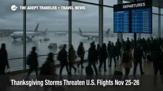
Two Thanksgiving storms threaten U.S. flights Nov 25-26 just as record numbers of people pack the skies and highways for the holiday week. Forecasts now show one system soaking Texas and the southern Plains before sliding into the Ohio and Tennessee Valleys, while a second drives rain and mountain snow through the Pacific Northwest and into parts of the West and Midwest. For travelers, that means the busiest Thanksgiving travel period in fifteen years will also be one of the most weather sensitive, so flight timing, routing choices, and buffers around connections matter more than usual.
In plain terms, the story is no longer just about packed security lines, it is about how Thanksgiving storms could disrupt U.S. flights November 25 to 26 while tens of millions of people try to move at once.
Record Volumes Meet A Stormy Pattern
AAA now projects about 81.8 million people will travel at least 50 miles from home between Tuesday November 25 and Monday December 1, a new Thanksgiving record and roughly 1.6 million more travelers than last year. U.S. airlines, represented by Airlines for America, expect to carry about 2.8 million passengers per day over the same window, with Sunday November 30 and Monday December 1 flagged as the busiest days.
The Federal Aviation Administration says it is preparing to manage more than 360,000 flights across the Thanksgiving period, calling it the busiest holiday air travel stretch in fifteen years, with more than 52,000 flights scheduled for Tuesday November 25 alone. TSA, for its part, plans to screen more than 17.8 million passengers from November 25 through December 2, and expects to see over 3 million flyers on Sunday November 30, one of the highest checkpoint days in its history.
Our earlier coverage in [Thanksgiving Travel Surge To Test TSA Lines Nov. 30][at-tsa] examined those volume pressures in detail, from REAL ID enforcement to record checkpoint days. This update layers the evolving storm forecast on top of that structural crunch and focuses on where and when weather is most likely to tip a crowded system into widespread delays.
How The Two Main Storms Are Lining Up
Meteorologists tracking Thanksgiving week now highlight two overlapping storm systems that will sweep across the country. The first develops over the Southwest and central and southern Plains, spreading heavy rain and thunderstorms across Texas, Oklahoma, Arkansas, and nearby states before pushing into the Mississippi, Ohio, and Tennessee Valleys. The second organizes over the Pacific Northwest, bringing repeated rounds of rain and mountain snow to Washington, Oregon, and parts of northern California, Idaho, and the northern Rockies before energy eventually feeds into the broader central and eastern U.S. pattern.
By Tuesday November 25, guidance from outlets including CNN, FOX Weather, and regional National Weather Service offices shows the heaviest rain shifting from Texas into the Tennessee Valley and the Southeast, raising disruption risk for hubs such as Dallas Fort Worth International Airport (DFW), George Bush Intercontinental Airport (IAH), William P. Hobby Airport (HOU), Hartsfield Jackson Atlanta International Airport (ATL), and Charlotte Douglas International Airport (CLT). At the same time, the Northwest remains unsettled, with Seattle Tacoma International Airport (SEA) and Portland International Airport (PDX) exposed to periods of low ceilings, gusty winds, and mountain snow that can snarl arrivals and departures.
On Wednesday November 26, colder air pushes into the Upper Midwest and Great Lakes, allowing rain to mix with or turn to snow in parts of Minnesota, Wisconsin, Michigan, and interior sections of the Northeast. That raises the stakes at airports such as Chicago O Hare International Airport (ORD), Chicago Midway International Airport (MDW), Detroit Metropolitan Wayne County Airport (DTW), Minneapolis Saint Paul International Airport (MSP), and the New York area hubs, where gusty winds and crosswinds can force spacing on arrival and departure flows even when precipitation is light.
The good news is that Thanksgiving Day itself still looks comparatively calmer for much of the country, with many forecasts pointing to largely dry conditions along the I 95 corridor and across parts of the Midwest, even as lake effect and higher elevation snow remains possible downwind of the Great Lakes and in interior New England. The bigger risks cluster on the core getaway days on either side of the holiday, especially Tuesday and Wednesday for outbound trips and Sunday and Monday for the return.
Airport Risk Bands By Region And Day
Texas and the southern Plains, November 24 to 25. Heavy rain and embedded thunderstorms early in the week will make Monday and Tuesday the highest risk days for flyers using Dallas Fort Worth, Houston Bush, Houston Hobby, Austin Bergstrom International Airport (AUS), and nearby regionals. Low visibility, wet runways, and convective cells can all trigger ground stops and reroutes, and those effects tend to ripple along connecting banks into the Mountain West, Midwest, and East Coast.
Midwest and Great Lakes, November 25 to 27. As energy lifts northeast, Chicago, Detroit, Cleveland, and Minneapolis move into the crosshairs for a mix of rain, wet snow, and strong winds, especially later Tuesday into Wednesday. For travelers, that means high misconnect risk on tight layovers through ORD or MDW, particularly for evening bank connections into smaller regional airports that may see the first cuts when schedules start slipping.
Northeast and Mid Atlantic, November 26 to 27. Forecast confidence is still lower for how intense a potential midweek system will be along the I 95 corridor, but most outlooks agree on at least periods of rain and gusty winds, plus the possibility of mixed precipitation inland. New York's John F. Kennedy International Airport (JFK), LaGuardia Airport (LGA), and Newark Liberty International Airport (EWR), along with Boston Logan International Airport (BOS) and Philadelphia International Airport (PHL), all face elevated delay odds if ceilings drop and crosswinds pick up during peak departure banks.
Pacific Northwest and the West, through the week. A separate storm train in the Northwest keeps SEA and PDX under periodic rain and mountain snow, with spillover impacts for connections into California, the Mountain West, and even Hawaii flights if aircraft and crews fall out of position. Higher elevation corridors in the Sierra Nevada and Rockies also see increased snow risk, which matters both for regional airports and for drivers heading to or from ski areas.
Desert Southwest and the southern tier. Systems passing through the Southwest and southern Plains will periodically drench corridors around Phoenix Sky Harbor International Airport (PHX), Las Vegas Harry Reid International Airport (LAS), and key stretches of I 10 and I 8, creating slick roads and the potential for short term air traffic flow management programs even in places that avoid snow.
What This Means For Your Flight Planning
With weather and volume both peaking, the goal is not perfection, it is reducing your odds of being caught in the worst of the mess. Our ongoing series [Flight Delays And Airport Impacts: November 23, 2025][at-delays] lays out how FAA capacity limits, ATC staffing, and airline recovery patterns shape delay cascades, and those same dynamics will amplify the effect of storms on the busiest days.
If you have not yet locked in flights and can shift dates, prioritizing departures on Monday November 24, Thanksgiving Day itself, or early on Friday November 28 is likely to give you more resilience than a Tuesday afternoon or Wednesday evening departure into the teeth of both storms and crowds. On the return, Sunday November 30 looks unavoidable for many travelers but carries the highest combined risk, so anyone with flexibility should consider Monday evening December 1 or even Tuesday December 2 instead.
Regardless of date, the tactics stay similar. Book the earliest practical flight of the day, when thunderstorms are less developed, airport operations are just ramping up, and there is more slack in the system to recover from delays. Avoid tight domestic connections under two hours and international connections under three hours through the most exposed hubs, especially ORD, ATL, DFW, the New York airports, and SEA. When you can, trade a connection at a storm exposed hub for a slightly longer routing through a less stressed one, even if it costs a bit more or adds an extra hour in the air.
Airlines may post targeted weather waivers as confidence in the storm track grows, particularly for Texas, the Midwest, and select Northeast and Northwest airports. Checking your airline's travel alerts page daily, keeping app notifications on, and preloading alternative flight options in your notes can help you move quickly if free changes open. For families or groups, keeping everyone on the same record locator and ticketed on the same airline rather than splitting across carriers makes reaccommodation simpler when irregular operations hit.
Road Conditions And Driving Strategies
On the roads, the same storms mean different but related problems. Heavy rain along I 10, I 20, I 35, I 40, and I 55 early in the week will slow both local and long haul traffic across Texas, the southern Plains, and parts of the lower Mississippi Valley. Farther north, changing rain to snow on Tuesday night and Wednesday in the Upper Midwest and Great Lakes will raise crash and closure risk on stretches of I 90, I 94, and feeder routes into Chicago, Detroit, Cleveland, and Minneapolis.
AAA and state DOT advisories consistently point to Thanksgiving Day itself as one of the calmest times on the roads, with many people already at their destinations, while the late Tuesday and Wednesday afternoon windows see the worst combination of commuter and holiday traffic. For drivers, that argues for either leaving earlier in the week and building an extra overnight near your destination, or accepting a Thanksgiving morning start in exchange for fewer brake lights and a better chance of beating any lingering bands of rain or snow.
If your itinerary feeds into a major hub, remember that airport access roads, rental car shuttles, and parking decks become the last choke point. Building at least an extra 30 to 60 minutes above normal drive time assumptions, and pre booking parking where possible, can prevent a weather slowed highway from turning into a missed flight even before you reach the terminal.
In short, the new forecast does not guarantee chaos, but it does shift Thanksgiving 2025 from "busy but manageable" toward a week where choices on dates, routes, and buffers will sharply change your odds of a smooth trip.
Sources
- [Nearly 82 Million Americans Projected to Travel over Thanksgiving][1]
- [U.S. airlines expecting record breaking Thanksgiving travel season][2]
- [FAA Expects Busiest Thanksgiving Travel Period in 15 Years][3]
- [GOLDEN AGE OF TRAVEL: TSA is prepared to screen more than 3 million Thanksgiving travelers][4]
- [Storms to douse central and eastern US ahead of Thanksgiving targeting key travel hubs, as Polar Vortex looms][5]
- [Maps Show Snow Risk for Each State Over Thanksgiving 2025 Holidays][6]
- [Winter storm systems could create turbulent Thanksgiving travel in parts of US][7]