Yukon Snowfall Warning Hits Klondike And Haines Roads
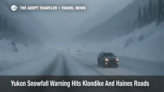
A new Yukon snowfall warning for the South Klondike Highway and Haines Road is turning early season border drives into a serious winter test for road trippers. Environment and Climate Change Canada says a frontal system over the northern Gulf of Alaska is delivering bands of heavy snow to White Pass between Carcross and the Alaska border, and to the Haines Road corridor between Haines Junction and Pleasant Camp, with total accumulation in some passes reaching 20 to 30 centimeters.The result is classic shoulder season whiplash, with interior travelers suddenly facing near mid winter conditions on the only land links between Whitehorse and the ports of Skagway and Haines.
In plain terms, the Yukon snowfall warning for the South Klondike Highway and Haines Road means that anyone planning a cross border drive in this window is exposed to rapidly worsening traction, poor visibility, and the possibility of short notice closures while crews clear drifts and deal with stuck vehicles. The primary travelers affected are self drive visitors running late season Golden Circle itineraries, residents moving between Yukon and coastal Alaska, and winter tour transfers that connect with the Alaska Marine Highway System and regional flights.
Environment Canada's highway bulletins and regional radio partners describe a long period of snowfall focused on two critical mountain corridors. On the South Klondike Highway, the warning highlights heavy snow and blowing snow on the stretch between Carcross and White Pass, with the most intense bands south of Fraser near the summit.On Haines Road, alerts and rebroadcasts point to similar problems between Haines Junction and Pleasant Camp, especially near Chilkat Pass where exposure and elevation combine to amplify drifting.Reporting that draws on 511 Yukon road condition summaries adds that specific kilometers on both routes are seeing loose snow over ice and stretches of fully packed snow, which is enough to turn routine highway speeds into a spinout risk.
Although the heaviest bands are forecast to taper after the core of the weekend, the nature of these passes means that impacts linger. Plows can clear driving lanes relatively quickly, but snow walls constrict shoulders, wind can redeposit powder into ruts, and temperatures dipping well below freezing lock remaining moisture into black ice on shaded curves. That combination turns an otherwise scenic drive above the tree line into a technical winter route that demands experience and a conservative pace.
Where Conditions Differ For Southbound And Northbound Drivers
Southbound drivers leaving Whitehorse for Skagway or Haines begin on relatively gentle interior terrain before committing to long descents through White Pass or Chilkat Pass toward tidewater.The risk profile here shifts over the course of the journey, from dry or packed snow at higher elevations to wetter, slushier surfaces closer to the Alaska side where temperatures may hover nearer freezing or even above. In practice this means that braking distances can change within a few kilometers, so drivers who felt comfortable higher up may suddenly face deep slush, ponding water, and spray that cuts visibility near the coast.
Northbound drivers leaving Haines or Skagway for the Yukon encounter the opposite gradient. The most demanding conditions arrive early as they climb from sea level up into cloud banks and wind exposed summits, where whiteout patches can obscure lane markings and guard rails.Once over the passes, surfaces usually settle into more predictable packed snow and ice on the Yukon side, but fatigue can be a factor after several hours of tension on narrow mountain stretches. Either way, the key takeaway is that drivers must plan fuel, rest, and daylight around the most exposed segments, not simply the total distance.
Rental Cars, Tours, And Local Operator Policies
Most rental fleets based in Whitehorse are on proper winter tires once the season sets in, and operators routinely discourage inexperienced drivers from tackling long mountain passes in marginal weather, even though the South Klondike Highway and Haines Highway are officially open year round.Some providers add winter surcharges, designate specific vehicles for highway use, or reserve the right to cancel or reschedule trips when Environment Canada moves from a simple snowfall outlook to an official warning. Travelers who booked packages that combine vehicles with lodging or activities should read the small print on weather clauses now, while there is still room to shift dates without penalty.
Organized tours and shuttle services that normally link Whitehorse with Skagway or Haines are even more conservative, because they carry groups and must consider both safety and commercial liability. Many Golden Circle tour products already shut down after the main cruise season ends in October, but winter operators that remain active will typically time crossings for midday when plows have already made a pass and when there is enough light to read the road surface.Travelers who are still seeing full day tour options advertised in this window should treat any late cancellations as a signal that conditions are worse than they appear on simple forecast icons.
How To Build Buffers Around The Storm
Yukon authorities stress that winter driving can be risky even outside formal warnings and that anyone heading onto long routes between September and early June should check weather and road conditions before departure, carry extra warm gear, and leave detailed travel plans with a contact.For the South Klondike Highway and Haines Road under this snowfall warning, that baseline advice needs to be upgraded.
First, anyone with flexibility should add at least one full buffer day on either side of the cross border leg, especially if they are trying to meet a specific Alaska Marine Highway sailing or connect with a flight through Erik Nielsen Whitehorse International Airport (YXY) or Juneau International Airport (JNU). Second, travelers should avoid planning critical legs that cross the passes at night or in the early morning, when temperatures are lowest and drifting is more likely to obscure prior plowing. Third, carrying traction aids such as chains is strongly recommended even though Yukon does not mandate chains for passenger vehicles, while remembering that some rental contracts restrict chain use and expect drivers to rely on dedicated winter tires instead.
Using 511 And Weather Services On Both Sides Of The Border
Because these passes straddle an international border and traverse multiple jurisdictions, no single app or website gives a complete operational picture. Drivers should treat 511 Yukon as the primary road condition source for the Canadian side, including live travel advisories, reported surface conditions, and any notes about closures or convoy operations.On the U.S. side, 511 Alaska and local highway information pages supplement those updates with plow priorities and winter driving tips.
For weather, Environment and Climate Change Canada remains the authoritative source for snowfall warnings and highway specific forecasts in Yukon and northern British Columbia, while the U.S. National Weather Service office in Juneau provides complementary alerts for the Alaskan Panhandle, including guidance for the Haines and Klondike corridors.Travelers should cross check both agencies before making a go or no go decision, and remember that in complex terrain conditions can deteriorate faster than forecast, particularly where wind funnels along valleys or over ridgelines.
When Air Or Sea Connections Make More Sense
For some itineraries, the safest response to this Yukon snowfall warning is simply to drop the idea of driving the passes until conditions clearly stabilize. Travelers who planned to link an Alaska cruise or ferry leg with a self drive extension into Yukon can often stitch together an air based alternative, for example by flying from Juneau or another regional hub to Whitehorse rather than driving, or by flipping the route to stay entirely on one side of the border.
Those already on the road should talk directly with cruise lines, ferry agents, or airlines about backup options. That might mean overnighting in Haines, Skagway, Carcross, or Haines Junction and rejoining a trip a day later, rather than pressing on through a pass under marginal conditions. Given how quickly road status can change once a snowfall warning is in place, travelers are usually better served by planning for a deliberate one day delay than by gambling on making a tight window and potentially getting stuck midway without services.
Background: Why These Highways Matter So Much
The South Klondike Highway and Haines Highway form the only continuous road link between the Alaska Panhandle and the Yukon interior, connecting small ports like Skagway and Haines with Whitehorse and, through the Alaska Highway, the rest of the continent.Both roads are officially open all year, but multiple guidebooks and highway logs remind travelers that between roughly mid September and early June, they should treat any long drive as a winter expedition, complete with emergency gear, full fuel tanks, and an expectation that services between junctions will be sparse.
The current snowfall warning is an early signal of that long season. For many residents, this kind of storm is routine and manageable with the right equipment. For visitors who may only have limited winter driving experience and tight vacation schedules, it is a clear indication that plans need to stay flexible. As more travelers mix road trips with cruises, ferries, and flights in the region, we will continue tracking how weather systems like this one affect not only the highways themselves but also the broader network of connections that depend on them.
Sources
- South Klondike Highway highway warnings, Environment and Climate Change Canada
- Haines Road highway warnings, Environment and Climate Change Canada
- Massive Snowstorm Hits Canada, 30cm of Snow Expected, Travel And Tour World
- Rain and Snow Alerts in Effect as Coastal and Northern B.C. Brace for Strong Weather System, Connect FM
- Find Road Conditions On 511 Yukon, Government of Yukon
- Winter Driving Road Safety Awareness, Government of Yukon
- Getting Here, Skagway, Alaska
- Haines Highway Road Log, Bell's Alaska