Verbena Cuts Sea Travel In Central Philippines November 24
Tropical Depression Verbena is now cutting sea travel across parts of the central and southern Philippines, as rough seas, heavy rain, and storm warnings trigger broad no sail orders and scattered flight cancellations on November 24, 2025. The tightest squeeze falls on travelers relying on ferries between Zamboanga del Norte, the Visayas, and northern Mindanao, plus passengers in Southern Visayas ports where dozens of vessels and rolling cargoes are stuck in port. Anyone planning multi island itineraries through Cebu, Bohol, Negros, or nearby islands should assume delays, add at least a day of buffer, and avoid starting new sea legs until the Philippine Coast Guard, PCG, begins to lift bans.
The Verbena sea travel Philippines disruption stems from a compact but rain heavy tropical depression that has already made landfall and is forecast to cross Visayas and northern Palawan before moving out into the West Philippine Sea midweek.
Storm track across Visayas and Palawan
PAGASA, the Philippine weather agency, reports that Verbena developed from a low pressure area east of Mindanao and made landfall over Bayabas, Surigao del Sur, around 1:00 p.m. on November 24, 2025, before its center moved near Jabonga, Agusan del Norte. In its evening severe weather bulletin, PAGASA estimated maximum sustained winds of about 45 kilometers per hour near the center, with gusts to around 70 kilometers per hour, and a west northwest motion of roughly 20 to 25 kilometers per hour.
On the current forecast track, Verbena is expected to traverse the central Philippines between November 24 and 25, crossing Visayas and the northern portion of Palawan, then emerge over the West Philippine Sea on November 26 and continue westward, possibly intensifying over water to at least tropical storm strength. PAGASA and regional disaster agencies warn that 100 to 200 millimeters of rain are likely in parts of Eastern Visayas and northeastern Mindanao, with 50 to 100 millimeters possible across much of Central Visayas, Negros, Bohol, Siquijor, and sections of Mindanao, which raises the risk of flash flooding and landslides along key road and port approaches.
Although Verbena is weaker than the typhoons that hit Luzon earlier in November, the combination of wind, rain, and the northeast monsoon is enough to make coastal seas rough to very rough in many districts, particularly along eastern and central seaboards. PAGASA s sea condition outlook highlights wave heights up to 3.0 to 3.5 meters in several coastal waters and advises mariners of small vessels and motorbancas either not to sail or to use extreme caution, which directly feeds into Coast Guard decisions to suspend voyages.
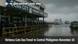
Ferry suspensions and stranded passengers across key corridors
By midafternoon on November 24, multiple PCG districts had imposed temporary suspension orders that turned scattered delays into a broad Verbena sea travel Philippines shutdown across several island corridors. In Zamboanga del Norte, SunStar Zamboanga reports that the Coast Guard suspended all commercial vessel trips from Dapitan City toward the Visayas, including routes to Cebu City and Dumaguete in Negros Oriental, with five shipping firms affected and voyages only allowed to resume when seas improve. The same advisory urged small vessels, motorboats, and fishing boats to stay in port, and told ships already at sea to seek shelter and coordinate closely with the nearest stations.
Farther north, Politiko s Southern Visayas feed cites Coast Guard District Southern Visayas data showing at least 390 passengers stranded across major regional ports, along with 27 vessels and 169 rolling cargo units stuck at berths or staging areas as of early afternoon on November 24. Nine vessels and five motorbancas reportedly took shelter rather than continue into deteriorating seas, while 60 deployable response teams with more than 400 personnel remained on standby for flood or rescue tasks.
Additional reports from government and local media point to related suspensions in other islands. The Philippine News Agency notes sea trip suspensions in Masbate and Sorsogon linked to Verbena, and separate Coast Guard posts reference restrictions for sections of Caraga and Eastern Visayas as gale warnings expand. In practice, that means some classic tourist hops, for example Cebu to Bohol, Cebu to Dumaguete, and inter island routes combining ferries and buses through Negros and Panay, may be off the table for at least part of November 24 and possibly into November 25, depending on how quickly seas calm down.
In Northern Mindanao, Mindanao Gold Star Daily describes how heavy rain around Cagayan de Oro and neighboring provinces prompted class suspensions, while the PCG station in Camiguin temporarily halted all vessel and watercraft voyages, allowing only vessels that need shelter and are not carrying passengers or cargo. Travelers headed for the island s beaches or the ferry link onward to Bohol could find themselves stuck in port or forced to wait for multiple advisories before boarding.
Cebu and regional flight impacts
Cebu is a critical hinge point for the Verbena sea travel Philippines story because it is both a ferry hub and an air hub. Social media advisories from the Cebu Port Authority show multiple cancelled voyages on November 24 due to Verbena, including Trans Asia departures toward Iloilo and ports in Mindanao, with the notice explicitly stamped as valid until further notice. On the air side, Mactan Cebu International Airport (CEB) has issued a public advisory listing several cancelled domestic flights as of early afternoon November 24 as rain bands and gusty winds sweep across Central Visayas.
So far, the pattern resembles earlier November storms, when ferries and some flights were suspended for windows of 24 to 48 hours during Severe Tropical Storm Fung Wong, locally Uwan, but airports like Cebu and Davao reopened quickly once wind thresholds fell and operators caught up with backlogs. However, even a handful of cancellations can cascade into missed connections for travelers who stitched together low cost domestic flights and separate international tickets through Cebu. Delays on approaches, a backlog at check in or security, or a retimed departure can wipe out a tight two hour self connect between an island hop and a long haul flight.
Flights through Francisco Bangoy International Airport (DVO) in Davao are less directly exposed to the center of Verbena, but the AHA Centre and PAGASA forecast maps still paint parts of Mindanao in 50 to 100 millimeter rain bands and gusty conditions through at least November 25, which can translate into weather related spacing, diversions, or minor operational delays. As with Cebu, the risk is less about an outright airport closure and more about timing ripple effects, especially for those on separate tickets or with same day ferry to flight transitions.
Background, how storm and sea travel warnings work
PAGASA uses a Tropical Cyclone Wind Signal, TCWS, system that runs from Signal No. 1 for minimal to minor wind threats up to Signal No. 5 for the strongest typhoons. Under Verbena, large parts of Visayas, Palawan, and northern Mindanao sit under Signal No. 1, which signals strong winds possible within 36 hours, along with enhanced rainfall. The agency also publishes separate heavy rainfall outlooks and gale warnings for coastal waters, with explicit guidance on expected wave heights and which vessel types should avoid sailing.
The Philippine Coast Guard translates those bulletins into practical sea travel bans. When gale warnings reach certain thresholds or when local commanders assess that seas are rough to very rough, they issue maritime safety advisories that suspend voyages for motorbancas and conventional passenger ferries on specific routes. These suspensions are often imposed route by route or district by district, then partially lifted as conditions improve, which explains why some corridors reopen while others remain frozen even within the same region.
NDRRMC, the national disaster agency, has already elevated its alert level from White to Blue in response to Verbena, a move that typically corresponds with heightened monitoring, prepositioning of assets, and closer coordination with local governments and Coast Guard districts. For travelers, this is a signal that while Verbena may not be a top tier typhoon, the operational disruption is real and will be managed cautiously.
Practical routing and rebooking strategies
Anyone currently stranded in Southern Visayas or Northern Mindanao ports should first focus on safety, then on confirming options directly with ferry lines, port authorities, or local agents. Coast Guard advisories usually specify when the next review time will be, which helps in deciding whether to hold a same day connection or to push plans back by at least 24 hours.
If your itinerary involves a chain of ferries, for example Cebu to Bohol to Camiguin, then onward to Mindanao, it is sensible to treat Verbena as a cue to pause that chain until seas clearly improve. Back to back ferry days are particularly risky when one delay or cancellation can force an unplanned overnight and break hotel or tour reservations down the line. Where possible, look for backup flight options through Cebu, Davao, or even Manila, recognizing that seats may be tight and that operators might not offer storm related waivers on every route.
Travelers with international departures out of Mactan Cebu International Airport over the next two days should log into airline apps, check for any change fee waivers, and seriously consider moving early morning departures to later in the week if their schedule permits. Those who must travel should avoid separate domestic segments that arrive less than three or four hours before an onward international flight, particularly if a ferry or long bus ride feeds into that first leg.
For future planning, Verbena sits in the same pattern as earlier November storms that halted ferries and flights during Typhoon Kalmaegi and Severe Tropical Storm Fung Wong. That pattern argues for building one or two buffer days into multi island Philippine itineraries during the late monsoon and early northeast monsoon season, and for avoiding last minute island hops ahead of fixed date events such as weddings, cruises, or long haul flights. As internal Adept Traveler coverage on Fung Wong s ferry shutdowns and on how PAR storm naming works already emphasized, the combination of PAGASA s warnings and Coast Guard no sail orders is predictable in structure, even if exact timing varies from storm to storm.
In the immediate term, the best move for travelers is to keep a close eye on PAGASA, NDRRMC, and PCG channels, confirm every segment before leaving for ports or airports, and assume that Verbena s sea travel restrictions and associated flight bumps will continue in some form until at least November 25, even as the system weakens and moves toward the West Philippine Sea. Planning with that horizon in mind will make it easier to adapt if Verbena intensifies slightly over water or if further coastal flooding complicates road access to ports and airports.
Sources
- PAGASA Severe Weather Bulletin for Tropical Depression Verbena
- PAGASA Tropical Cyclone Bulletin PDF for Verbena
- AHA Centre Flash Update No. 1, Tropical Cyclone Verbena, November 24, 2025
- Philippine News Agency, TD Verbena downs 2 transmission lines in Samar provinces
- SunStar Zamboanga, PCG suspends voyages from Zamboanga to Visayas region
- Politiko Visayas, Southern Visayas passengers, vessels stranded due to Verbena
- Mindanao Gold Star Daily, Classes, sea travel suspended as Verbena drenches region