Cyclone Ditwah Floods Sri Lanka And Asia Travel Routes
Cyclone Ditwah Sri Lanka travel is suddenly more complicated for late November 2025 and early December trips, as deadly floods and landslides cut roads and strain key airports across the region. A rare combination of tropical cyclones and intensified monsoon rains has killed more than 1,300 people across Sri Lanka, Indonesia, Thailand, and Malaysia, and displaced hundreds of thousands. For travelers, the immediate risk is less about closed beaches and more about washed out highways, unstable hillsides, and rural guesthouses that may be unreachable or offline for weeks.
Cyclone Ditwah has turned Sri Lanka's low lying and inland itineraries into high risk, conditional plans, while parallel monsoon floods in Sumatra, southern Thailand, and parts of Malaysia mean any route that leans on secondary roads or local transport now carries a much higher chance of disruption.
Where Flooding Is Hitting Hardest
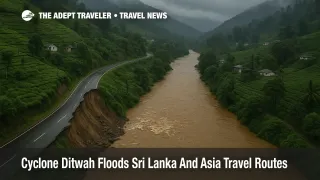
In Sri Lanka, Cyclone Ditwah has produced the country's worst flooding in decades. Situation reports from Sri Lanka's Disaster Management Centre and UN agencies indicate that all 25 districts have been affected, more than a million people have seen their homes or livelihoods disrupted, and at least 410 people are confirmed dead with hundreds still missing as of December 2 2025. Central hill country districts such as Kandy and Badulla have seen entire neighborhoods buried by landslides, while low lying Colombo, Gampaha, and Puttalam have endured deep, prolonged flooding that has knocked out power and water in many areas. [1]
Indonesia's Sumatra island has been hit even harder in absolute numbers. Heavy monsoon rains, amplified by an unusual cyclone in the Strait of Malacca, have triggered catastrophic flooding and landslides across North Sumatra and neighboring provinces. Authorities report at least 700 deaths and hundreds missing, with more than three million people affected and roughly one million evacuees as of early December. Roads into districts such as Tapanuli Tengah and Agam have been cut, and some communities remain reachable only by air or boat. [2]
Southern Thailand has also endured lethal flooding, especially around Hat Yai and other provinces near the Malaysian border. Thai officials report well over one hundred deaths and millions affected across dozens of districts, with some neighborhoods seeing the worst water levels in decades. Malaysia's east coast and parts of the peninsula have faced parallel flooding, with rivers overtopping banks in states such as Kelantan and Terengganu and thousands of people moved into evacuation centers. [3]
Sri Lanka: Hill Country Itineraries And Rural Stays Under Pressure
For Sri Lanka specifically, the government has declared a nationwide state of emergency after Ditwah's passage, and the disaster is being described as the most severe weather crisis since the mid 2000s. UN and government data suggest that close to or more than 1.1 million people have been affected, with tens of thousands sheltering in schools, religious buildings, and temporary camps across the island. Casualties are concentrated in the central hill country, where steep slopes above tea estates and villages have failed after 150 to 500 millimeters of rain in a matter of days. [1][4]
That geography matters for travel. Popular inland routes linking Colombo to Kandy, Nuwara Eliya, Ella, and the tea country rely on roads that thread through narrow valleys and over landslide prone passes. Relief agencies reported that major access routes into Kandy, Badulla, Gampaha, and Anuradhapura were cut or severely restricted at points in late November, and some rural bridges have been washed away or undermined. Even where main highways reopen quickly, many secondary roads that connect homestays, ecolodges, and smaller attractions will take longer to clear and certify. [4]
Sri Lanka's main gateway, Bandaranaike International Airport (CMB), has remained technically open but has seen waves of disruption. Airport authorities and airlines report multiple days of cancellations, long delays, and at least 15 diversions in a 24 hour window as thunderstorms and low cloud made approaches unsafe. Several Colombo bound flights were rerouted to Thiruvananthapuram International Airport (TRV) and other Indian airports, and more than 400 stranded Indian nationals were later repatriated on special services. [5] Travelers should expect schedules at Bandaranaike International to remain fragile until the weather pattern stabilizes and local staff can fully return to work.
Sri Lanka Tourism has activated a 24 hour hotline on 1912, is coordinating with hotels to assist stranded visitors, and has temporarily waived visa extension and overstay fees for tourists who could not depart during the worst of the storm. Officials are also urging airlines to offer more flexible rebooking for affected itineraries. [5][6] That combination of measures makes it easier to stay put safely for a few extra days rather than attempting risky overland transfers when the ground picture is still changing.
Indonesia: North Sumatra And Lake Toba Connections
In Indonesia, the core impact for travelers is currently around North Sumatra, including Medan, Kualanamu International Airport (KNO), and the Lake Toba region. Canada's official travel advisory for Indonesia flags severe flooding and landslides across North Sumatra, especially in mountainous districts and around Lake Toba, noting that roads may be blocked by floodwater and debris and that local authorities can suspend transport services without notice. [7]
Traffic reports from North Sumatra describe long queues and slowing traffic stretching several kilometers toward the exit for Kualanamu International, as inland roads compete with evacuation convoys and fuel supplies are squeezed by damaged infrastructure. [8] In practical terms, this means that flights may still arrive and depart roughly on schedule, but reaching the airport from inland towns can take far longer than normal, and some bus routes feeding Medan or the lake may run an irregular timetable or suspend service entirely.
Meanwhile, an alert from the United States Embassy in Jakarta highlights that Tropical Cyclone Senyar and associated weather systems have caused severe flooding and landslides across Aceh and North Sumatra, with fatalities, missing persons, and significantly damaged infrastructure. The embassy explicitly warns that extreme weather may persist while the cyclone system remains active, and urges travelers to monitor local media, avoid floodwaters, and follow instructions from local authorities. [9]
For visitors planning Lake Toba or other North Sumatra trips in the next couple of weeks, this adds up to a strong argument for either postponing or retooling itineraries so that they are less dependent on long ground transfers and rural lodging.
Southern Thailand And Peninsular Malaysia: Mixed Picture For Beach Trips
Southern Thailand presents a more mixed picture. Flooding has hit parts of Songkhla, Nakhon Si Thammarat, Phatthalung, Trang, Satun, Narathiwat, Yala, and Pattani, and Thailand's own tourism authority lists those provinces as currently affected. Photos from Hat Yai show city streets turned into rivers, stranded residents, and a heavy reliance on tractors and boats to move people and supplies. [3][10]
Hat Yai International Airport (HDY) remains operational, but several airlines, including Thai AirAsia, Thai Lion Air, and Thai VietJet Air, have canceled or consolidated flights on the Bangkok-Hat Yai route during the worst of the flooding. Local authorities estimate that more than a thousand travelers were temporarily stranded at Hat Yai Airport and nearby hotels while floodwaters peaked. The Civil Aviation Authority of Thailand has reminded airlines of their obligations on rebooking and refunds and is monitoring ticket prices to prevent gouging. [3][11]
Thailand's tourism authority stresses that many other destinations, including Phuket, Krabi, and much of the Gulf islands, are operating close to normal, though heavy rain bands can still pass through. Overland travel, however, is heavily disrupted in the deep south, and some secondary roads remain under water or blocked by debris. The United States and other governments have issued weather alerts rather than broad do not travel advisories, but they urge travelers to follow local updates closely and avoid driving through flooded areas. [9][12]
Across the border, Malaysia's disaster agency reports thousands of people displaced into evacuation centers in multiple states after sustained rainfall flooded rivers and triggered landslides. Authorities have advised postponing non essential travel into some flood affected districts in Thailand and Vietnam because of unstable weather, a signal that cross border itineraries combining southern Thailand and northern Peninsular Malaysia should be treated with extra caution in the short term. [3][13]
Transport And Airport Operations Across The Region
Despite the scale of the disaster, the main long haul and regional hubs in the wider area remain open. Suvarnabhumi Airport (BKK) in Bangkok, Kuala Lumpur International Airport (KUL), and Singapore Changi Airport (SIN) continue normal operations, aside from occasional weather related delays. The biggest aviation impacts are concentrated at Bandaranaike International and Hat Yai Airport, along with some smaller domestic fields in Sri Lanka and North Sumatra where runways and access roads have been affected by standing water. [5][11]
Rail and bus networks tell a different story. In Sri Lanka, key rail links through the hill country have faced landslide related closures and slow downs, and even when tracks are cleared, schedules can be erratic as crews and rolling stock are redeployed. In Sumatra and southern Thailand, long distance buses may be diverted, suspended, or slowed significantly by detours around damaged bridges and submerged low points on major highways. Travelers should not assume that a published timetable reflects real world conditions in the days after these kinds of floods.
If you have near term tickets into the region, the safest pattern is to fly into the strongest hub airport that is operating normally, then use airline operated domestic flights or well established ground operators to complete the trip, rather than piecing together informal vans, minibuses, or self drive car rentals in flood affected provinces.
Background: How Cyclone Ditwah Interacts With The Monsoon
Meteorologists describe this event as a rare but increasingly plausible collision between multiple systems. Cyclone Ditwah formed over the Bay of Bengal and swept across Sri Lanka, while another cyclone in the Strait of Malacca and wider monsoon dynamics fed sustained, high intensity rainfall across parts of Sumatra, Thailand, Malaysia, and beyond. A visual analysis by climate reporters notes that even though the global number of cyclones has not spiked, warmer oceans are loading each storm with more moisture, making extreme rainfall and compound flooding more likely. [14]
For travelers, the technical details matter less than the pattern. When a named cyclone intersects with peak or near peak monsoon in a region that has steep terrain, dense river networks, and often unregulated building on floodplains and hillsides, the result is not just coastal damage but interior corridors being cut. That is exactly what has happened in Sri Lanka's hill country and in much of North Sumatra. Trips that were once considered safe in shoulder season now carry a higher baseline risk of landslides, flash floods, and multi day power or water outages.
Insurance, Flexible Bookings, And When To Postpone
Because much of the affected area relies on local guesthouses, small lodges, and independent drivers, the usual advice to "just keep flexible tickets" does not go far enough. Travelers considering Sri Lanka, North Sumatra, or southern Thailand in the next month should look for insurance policies that explicitly cover trip cancellation or interruption because of natural disasters, including floods and landslides, and that reimburse additional accommodation and re routing costs if roads or airports close.
Airlines serving Bandaranaike International and Hat Yai have already issued weather waivers on some dates, allowing date changes without penalty but often still charging any fare difference. Sri Lanka's move to waive visa extensions and overstay penalties for stranded visitors effectively buys extra time to wait out closures, but it does not guarantee that local infrastructure near rural hotels will be usable when waters recede. [5][6] In borderline cases, postponing a complex multi stop, inland heavy itinerary by a few weeks may be safer than trying to force the trip through in early December.
This is also a moment to favor bookable, cancellable options over non refundable promotions. Major hotels and international chains in Colombo, Kandy, and other cities are more likely to have backup generators, water storage, and established emergency procedures than very small rural properties, and they often have clearer policies on refunds and rebooking.
Planning Timelines For Upcoming Trips
For trips in the next seven to ten days, travelers should assume that central Sri Lanka, North Sumatra, and the most flood affected parts of southern Thailand and Peninsular Malaysia remain in response mode. The priority on the ground is rescuing residents, restoring basic services, and clearing critical roads, not accommodating sightseeing detours. Unless you are traveling to a major city or coastal resort that can demonstrate normal operations, the default should be to defer or reroute.
For travel roughly two to four weeks out, it becomes more plausible to keep plans, but only with conditions. This is a reasonable window to favor Colombo plus limited day trips rather than dense multi day circuits through the hill country, or to fly into Bangkok and keep to better drained parts of the south while avoiding the hardest hit districts around Hat Yai. Travelers should use this period to talk with on the ground partners, check that power, water, and road access are stable, and confirm that emergency hotlines and local clinics are functioning.
For trips in early 2026 and beyond, the floods are more a planning lesson than a direct threat. The main takeaway is that climate amplified storms are now an ordinary travel variable in South and Southeast Asia, not rare outliers. Itineraries that build in buffer days, use robust hubs, and rely on providers with strong contingency plans will remain more resilient than bare bones, every day counts schedules. For guidance on building that resilience into future trips, Adept Traveler's explainer on choosing and using travel insurance for weather exposed itineraries is a practical next read. [7]
If you want a sense of how quickly mountain weather can convert a routine trek or scenic drive into a rescue operation, compare this Asian flood sequence with our recent coverage of Patagonia Blizzard Exposes Torres del Paine Trekking Risks and runway closures at Aviador Carlos Campos Airport in Chapelco. The geography is different, but the planning lesson is the same, treat shoulder season and remote area trips as conditional, not guaranteed.
Sources
- Sri Lanka: Tropical Cyclone Ditwah situation updates, UN and partners
- IOM emergency response for Cyclone Ditwah in Sri Lanka
- Asia floods overview, cyclones and monsoon interaction
- Sumatra floods and evacuations coverage
- Southern Thailand flooding and travel conditions update
- Peninsular Malaysia and regional flood situation flash update
- Sri Lanka Tourism emergency hotline and visitor assistance
- Sri Lanka visa and airline flexibility after Cyclone Ditwah
- International travel advice on Indonesia floods
- US Embassy weather alert for North Sumatra