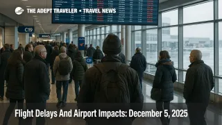
Flight Delays And Airport Impacts: December 5, 2025
Snow, low clouds and gusty winds are driving US flight delays December 5 2025, with the Federal Aviation Administration highlighting Philadelphia, the Washington, D.C., area, Minneapolis Saint Paul and Salt Lake City as key hotspots. The FAA's Daily Air Traffic Report for Friday calls out snowy conditions at Philadelphia International Airport (PHL), Baltimore/Washington International Thurgood Marshall Airport (BWI), Ronald Reagan Washington National Airport (DCA), Washington Dulles International Airport (IAD), Minneapolis Saint Paul International Airport (MSP) and Salt Lake City International Airport (SLC), plus low clouds at Hartsfield Jackson Atlanta International Airport (ATL), Charlotte Douglas International Airport (CLT), Memphis International Airport (MEM), Nashville International Airport (BNA) and Seattle Tacoma International Airport (SEA), and gusty winds at Chicago Midway International Airport (MDW) and Chicago O'Hare International Airport (ORD). Travelers using these hubs should expect longer taxi times, de icing holds and potential ground delay programs.
The core change today is a shift in the main delay risk from the Great Lakes and Upper Midwest earlier this week to a Mid Atlantic snow band and a still active Rockies winter storm that is now sending impacts downstream into Denver, Seattle and South Florida. That pattern sits on top of shutdown driven capacity cuts at dozens of major airports, so even routine winter weather can trigger outsized disruption at the worst affected hubs.
Today's hotspots and delay drivers
The FAA Daily Air Traffic Report is the simplest indicator of where delays are most likely on any given morning. For December 5, it explicitly warns that snow could slow arrivals and departures at Philadelphia, the three major Washington area airports, Minneapolis Saint Paul and Salt Lake City, while low clouds and ceilings add pressure in Atlanta, Charlotte, Memphis, Nashville and Seattle, and strong winds could reduce arrival rates at Chicago O'Hare and Chicago Midway.
On top of the public-facing summary, the FAA's Air Traffic Control System Command Center Operations Plan notes that low ceilings and snow at Philadelphia, the Washington terminals and Salt Lake City are active constraints, and that Atlanta, Charlotte and Nashville are all under low cloud ceilings that tend to produce arrival metering and spacing programs. Seattle is listed with low ceilings and visibility, which is already feeding into ground stop or ground delay planning later in the day.
For travelers, this means that flights which normally operate with short taxi times and direct routings may instead see hold patterns, reroutes and longer queues for takeoff or gate arrival, especially during mid day banks at Philadelphia, the Washington area, Chicago and the mountain hubs.
Ground stops at Detroit and Washington
The most acute operational pinch this morning is not weather but system outages and runway treatment choices. The FAA operations plan lists an active ground stop at Detroit Metropolitan Wayne County Airport (DTW) that applies to Delta Air Lines and its regional partners only, alongside a separate ground stop at Reagan National.
Reuters reports that Delta Air Lines ordered a ground stop for all of its flights at Detroit after a network connectivity issue, telling customers to monitor the Fly Delta app and website while it works on a fix. Because DTW is one of Delta's key hubs, this outage will not only delay local Detroit passengers but also ripple through connections to smaller cities in the Midwest and South and some transatlantic services. Once the stop lifts, there will be a wave of late departures and aircraft out of position, which can keep delays elevated through the afternoon.
In Washington, the operations plan notes that the airport authority at Reagan National does not plan to treat runways and taxiways early in the day, constraining the arrival acceptance rate and prompting a modeled delay program. That is likely to spill pressure onto Dulles and Baltimore/Washington as airlines shuffle flights between the three airports, particularly for shuttle style routes up and down the East Coast. Travelers with tight same day connections across the Washington area should give themselves extra time or, where possible, consolidate on a single airport instead of mixing DCA, IAD and BWI in one itinerary.
Rockies storm keeps pressure on Denver and Salt Lake City
The winter storm that delivered Denver's first major snow of the season earlier this week, with hundreds of flight delays and cancellations on December 3, is not finished yet. Meteorologists expect heavy snow, strong winds and occasional blizzard conditions to continue across parts of Colorado, Wyoming and northern New Mexico through December 5, keeping driving conditions hazardous and making it more difficult for airports to maintain full arrival and departure rates.
The FAA's National Airspace System status page flags a ground stop or delay program as expected at Denver International Airport (DEN) after 500 a.m. Pacific time, with a similar advisory possible for Seattle after 700 a.m. and Palm Beach International Airport (PBI) after 10:00 a.m. as weather and runway work interact. Salt Lake City is already explicitly called out for snow in both the Daily Air Traffic Report and the Operations Plan.
In practical terms, travelers who must connect through Denver or Salt Lake City today should assume longer de icing queues, gate holds and potential aircraft swaps. Evening flights back into the Rockies may be more vulnerable to cancellation if crews and equipment fall significantly behind schedule during the morning and mid day peaks.
Shutdown capacity cuts still limit slack
Even where the weather looks manageable, U.S. airlines are still operating under FAA orders that reduced schedules by up to 10 percent at 40 major airports in November after the longest government shutdown in U.S. history created severe staffing shortages among air traffic controllers.
Lists published by both Reuters and public broadcasters show that many of today's hotspots are also on the capacity reduction list, including the three New York area airports, Chicago O'Hare, Denver, Atlanta, Dallas Fort Worth, Detroit, Boston, Miami and Washington National. While airlines have had several weeks to rework schedules, the reduced baseline means there are fewer spare aircraft and crews to plug holes when weather or outages appear. Recovery from morning disruptions can therefore stretch well into the evening banks, especially at multiplex hubs like Chicago and Atlanta.
For travelers, the practical takeaway is that same day rebooking options may be more limited than in previous winters, particularly on peak days and peak corridors. It is safer to assume that a missed connection will require creative routing or an overnight stay rather than a quick swap to the next departure.
How to plan flights on December 5
For travelers originating at today's flagged airports, early morning departures remain the least risky choice. Flights that leave before snow bands intensify or before low ceilings settle in are more likely to depart close to schedule. Later in the day, monitor the airport's delay status and any active ground delay programs. If arrival or departure averages creep beyond an hour, consider moving nonessential trips to Saturday or Sunday if your fare rules allow.
If a connection through Denver, Chicago, Philadelphia, the Washington area, Minneapolis Saint Paul, Salt Lake City or Seattle is unavoidable, build generous buffers. Three hours for domestic connections and four for itineraries that include a long haul leg is a reasonable floor today, especially where separate tickets or different alliances are involved. Travelers on separate tickets should strongly consider consolidating segments with a single carrier or alliance, even at a modest fare premium, to ensure that missed connections trigger through protection rather than stranded segments.
Long haul passengers arriving from Europe or Asia into Chicago, Washington, Denver or the West Coast should enroll in airline text or app alerts and check in on inbound aircraft status several hours before departure. If the inbound aircraft is already heavily delayed or is being swapped to a different route, same day alternatives may be easier to secure while options are still open.
On the ground, allow extra time for winter driving to and from airports in the Rockies, the Upper Midwest and the Mid Atlantic. Road conditions, not just runway status, will shape whether travelers can realistically make their departure times. Parking shuttles and public transport in snow affected metros may also move more slowly than usual.
For a detailed breakdown of how this week's storm systems have already disrupted flights, with airport by airport metrics, see Adept Traveler's coverage of early December U.S. winter storms and flight delays. That background will help put today's more targeted FAA alerts in context and highlight which hubs are likely to see continued knock on effects through the weekend.
Background: How the FAA Daily Report and Operations Plan work
The FAA Daily Air Traffic Report is a high level snapshot produced by the agency's Command Center each morning that highlights where weather or infrastructure constraints are most likely to slow traffic. It focuses on broad patterns, such as storms, low clouds, visibility and strong winds, and points travelers to official flight status tools.
The Operations Plan is a more technical document aimed at airlines and air traffic managers. It lists specific constraints at each major terminal, active and planned ground stops and ground delay programs, runway and taxiway closures, and any special airspace measures such as rerouted oceanic tracks or flow programs. Together, the two products give the most complete picture of how the National Airspace System is expected to behave on a given day, which is why travelers and advisors who need to make time sensitive decisions should treat them as primary sources.
This approach, focusing on what changed, who is affected and what to do next, follows Adept Traveler's editorial and image style guides for operational travel coverage.
Sources
- FAA Daily Air Traffic Report, December 5, 2025
- FAA ATCSCC Operations Plan Advisory, December 5, 2025
- National Airspace System Status
- Delta Air Lines issues ground stop for its flights at Detroit airport, Reuters
- Weather tracker, Heavy snow blankets parts of US as winter storms hit, The Guardian
- Massive winter storm disrupts Colorado, Wyoming and New Mexico, Travel and Tour World
- DOT and FAA announce temporary 10 percent reduction in flights at 40 major airports
- Which airports are affected by forced US flight reductions, Reuters
- Southwest Airlines lowers full year EBIT forecast as government shutdown hits bookings, Reuters