Bushfires In NSW And Tasmania Disrupt Trains And Trips
Bushfires in New South Wales and Tasmania are now directly disrupting trains, roads and holiday plans, especially for travelers moving between Sydney, the Central Coast and Newcastle, and around Hobart and Tasmania's east coast. On the NSW Central Coast, the Nimbin Road Fire at Koolewong has burned through homes on the slopes above Brisbane Water and pushed smoke across the rail corridor, forcing authorities to suspend all trains on the Central Coast and Newcastle Line between Gosford and Hawkesbury River on December 6, 2025. Further south, fires in the Upper Hunter, near Baerami and Kerrabee, and around Glenlusk and Dolphin Sands in Tasmania are closing local roads, triggering rolling evacuations and reshaping safe driving windows for coastal road trips.
In practical terms, the NSW Tasmania bushfires travel problem is that fires are cutting a key intercity rail link from Sydney and interrupting road access near Hobart and along Tasmania's east coast, so visitors must build detours, longer buffers and possible trip postponements into any near term itinerary.
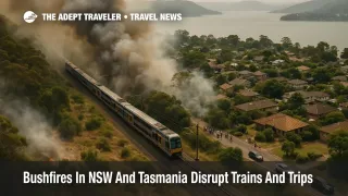
The Nimbin Road Fire, burning across the steep bushland around Koolewong, Phegans Bay and Woy Woy Bay on the NSW Central Coast, has already destroyed or badly damaged at least a dozen homes, with emergency services warning that the final toll could rise as damage assessments continue. Video and aerial images show a dense smoke column towering over Brisbane Water and flames burning within metres of the rail line, conditions that led Sydney Trains to halt services on the Central Coast and Newcastle Line between Gosford and Hawkesbury River and to hold trains on platforms while replacement buses were organised. For travelers, that suspension effectively severs the main public transport spine linking Sydney Central Station with Gosford and Newcastle, which is heavily used by commuters and visitors taking day trips to the Central Coast beaches.
Authorities say the Koolewong fire has burnt more than 120 hectares and, while recent thunderstorms and light rain have allowed the NSW Rural Fire Service, or NSW RFS, to downgrade the alert to Watch and Act in some periods, the fire remains uncontrolled and could flare again if winds shift. Emergency warnings issued on December 6 named streets such as Nimbin Road, Glenrock Parade and Lara Street and told residents to leave immediately if it was safe to head towards Woy Woy, which gives travelers a rough sense of the core impact zone above the rail and road corridor. Even if trains resume in the coming days, short notice halts, speed restrictions and smoke related delays remain likely anywhere the line crosses active firegrounds or recently burned embankments, so same day connections in Sydney should not be planned tightly.
Further northwest, an ongoing bushfire in Goulburn River National Park has burned more than 10,000 hectares around Baerami, Baerami Creek, Widden, Yarrawa and Kerrabee in the Upper Hunter region. This Milsons Gully fire prompted emergency warnings telling people in those small communities that it was too late to leave and that they should shelter inside solid buildings, as the blaze shifted south toward Bylong Valley Way. While this area is less central to mainstream tourism than the Central Coast, it does sit on scenic driving routes used by regional travelers and some self drive visitors exiting the Hunter Valley, so road closures and escort operations along Bylong Valley Way are possible, and anyone planning a loop that uses this back road should have a completely different inland or coastal alternative ready.
Background, how Australian bushfire alerts work
Both New South Wales and Tasmania use a four tier bushfire warning system, typically Advice, Watch and Act, Emergency Warning and sometimes a Reduced Threat or Return with Caution status as fires are contained. Advice signals that a fire is burning but there is no immediate danger to most properties, while Watch and Act means conditions are changing and people should prepare to leave or actively defend. An Emergency Warning, like those issued at times for Koolewong, Glenlusk and Dolphin Sands, means lives and homes are under immediate threat and authorities will often say it is too late to leave safely by road. For travelers, the key is that Watch and Act and Emergency Warning zones are not places to be driving through unless you are following direct instructions from police or fire crews, because smoke, spot fires and sudden roadblocks can trap vehicles.
Tasmania has faced a parallel wave of fires stoked by hot, gusty conditions, with about 30 separate incidents reported on December 4 and 5. A bushfire near Glenlusk, on the edge of Hobart's northern suburbs, triggered an evacuation warning that told residents to leave immediately as the fire approached the area bordered by Brinckmans Road, Faulkners Road and Molesworth Road. That warning has since been downgraded to an Advice level that allows residents to return with caution, but Tasmanian authorities still report ongoing road closures on Glenlusk Road in the affected stretch, which means visitors basing themselves in the Derwent Valley or planning back road drives north of Hobart need to watch for detours and police checkpoints.
On Tasmania's east coast, a separate fire at Dolphin Sands has done even more damage to property and access, destroying or damaging at least 19 homes and shacks, 15 outbuildings and several vehicles on the narrow sand spit that faces Great Oyster Bay. The Tasmania Fire Service and TasALERT have kept the blaze at Watch and Act level into the weekend, and authorities are asking residents not to attempt to return to the area until they are told it is safe. Dolphin Sands Road, the only access road along the spit, has been closed at various points for days, a pattern that should give travelers a concrete picture of how quickly single access coastal communities can become no go zones when fire danger spikes.
The common thread across these NSW and Tasmanian fires is how strongly heat and wind drive operational disruption rather than only the fire size. In New South Wales, daytime temperatures around 40 degrees Celsius and gusty winds have produced fast moving fire fronts and extensive smoke plumes over the Central Coast and Upper Hunter. In Tasmania, wind gusts over 80 kilometres an hour near Hobart grounded firefighting aircraft for parts of the afternoon, limiting aerial water bombing and highlighting how both fire behaviour and aviation can be affected at once. Travelers should be aware that the same weather that encourages beach and hiking plans can turn basic logistics, such as reaching a holiday rental or catching a regional flight, into a high risk bet.
For visitors already in Sydney, the most immediate effect is on rail and road movements up the coast. With the Central Coast and Newcastle Line suspended between Gosford and Hawkesbury River, travelers trying to reach Gosford, Woy Woy or Newcastle should check Sydney Trains and NSW TrainLink updates for replacement buses, and should expect longer travel times, crowding at Sydney Central, Strathfield and Hornsby stations, and fewer options for flexible day trips. Those who have rental cars may find it easier to drive during safer weather windows, but they still need to plan around short notice closures of roads such as Brisbane Water Drive and sections of the Pacific Highway whenever smoke or embers approach the pavement.
In Tasmania, the main gateway airports at Hobart and Launceston have remained open, but pressure is falling on local roads that feed tourist areas. Around Glenlusk, fire conditions and roadblocks can affect detours between Hobart and the Derwent Valley, while the Dolphin Sands fire underscores how quickly a single access holiday community can become isolated, particularly when a narrow road runs along a sand spit with limited escape options. Travelers booking coastal cabins or campgrounds in similar settings should check cancellation policies and consider travel insurance that covers natural hazards, because authorities may keep visitors out of burn zones for days even after the immediate flames are controlled.
For anyone planning to travel through affected regions in the next week, the first step is to treat fire maps, not just weather forecasts, as core planning tools. NSW RFS's Fires Near Me map and app, the Hazards Near Me NSW platform, and Tasmania's fire danger and warning maps on TasALERT and the Tasmania Fire Service website all provide near real time updates on Advice, Watch and Act and Emergency Warning areas. The safest approach is to build itineraries that stay well outside any Watch and Act zones and to design at least two viable alternative routes for each long driving day so you can pivot if an Advice area escalates overnight.
Second, travelers should treat same day flight, ferry or cruise connections as fragile when they depend on passing through fire affected rail or road corridors. Rather than landing in Sydney or Hobart and immediately driving long distances through hot inland valleys, it is safer to schedule an overnight near the gateway city and then head out early in the morning when temperatures and winds are typically lower. Where possible, avoid last bus or last train connections and do not count on evening replacement services if fires force a mid afternoon shutdown, as limited daylight can constrain both road operations and firefighting.
Finally, it is important not to underestimate smoke as a travel factor. Heavy smoke can reduce visibility to the point that speed limits are reduced or convoys are organised behind escort vehicles, and it can also worsen asthma and other respiratory issues in visitors who are otherwise far from the flames. Travelers with known health vulnerabilities should carry inhalers and masks, choose accommodation with good indoor air options and be ready to cancel or shorten hikes and outdoor sightseeing in smoke affected valleys. In some cases, it will be more comfortable and safer to rebase to a different region of Australia for a few days until fire danger ratings ease, rather than pushing ahead with an itinerary that keeps brushing the edge of active firegrounds.
If you need a structural primer for planning Australia trips around seasonal fire risks, see Adept Traveler's earlier coverage of this week's heat and bushfire pattern and broader guides to Australian bushfire season and coastal driving safety, which explain how fire danger ratings, total fire bans and local road closures typically unfold.
Sources
- NSW RFS Major Fire Updates, Nimbin Road Fire, Koolewong
- ABC News, Heatwaves Spread Across Australia, With Emergency Warnings Issued
- ABC News, Dozens Of Property Damaged In The Dolphin Sands Bushfire On Tasmania's East Coast
- NSW Bushfire Emergency Warning, Milsons Gully, Baerami Area
- ABC Emergency, Bushfire Emergency Warning, Glenlusk, Evacuate Now
- TasALERT Bushfire Warnings And Updates
- Adept Traveler, Australia Heatwave And Tasmania Bushfires Travel Impact