BC Highway 4 Closure And Ferries Hit By Atmospheric River
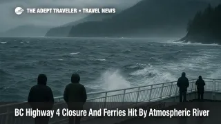
A powerful Pacific storm linked to a long atmospheric river has now shifted from warnings into concrete disruption for British Columbia, closing parts of Highway 4 and forcing BC Ferries to cancel sailings on key Vancouver Island routes. The December 9, 2025 event has brought heavy rain, wet snow on higher passes, and strong winds that are hammering mountain corridors and coastal channels, turning earlier forecasts into real world closures and delays. Travelers bound for Tofino, Ucluelet, Pacific Rim National Park Reserve, and Vancouver Island city breaks should treat plans as provisional, expect rolling cancellations, and be ready to overnight in Vancouver, Victoria, or Nanaimo if links fail.
The BC Highway 4 closure and ferries disruption means the Pacific Northwest atmospheric river travel pattern that Adept Traveler flagged earlier in the week is now directly affecting road and sea links to western Vancouver Island, not just raising abstract risk levels.
Environment and provincial transport bulletins describe a sequence of atmospheric river pulses that peaked around December 9, delivering up to about 250 millimetres of rain in parts of Vancouver Island and the Lower Mainland, along with gusts over 70 kilometres per hour on exposed waters. With soils already saturated and construction zones active along Highway 4, those conditions have triggered debris flows, downed trees, and localized washouts on the stretch between Port Alberni and the west coast communities. The Ministry of Transportation and Infrastructure has responded by closing affected sections for safety while crews clear debris and reassess slopes, leaving Tofino and Ucluelet intermittently cut off from the rest of Vancouver Island.
Highway 4 is the only paved road link between Port Alberni and the Tofino Ucluelet corridor, and in normal conditions it also carries visitor traffic for Pacific Rim National Park Reserve and nearby surf beaches. Construction and base repair projects already underway on this route between July and December 2025 had created regular single lane alternating traffic and 20 to 30 minute delays. The new twist is that the atmospheric river has moved the situation from predictable construction slowdowns into full closures at times, with no simple paved detour. Drivers attempting to reach the west coast should understand that when Highway 4 shuts, they may have to turn back to Port Alberni or wait at controlled checkpoints until crews reopen the road.
On the marine side, BC Ferries has cancelled multiple sailings on core Metro Vancouver to Vancouver Island corridors, notably the Tsawwassen to Swartz Bay, Tsawwassen to Duke Point, and Horseshoe Bay to Departure Bay links, when winds and sea state exceed safe thresholds. Service notices highlight sustained winds above roughly 70 kilometres per hour and low visibility in the Strait of Georgia and adjacent passages as triggers for cancellations, mirroring past storm responses on these routes. While some services continue to operate, alternate sailings fill quickly, leaving vehicle and foot passengers competing for limited space later in the week and pushing some traffic toward smaller, less frequent routes that are also vulnerable to weather.
Air links remain technically open, but the combined impact of road and ferry disruption raises real misconnect risk. Flights into Vancouver International Airport (YVR), Victoria International Airport (YYJ), Nanaimo Airport (YCD), and Comox Valley Airport (YQQ) may operate close to schedule, yet passengers still need surface transport to their final destinations. When Highway 4 is closed or BC Ferries cancels the next crossing, same day self planned hops from a flight to a rental car and west coast lodge can easily unravel. Travelers flying into Vancouver or Victoria without flexible hotel arrangements should be prepared to spend an extra night near the airport or inner harbour rather than attempting to push through marginal driving or crossing windows.
Background, how Highway 4 and Vancouver Island ferries fit together
Highway 4 connects the central island city of Port Alberni to Tofino and Ucluelet, crossing steep terrain and narrow valleys that are sensitive to heavy rain, landslides, and rockfall. In recent years, major slope stabilization work at Kennedy Hill and other sites has reduced some hazards but has also required periodic closures. When an atmospheric river hits, these same cuts and construction zones can become points of failure again, because saturated slopes shed rock and soil faster than crews can safely clear it.
BC Ferries, for its part, is the primary public link between Metro Vancouver and Vancouver Island, carrying tourists, residents, and freight trucks across the Strait of Georgia. The Tsawwassen to Swartz Bay route underpins travel to Victoria and southern Vancouver Island, while the Tsawwassen to Duke Point and Horseshoe Bay to Departure Bay routes serve Nanaimo and the central island highway system that feeds into Highway 4 at Port Alberni. When storms force cancellations on these sailings, supply chains for groceries and fuel also slow, and backup queues can stretch across multiple days of crossings.
How this storm evolved from warning to disruption
Earlier in the week, Adept Traveler covered the Pacific Northwest atmospheric river as a multi day risk event for British Columbia and U.S. Pacific Northwest corridors, focusing on model guidance that showed AR 3 to locally AR 4 intensity and heavy mountain precipitation between December 8 and 11. At that stage, the emphasis was on preparing for possible closures on routes such as the Coquihalla Highway, Highway 1 over Rogers Pass, and other interior passes.
As the core of the moisture plume shifted, the heaviest rain bands and strongest winds lined up more directly with Vancouver Island and the southern coast. Provincial warnings and media reports now describe isolated communities and resort areas on the island as functionally cut off at times by the Highway 4 closure, with BC Ferries simultaneously reducing capacity on main corridors. The result is a compound disruption, where even travelers who planned sensibly around earlier forecasts may find that both their road and sea options narrow on short notice.
Meteorological outlooks from Environment Canada and independent forecasters suggest that while the heaviest surge has passed, additional systems are queued up for December 11 to 12, and soils will remain saturated. That means further debris risk on slopes and continued periods when wind and wave thresholds for BC Ferries are breached, so travelers should not assume that a single day of improvement signals the end of disruption.
Practical planning for Highway 4 and ferry travelers
For visitors already on the west coast of Vancouver Island, the immediate priority is to follow local advisories and conserve flexibility. Hotels and lodges in Tofino, Ucluelet, and Pacific Rim National Park Reserve are accustomed to weather swings, and many will help guests adjust check out times or find extra nights when the highway is closed. When a reopening window appears, drivers should expect single lane traffic controls, reduced speeds, and long queues as built up demand clears. It is wise to leave with a full fuel tank, carry food and water, have warm clothing and blankets in the vehicle, and allow at least several extra hours beyond normal drive times back to Nanaimo or Victoria.
Those still on the mainland or in central Vancouver Island have more options. If your trip is discretionary, the safest choice is to delay west coast drives until after the current atmospheric river sequence and associated slope assessments are complete. If travel is essential, aim for midday windows when road crews have better visibility, avoid night driving on Highway 4 in heavy rain, and consider staying in Port Alberni to wait on fresh updates rather than committing to the full crossing. Travelers without winter rated tires should not attempt the route at all while warnings are in place.
On the sea side, BC Ferries encourages passengers to monitor its Service Notices page and app for route specific cancellations and to treat reservations as schedule guarantees only when conditions remain within operating thresholds. In practice, that means building a fallback plan that might involve a different sailing time, a different route, or an extra night near your departure terminal if the last sailings of the day are pulled. Foot passengers in particular should think about how they will reach their accommodation if late evening sailings are cut and local transit options are reduced.
Air passengers connecting to or from ferries should move away from razor thin same day stacks. For example, instead of landing at Vancouver in the afternoon and booking the last ferry plus a late night drive to Tofino, consider either arriving the day before and overnighting in Metro Vancouver or Victoria, or planning to stay in Nanaimo or Port Alberni before tackling Highway 4 in daylight. Whenever possible, keep your flights and ferries on a single booking through a travel advisor or operator, because this can simplify rebooking when one segment fails.
Longer term lessons for winter trips to Vancouver Island
The December 2025 atmospheric river is another reminder that Vancouver Island's charms come with real infrastructure constraints. A single paved road from Port Alberni to the Pacific Rim, busy ferry corridors that have to respect strict weather thresholds, and steep coastal terrain all combine to make winter trips more fragile than summer ones. Future travelers can reduce stress by avoiding tightly stacked itineraries, keeping emergency kits in vehicles, and leaning on flexible lodging and ticket options even when prices are slightly higher.
For potential visitors still planning 2025 and 2026 travel, pairing this update with Adept Traveler's broader look at Pacific Northwest atmospheric river travel can help set expectations for when and how storms move from background risk into active disruption, and why it is worth paying attention to multi day forecasts rather than just day of headlines.
Sources
- Atmospheric River Storm Closes B.C. Highway 4 and Forces Ferry Cancellations, Disrupting Holiday Travel
- Province of British Columbia, Current Road Advisories and Information
- Province of British Columbia, Use Caution, Be Safe on the South, Central Coasts This Week
- BC Ferries Service Notices
- Pacific Northwest Atmospheric River To Disrupt Travel, Adept Traveler