Pacific Northwest Atmospheric River To Disrupt Travel
A long Pacific moisture plume is now lining up on the Pacific Northwest, turning Pacific Northwest atmospheric river travel plans into a moving target from December 8 to 11, 2025, as heavy rain, rising snow levels, and gusty winds spread across western Washington, Oregon, and southern British Columbia. Forecasts show several rounds of tropical sourced moisture feeding into the same terrain, keeping rain bands and snow in place for days rather than hours. That is a recipe for flooded lowland roads, higher river levels, and tricky driving and rail conditions on the main Vancouver, Seattle, and Portland corridor and the mountain passes that connect coastal cities to the interior.
The Pacific Northwest atmospheric river travel event will bring prolonged heavy precipitation and high snow levels to key U.S. and Canadian corridors, increasing flood, landslide, and closure risk for major highways, rail links, and ferry routes that many winter visitors rely on.
Early December outlooks from the Center for Western Weather and Water Extremes, CW3E, highlight three atmospheric rivers stacking up for landfall between December 3 and 10, with the strongest surge expected between about December 8 and 11. Their ensemble guidance suggests 5 to 10 or more inches of total precipitation on the west facing slopes of the Olympics and Cascades, and a 70 to 80 percent chance that southern coastal Washington reaches at least AR 4 intensity on the five point atmospheric river scale, with a smaller but real chance of AR 5 levels. Independent analysis using National Weather Service, NWS, data reaches similar conclusions, with coastal Washington and northwest Oregon flagged for 200 millimeters of rain and some Cascades slopes potentially near 400 millimeters through midweek.
On the U.S. side of the border, NWS offices and the Weather Prediction Center have issued flood watches for much of western Washington and northwest Oregon, including the Puget Sound lowlands, the lower Columbia region, and portions of northern Idaho and western Montana. Lowlands from roughly Vancouver, Washington, through Seattle and up toward Bellingham may see 2 to 6 inches of rain, while the Olympics, Washington and Oregon Cascades, and some coastal ranges could collect 4 to 10 inches, much of it arriving in less than three days. With soils already wet from previous systems, forecasters are particularly concerned about sharp river rises on basins like the Skagit, Snoqualmie, and Cowlitz, and about shallow landslides on steep bluffs and road cuts.
Snow level is another key part of the pattern. CW3E outlooks and regional briefings point to initially high freezing levels, often above 6,000 feet, which means many passes will see heavy rain and very wet snow at first, rather than light powder, before colder air drops snow levels toward mid and late week. That combination can load slopes quickly, increase avalanche control needs, and send more water into rivers than a typical cold storm. Travelers using I 90 over Snoqualmie Pass, U.S. 2 over Stevens Pass, or I 84 through the Columbia River Gorge should be ready for a mix of hydroplaning conditions, chain requirements, and occasional closures for spinouts or avalanche work.
Southern British Columbia is facing a similar but slightly lower grade event, with the main plume striking Vancouver Island, the Lower Mainland, and parts of the Coast Mountains. The Weather Network forecasts AR 2 to AR 3 intensity over southern British Columbia, enough to deliver another 40 to 80 or more millimeters of rain to the Lower Mainland and eastern Vancouver Island, and 20 to 30 centimeters of fresh snow over higher passes and resort areas. Local coverage and Yahoo summaries stress that this comes on top of earlier wet spells, so smaller rivers and creeks draining into the Fraser Valley and coastal inlets may react quickly.
For drivers, that translates into a patchwork of hazards. British Columbia highways like the Coquihalla, the Trans Canada through Rogers Pass, and sections of Highway 3 toward the Kootenays are all exposed to heavy snow, reduced visibility, and avalanche controls once snow levels drop. Closer to the coast, Highway 1 and Highway 99 can see water pooling, low visibility from spray, and temporary closures where ditches, culverts, or small bridges back up. The BC River Forecast Centre is already flagging the risk of rising rivers and urging residents to monitor updated bulletins and maps as each wave of rain comes through.
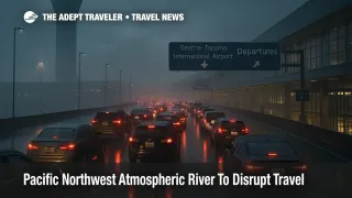
Air travelers will not face a guaranteed meltdown, but they should expect more than the usual winter wobble at the main gateways. Vancouver International Airport (YVR), Seattle Tacoma International Airport (SEA), and Portland International Airport (PDX) are all used to operating in rain, but strong low level winds, low cloud ceilings, and long periods of moderate to heavy precipitation are classic ingredients for approach delays, go arounds, and ground holds. That is especially true for evening banks when arriving international traffic stacks up on top of regional flights that may already be running late from earlier in the day. Travelers booked on tight same day connections, especially those chaining a regional flight into an overnight long haul, should consider moving to earlier feeder flights or shifting the long haul to a different night if airline waivers open up.
Rail and ferry travelers are also exposed. The Amtrak Cascades corridor between Vancouver and Eugene runs close to shorelines, bluffs, and rivers that can see debris, washouts, or minor landslides in prolonged rain, and heavy surf or high water can limit speeds in some sections. VIA Rail services that connect Vancouver with Kamloops and points east share some of the same choke points in the Fraser and Thompson river corridors. On the water, BC Ferries and Washington State Ferries frequently adjust or cancel sailings when strong southerly winds and low visibility combine, particularly on exposed runs like Tsawwassen to Swartz Bay, Horseshoe Bay to Nanaimo, and the San Juan Islands routes. Travelers with rental cars should not assume they can simply turn up for a different sailing; reservations may be mandatory or heavily constrained during storm windows.
For cross border road trips, the key is to treat the Vancouver, Seattle, and Portland triangle as a single weather corridor rather than three isolated cities. If you must drive I 5 between December 8 and 11, allow generous time for slow traffic, minor flooding around on and off ramps, and collisions that temporarily block lanes, and avoid starting long drives late in the day when fatigue and glare from headlights on wet pavement add to the risk. Try to time mountain crossings like Snoqualmie Pass or the Coquihalla for mid morning or early afternoon, when road crews have had time to clear overnight issues and daylight gives you more reaction time. Evening and overnight trips over high passes during the peak of the event are best avoided unless absolutely necessary.
Background, atmospheric rivers and the AR scale are worth a quick recap here. Atmospheric rivers are long, narrow plumes of moisture that transport tropical or subtropical water vapor across thousands of miles, and when they hit mountain ranges like the Coast Mountains and Cascades, that moisture is squeezed out as heavy rain and snow. The widely used AR scale ranks events from AR 1, mostly beneficial, to AR 5, primarily hazardous. An AR 2 to AR 3 event, which is what forecasters expect in much of southern British Columbia, can bring welcome snowpack and reservoir refill but still cause localized flooding and travel issues, while AR 4 or AR 5 events such as the one now possible along parts of the Washington and Oregon coast tend to produce more widespread river flooding, landslides, and infrastructure stress.
If your itinerary is flexible, the simplest move is to shift coastal and mountain travel away from the core Monday night to Wednesday period and aim for windows either before the strongest surge or after rivers and slopes have begun to stabilize. For fixed trips, concentrate your risk in fewer segments. That often means flying nonstop into one hub rather than stringing together separate tickets on discounted flights, moving critical business or family events a day away from likely closure periods, and pre booking refundable hotels near airports or key rail stations in case you need to overnight. Travelers with long multi stop journeys that already pass through storm affected hubs covered in our recent U.S. flight disruption pieces, including U.S. Snowstorm Flight Cancellations: December 8, 2025 and Flight Delays And Airport Impacts: December 8, 2025, should build slack at both ends. For a wider checklist on how to prepare for winter weather disruptions before you leave home, see our Guide To Winter Storm Flight Disruption.
Finally, keep in mind that landslide and river risks often peak after the heaviest rain has fallen. Check the latest NWS river forecasts, BC River Forecast Centre bulletins, and local transportation feeds before committing to long scenic drives or hikes near steep slopes and riverbanks over the days following the main event. If official advice escalates to avoid nonessential travel in certain corridors, especially at night or over specific passes, treat that as a clear signal to rework your plans rather than trying to thread the needle.
Sources
- Major atmospheric river forecast to impact the Pacific Northwest with heavy rain and flooding risk
- CW3E AR Update and Outlook, December 3, 2025
- Powerful Atmospheric River Targets Pacific Northwest
- Weather tracker, atmospheric rivers to bring heavy rain and snow to Pacific north west
- A 7,000 mile atmospheric river is stretching from Philippines to the U.S.
- B.C. targeted with hefty rain, snow totals from intense atmospheric river
- Pacific Northwest bracing for flooding rain, feet of snow as storms line up
- River Forecast Centre, Province of British Columbia
- Watches, Warnings and Advisories, NWS Seattle