South Africa Storm Warnings Hit Holiday Road Trips
Travellers planning December road trips or domestic flights in South Africa now need to treat severe weather as a core part of their holiday planning, not background noise. The South African Weather Service, SAWS, has issued fresh impact based warnings for December 10 and the days ahead, including Yellow Level 2 alerts for severe thunderstorms, heavy rain, hail, and damaging winds across parts of Gauteng, KwaZulu Natal, Limpopo, Mpumalanga, the Free State, North West, and the Northern Cape. These warnings land just as peak school holiday traffic builds, which means self drive safaris, intercity bus trips, and airport transfers into Johannesburg and Durban all face higher disruption and safety risk.
The latest South Africa storm warnings travel pattern means repeated thunderstorm pulses between December 10 and at least December 14 that can close sections of key routes, flood low lying bridges, and slow access to O R Tambo International Airport (JNB), King Shaka International Airport (DUR), and regional hubs feeding park and coast destinations.
Where Storm Warnings Are Tightest This Week
SAWS and local forecast partners now show a broad belt of Yellow Level 2 severe thunderstorm warnings for December 10, stretching over Gauteng, the eastern Free State, eastern North West, the Highveld and escarpment areas of Mpumalanga, and much of Limpopo outside the Lowveld. These alerts highlight the risk of localised flooding of susceptible roads, settlements, and low lying bridges, as well as excessive lightning and both small and large hail.
Further west, complementary bulletins flag severe storms and possible flooding in central and eastern parts of the Northern Cape and adjacent Free State districts, driven by a cut off low and associated systems that are expected to keep thunderstorms firing on multiple days in the second week of December. Forecast summaries for December 9 and 10 already stress partly cloudy, warm to cool conditions with isolated to scattered showers and thundershowers over the central and eastern parts of the country, while the SAWS warnings calendar shows impact based alerts stretching from December 10 through at least December 14.
Regional outlets in Gauteng report that SAWS has singled out the province for persisting chances of severe thunderstorms on December 10, including an estimated 60 percent chance of rain in the afternoon, with the main concerns again being flash flooding, hail, and damaging winds. For holiday travellers, that means corridor risk rather than isolated afternoon showers.
How Repeated Storms Are Hitting Key Corridors
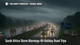
The risk is not theoretical. In early December, a massive storm cell over KwaZulu Natal forced authorities to close the N3 at Town Hill near Pietermaritzburg in both directions after rapid flooding, debris, and poor visibility made the freeway unsafe. Motorists on the N3 between Pietermaritzburg and Durban reported hail, fast rising water, and thick mist, with traffic slowed to a crawl and police urging drivers to avoid flooded stretches and increase following distances.
Those conditions illustrate what a Level 2 or higher thunderstorm warning can translate to on the ground once storm cells intersect with a major transport spine. The N3 remains the main highway linking Johannesburg with Durban and the KwaZulu Natal coast, as well as a key freight and coach route. When storms sit over the KZN midlands, drivers can face a rolling mix of water on the surface, reduced visibility, and scattered debris, any of which can create cascading delays or secondary collisions.
Elsewhere, repeated storms are stressing urban drainage and secondary routes in Gauteng townships, smaller Free State and North West towns, and rural parts of Mpumalanga and Limpopo, where low level bridges and gravel cut throughs are common. Local emergency services have issued multiple reminders not to attempt water crossings on flooded dips or causeways, because road surfaces and erosion damage are often hidden beneath muddy runoff.
Impacts On Johannesburg, Durban, And Park Gateways
For air travellers, the storm belt overlaps directly with the main domestic hub at O R Tambo, the low cost and regional gateway at Lanseria International Airport (HLA), and King Shaka on the Durban side. Earlier in the season, severe thunderstorm days already triggered arrival and departure holds, diversions, and slower ground handling at these airports, with SAWS and Airports Company South Africa cautioning that quick building storm cells can disrupt schedules even when terminals stay open.
Those earlier patterns are now merging with a more sustained December storm phase. Gauteng and Mpumalanga warnings translate into higher odds of approach and departure delays at O R Tambo, Lanseria, and smaller airfields serving park transfers, while KwaZulu Natal and Free State storms can complicate car and bus routes into King Shaka and coastal resorts. Travellers heading for Drakensberg lodges, KwaZulu Natal game reserves, or Kruger National Park via the Highveld corridors need to factor in the risk that a single stalled truck or blocked low water bridge can turn a four hour leg into six or seven.
This new round of warnings also lands on top of non weather infrastructure strains, including the recent closure of the arrivals roadway at O R Tambo and ongoing maintenance and holiday management on the N3 toll route, which will pause major construction from December 11 but still allow for lane restrictions during emergency repairs. Together, that means less slack in the system during a period when many families and tour groups are on the move.
How This Differs From Earlier Storm Alerts
Adept Traveler has already covered South Africa's late spring and early summer storm pattern in pieces such as South Africa Thunderstorms To Disrupt Travel November 29 and South Africa Storm Warnings Hit Travel December 1, which highlighted the initial sequence of Level 2 and Level 4 alerts, airport holds, and hail related road damage.
What has changed in the second week of December is the combination of timing and official messaging. SAWS impact based warnings now line up with a clearly defined holiday window from December 10 onward, municipal and provincial authorities in storm prone regions are explicitly asking residents to delay non essential travel when systems move through, and multiple provinces are under simultaneous thunderstorm risk rather than a single cluster.
For travellers deciding whether to keep or cancel a self drive safari, coastal road trip, or park to city loop, this shifts the question from "might we see a storm" to "how do we manage repeated storms on multiple legs over several days."
Practical Planning For Holiday Road Trips
On storm active days, the safest choice is to keep long distance driving in broad daylight, start earlier than usual, and aim to be at your overnight stop before the most intense afternoon and evening thunderstorm period, especially on the Highveld and in the KZN midlands. While storm timing varies, many of the most disruptive events this season have flared in late afternoon or early evening, when visibility is already falling and traffic is heavy.
Drivers using the N3 between Johannesburg and Durban should treat Pietermaritzburg and its surrounding hills as a decision point. If SAWS or local authorities report severe storms, hail, or closures in the area, the safer call is often to wait it out at a service area, shift to an earlier or later departure on a different day, or overnight up the line rather than pushing into a red or orange radar zone in fading light. Similar logic applies to routes into the Drakensberg and Kruger, where gravel connectors and rural bridges can become traps when water levels rise quickly.
Practical holiday packing should now assume some weather related delays. That means carrying extra water and snacks, a power bank for phones, printed or offline maps in case of signal loss, and enough fuel to handle diversions without dipping too far into reserve tanks. Travellers who are not comfortable driving in heavy rain or poor visibility might be better off booking scheduled transfers with experienced local drivers on the most exposed legs, particularly at night.
Domestic Flights, Buses, And Connection Risk
For flights, the working rule this week should be to add more buffer than you think you need. Travellers driving into O R Tambo, Lanseria, or King Shaka for domestic or regional departures should allow at least one to two extra hours beyond their usual comfort margin, in case of storm related slowdowns on feeder roads or temporary airport ground stops. Anyone booking separate tickets, for example a low cost domestic flight connecting to a long haul international departure, should either move to a single protected ticket or leave a very generous gap between flights to absorb holds or diversions.
Coach and intercity bus passengers on the N3 and other storm exposed routes should expect longer travel times and possible schedule changes. Where possible, choose departures that avoid the most common storm windows, monitor operator updates on social channels, and have overnight options in mind if a leg needs to be broken into two days for safety.
These decisions fit into a broader South Africa planning picture covered in Adept Traveler's South Africa destination guide and recent Gauteng focussed pieces on storms and airport access. Taken together, they point toward a 2025 2026 summer season where travellers can still execute complex itineraries, but only if they respect weather windows, keep routes flexible, and treat local warnings as hard constraints rather than suggestions.
Background: How SAWS Impact Based Warnings Work
SAWS uses an impact based warning system that combines the likelihood of severe weather with the expected consequences on people, infrastructure, and services. Yellow Level 2 thunderstorm warnings, which are prominent in the current pattern, signal that severe storms are likely in places and may lead to localised flooding, hail, strong winds, and dangerous lightning, particularly for low lying bridges, informal settlements, and busy roads. Higher levels raise either the area covered, the confidence in severe outcomes, or both.
For travellers, that means a Yellow Level 2 day is not one to panic about, but it is one to plan around, especially when routes pass through known choke points such as the N3 Town Hill section or urban highways in Gauteng and KwaZulu Natal.
Sources
- South African Weather Service, impact based warnings portal
- SnowReport, South Africa weather forecast 10 December 2025
- The Citizen, Weather forecast 10 December 2025
- News24, Thunderstorms, heavy rain persist in most provinces
- The South African, Severe storms with heavy rain and winds to hit South Africa
- IOL, Pietermaritzburg and Durban lashed by severe storms
- SABC News, Traffic on N3 heavily affected by storm in KZN
- Adept Traveler, South Africa Thunderstorms To Disrupt Travel November 29
- Adept Traveler, South Africa Storm Warnings Hit Travel December 1