Storm Byron Flood Threat For Israel Winter Trips
Storm Byron Israel winter trips now face a live flood threat rather than a distant forecast, as heavy rain, strong winds, and flash flood warnings spread across Tel Aviv, Jerusalem, the Dead Sea area, and Negev routes between December 10 and 12. The Israel Meteorological Service, IMS, and major outlets now report red and orange alerts for 100 to 150 millimetres of rain in many regions, with some forecasts pushing totals toward 200 millimetres on parts of the coastal plain and central highlands. Early bands of Storm Byron are already producing urban flooding, strong gusts, and at least one storm related flight diversion into Ben Gurion Airport, which makes airport access and desert roads the weak points for most itineraries. Travelers now need to rebuild their plans around safe driving windows, backup transfer routes, and city based activities during the peak.
Storm Byron will reshape Israel travel between December 10 and 12 by flooding low lying city streets, stressing drainage systems, and sending dangerous surges through desert wadis that sit next to popular hiking routes and highways. For anyone connecting through Ben Gurion Airport (TLV), driving between Tel Aviv and Jerusalem, or planning Judean Desert and Negev days, this moves the story from a general bad weather warning into an operational test that can strand vehicles, delay airport runs, and close canyon walks at very short notice.
Authorities and meteorologists now describe Byron as Israel's first major winter storm of the season, with IMS warning of "unprecedented" rain in some areas and issuing high level alerts for flooding and flash floods. Forecasts compiled by outlets such as Ynet and Israel Hayom point to peak rainfall from late December 10 through December 11 along the Mediterranean coast, the Shephelah lowlands, and the Jerusalem corridor, followed by slower but still meaningful rain into December 12 as the system weakens but does not fully clear. That timing means the heaviest impacts are likely to land squarely on midweek trips, airport transfers, and desert excursions planned for Thursday.
How The Storm Is Already Affecting Travel
Unlike earlier pieces that could only outline possible impacts, live reports on December 10 already show Storm Byron translating into concrete travel friction. Local coverage describes flooded junctions around Tel Aviv and Haifa, slower traffic on major arteries, and strong crosswinds in coastal and highland zones. At least one flight bound for Israel from Cyprus has diverted around the worst weather, clipping Lebanese airspace before landing at Ben Gurion Airport about thirty minutes late, underlining that air traffic control and crews are actively routing around storm cells.
IMS and civil defence guidance now moves beyond general cautions into specific behavioral advice. Authorities are warning drivers to avoid low underpasses, flood prone junctions, and known trouble spots on urban highways that have ponded badly in past storms, and they are telling residents not to park or shelter in basements or underground garages in districts with a history of flash flooding. Rescue units in the Negev and Judean Desert are on high alert for canyon rescues, and military bases in the south have reportedly released personnel early so they are not trapped behind closed roads once runoff begins.
In Gaza, local authorities and humanitarian outlets warn that the same storm system could worsen already severe conditions in low lying camps and tented areas, where drainage is poor and basic infrastructure is damaged, which adds a humanitarian layer to what is a planning problem for tourists just across the border.
Background, Why Israel's Winter Storms Are So Disruptive
Israel's winter storms often combine three elements that matter for travelers. Heavy Mediterranean rain lands on dense coastal cities, hill roads wind through steep terrain that sheds runoff quickly, and desert wadis that usually appear dry can turn into torrents within minutes. IMS typically issues flash flood warnings whenever a strong system such as Byron lines up over the coast and central hills, because water has very few places to go once urban drainage is overwhelmed and dry channels fill.
Storm Byron also arrives in the wake of recent events that showed how fragile some routes can be. Over the prior weekend, separate heavy rains effectively cut off Eilat for several hours when police shut Highways 12, 40, and 90, blocking all land access while crews dealt with flooded and damaged sections. Ramon Airport (ETM) near Eilat remained technically open, but passengers and residents still had limited options to continue journeys once roads were closed, a pattern that could repeat if Byron triggers similar flash floods on Negev or Arava links.
Which Areas And Routes Are Most At Risk
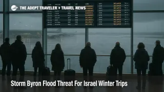
The highest short term risk zones for visitors follow the core IMS and media warnings. The Gush Dan coastal plain around Tel Aviv, Haifa and the northern coast, the Shephelah lowlands, and the Jerusalem hills are all flagged for high rainfall totals and urban flooding. That combination often produces standing water around key junctions, slowed bus routes, and occasional lane closures on roads that feed Ben Gurion Airport and major intercity corridors.
Desert risk is more acute than it looks on a clear morning. Forecasts highlight the Judean Desert, Dead Sea corridors, and the northern Arava as areas with serious flash flood potential once Byron's rain bands move south. Authorities already ban entry to many wadis and marked flood channels during high risk windows, and they may close sections of Highway 90 and connecting roads if water cuts the pavement or undercuts embankments.
For air travelers, the good news is that Ben Gurion Airport and Ramon Airport are expected to keep runways open through most of the storm, with wind and visibility generally inside operating limits. The weak point is the trip to and from the airport. Heavy rain and localized flooding can stretch what is normally a 30 to 45 minute drive into a multi hour slog, and rail services between Tel Aviv, Ben Gurion, and Jerusalem can slow or pause while tracks are checked for ponding and landslides.
How To Reshape Dead Sea And Negev Days
For travelers with flexible itineraries, the safest approach is to reshuffle desert and canyon days away from the Byron peak. If Dead Sea or Judean Desert hikes are slated for December 11, the best move is to swap them with indoor or urban days in Tel Aviv or Jerusalem, then push canyon routes into clearer post storm windows on December 13 or later, when forecasts show more stable conditions.
Tour operators and park authorities may close specific trails and entry roads to famous gorge hikes whenever IMS warnings are active, and they will almost certainly keep visitors out of slots and narrow channels during the rain window. If a tour operator offers to modify a day into a rim or viewpoints only version that avoids wadis, that option is safer than pushing into drainage channels that can suddenly flood. Self drive visitors should never attempt to cross flowing water on desert roads, even if the depth appears shallow, because past incidents show how quickly vehicles can be swept off course.
Along the Dead Sea shores, hotels may close lower level facilities, spas, or parking during intense rain and runoff. That does not cancel a stay outright, but guests should expect some services to be limited, outdoor paths to be slick, and some local roads to be temporarily blocked while debris is cleared.
Managing Airport Transfers And City Plans
Anyone flying into or out of Ben Gurion during the storm window should treat their transfer as the most fragile part of the trip. For departures on December 10 through 12, adding at least one extra hour to normal arrival guidance is prudent, especially for morning and evening banks when commutes, rain, and possible incidents can combine. Where possible, travelers should aim for a rail plus short taxi combination, because trains tend to be more predictable in heavy urban rain than multi lane highways, even if they are running slower than normal.
On arrival, it is wise to have both a primary and backup route from the airport to the city or resort. That might mean preloading offline maps that show alternatives to the Ayalon corridor, confirming whether a hotel offers paid transfers that can be easier to rebook than individual taxis, or arranging an overnight near Ben Gurion if a late landing would push the onward drive into the worst hours of the storm.
Inside Tel Aviv and Jerusalem, Byron is more likely to produce slippery pavements, long taxi waits, and bus diversions than full city shutdowns. Travelers can reduce stress by pivoting toward museums, galleries, and indoor attractions during the peak bands, keeping outdoor walking tours flexible, and accepting that restaurant and show plans may need timing changes if streets flood in the late afternoon or evening.
What Travelers Should Do Now
For visitors already in Israel, the first step is to check local forecasts and IMS alerts, then identify which of their days sit inside the December 10 to 12 peak. High risk activities, including canyon hikes, wadi drives, and long night time road legs, should move out of those windows wherever possible. Next, travelers should pad airport transfers, both by adding time and by mapping alternate routes or modes, so that a flooded underpass or blocked junction does not automatically turn into a missed flight.
Those still booking trips for this week should treat Eilat and Negev heavy driving days as provisional and focus on more flexible city based plans. If avoiding the storm entirely is an option, moving arrivals or departures a few days forward or back will remove most of the operational risk. Travel insurance with strong trip interruption coverage can also help absorb costs if Byron related road closures or flooding force extra hotel nights.
Sources
- Storm Byron prompts red alert as up to 5.9 inches of rain forecast in Israel
- Storm Byron Israel weather forecast floods
- As Storm Byron bears down on Israel, authorities warn of 'unprecedented' rain
- Storm Byron brings floods, strong winds across Israel
- Storm Byron Approaches Israel as Forecasters Warn of Major Flooding
- Flood warnings issued across Israel as Storm Byron unleashes torrential downpours
- Storm Byron Israel Flooding Risk For December Trips
- Storm Byron To Soak Israel And Disrupt December Trips