Storm Bram Aftermath Hits UK, Ireland Transport
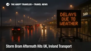
Storm Bram's aftermath is still making the United Kingdom and Ireland a tricky place to move around, even as the main wind event clears. The immediate chaos has eased, but saturated ground, lingering flood impacts, and a new set of weekend rain warnings are keeping rail, roads, flights, and ferries in recovery mode through Monday, December 15, 2025. Travelers heading for airports, ferry ports, and long rail transfers should assume schedules are less resilient than normal, pad connection times, and be ready to reroute at short notice.
That combination, Storm Bram damage plus renewed heavy rain, is what turns this into a route planning problem rather than a single bad day. Put simply, the Storm Bram UK Ireland transport disruption now looks like a multi day reliability slump, not a clean return to normal.
What Changed For Weekend Travel
The Met Office issued new rain warnings on Friday, December 12, 2025, flagging persistent heavy rain into the weekend and early next week across northwest England, parts of Scotland, Northern Ireland, and parts of north Wales. Its guidance highlights the potential for very large totals in the most exposed upland areas, which matters because it increases the odds of fresh flooding, renewed debris on tracks, and longer repair windows for utilities and transport networks.
In Ireland, Met Éireann issued a Status Yellow rain warning covering Clare, Cork, Kerry, Limerick, Donegal, and Connacht from 600 PM on Saturday, December 13, 2025, through 1200 AM on Monday, December 15, 2025, explicitly citing increased flood risk because rivers are already high and ground is saturated. Met Éireann also carried marine warnings for strong winds, a key driver of Irish Sea ferry disruption.
Rail And Road, Why Small Problems Cascade
Rail networks tend to recover in layers after a storm, first restoring basic operations, then clearing speed restrictions, then catching up on displaced crews and rolling stock. National Rail's own disruption note for Storm Bram described the system as largely back to normal after the storm, but "residual disruption" language is a warning sign for travelers, because it is exactly what makes tight itineraries fail when a fresh weather band arrives.
For driving, the practical risk is less about wind at this stage and more about localized flooding and closures on secondary roads that feed major corridors. If you are depending on a single approach road to a ferry port, an airport, or a rail station, a closure can add an hour fast, and sometimes forces a full reroute. In England, the Environment Agency's flood alerts and warnings change frequently, and checking the official flood warning service on the day you drive is one of the most reliable ways to spot whether a river catchment is trending worse.
In Scotland, Traffic Scotland continued to frame the situation as a clean up and recovery effort after Storm Bram, with the system still sensitive to new warnings. That is a strong signal to treat motorway and trunk road journeys, especially in the southwest, as higher variance than normal this weekend.
Ferries, The Most Exposed Mode This Weekend
If you have one mode to be conservative about, make it Irish Sea ferries. Even when sailings operate, strong winds and sea state can trigger port holds, late check in changes, missed rail connections on arrival, and cascading delays into later departures.
The Wales and Ireland corridor has been especially vulnerable during this event. The Welsh Government stated the Port of Holyhead would close for a window on Tuesday, December 9, 2025, due to expected strong winds from Storm Bram, illustrating how quickly operations can stop when conditions cross safety thresholds. Irish Ferries' Dublin and Holyhead sailing updates also show how delays can stack across multiple departures and arrivals, even after the peak wind window passes.
Practical takeaway, if you are booked on Dublin to Holyhead or Holyhead to Dublin, treat your schedule as flexible, and avoid building a same day onward rail ticket that you cannot change. Similar caution applies to other Irish Sea links, including Scotland and Northern Ireland routes, when gales return.
Flights, The Hidden Problem Is Getting To The Airport
Storm driven flight disruption often presents as surface access failure first. Even if your flight is operating, a flooded approach road, a rail delay, or a suspended bus link can be the difference between making the flight and missing it.
For Ireland and Northern Ireland trips, travelers using Dublin Airport (DUB), Belfast International Airport (BFS), and George Best Belfast City Airport (BHD) should plan extra time for the airport leg and keep backup options ready, such as a pre booked car service, a taxi, or an earlier rail departure. For Great Britain, travelers using Manchester Airport (MAN), Liverpool John Lennon Airport (LPL), Glasgow Airport (GLA), and Edinburgh Airport (EDI) should treat Saturday through Monday as higher misconnect risk days when the weather warnings overlap with already stressed networks.
What To Do Now
Start by deciding which leg of your itinerary can fail without breaking the whole trip. For most travelers, that is a ferry crossing, or a rail segment feeding a flight. Build your plan around protecting the most expensive, least flexible booking.
If you must travel this weekend, add buffer aggressively. On mixed mode days, rail to flight, or ferry to rail, plan for a buffer that can absorb multiple hours of delay, or book an overnight near the airport or port. Keep screenshots of operator updates, save receipts, and document rebooking costs, because disruption claims and goodwill refunds often require proof of the timeline.
Also, do not treat "warning ends" as "risk ends." The recovery lag, saturated ground, and ongoing repairs mean the network can keep shedding reliability after the rain stops.
For related context and planning, see our earlier coverage of Storm Bram bringing flood risk to Ireland and UK travel and Storm Bram cleanup leaving UK and Ireland travel fragile. For a structural explainer on disruption related coverage timing, read How the Named-Storm Clause Resets Your Travel Insurance.
Sources
- Rain warnings issued for persistent heavy rain, Met Office
- UK Weather Warnings, Met Office
- Warnings Tomorrow, Met Éireann
- Warnings Sunday, Met Éireann
- Residual disruption following Storm Bram, National Rail
- Flood alerts and warnings, Environment Agency
- Storm Bram travel advice, Traffic Scotland
- Welsh Government statement on closure of Holyhead Port
- Dublin Holyhead sailing updates, Irish Ferries