Winter Storm Warnings In Nova Scotia Hit Highways
Nova Scotia winter storm warnings and snow squall watches remain posted for parts of the province on December 15, 2025, with the highest road risk along the northeastern mainland and western Cape Breton. Drivers moving between Halifax, Nova Scotia, Canada, and the North Shore, plus travelers heading onto Cape Breton for holidays or ski plans, are the most exposed to sudden whiteouts and fast building snow on open highway stretches. The practical move is to pad drive times, avoid tight same day airport and ferry connections, and be ready to pause travel if a squall band crosses your route.
The Nova Scotia winter storm warnings matter for travelers because conditions can swing from manageable to near zero visibility quickly, which is how normal highway trips turn into missed check in windows, late hotel arrivals, and disrupted regional flights.
Nova Scotia Winter Storm Warnings, What Is Affected
Environment Canada's active winter storm warning coverage includes parts of Cape Breton, with Victoria County, Nova Scotia, Canada, under a warning calling for heavy snow and strong winds, including snowfall totals that can reach roughly 25 to 40 cm in western Cape Breton, plus gusts that can approach 90 km per hour and sharply reduced visibility. Inverness County, Mabou and north, Nova Scotia, Canada, is also under a winter storm warning, with heavy snow and wind highlighted as the main travel problem.
On the mainland, Environment Canada has snow squall watches posted for Antigonish County, Nova Scotia, Canada, and Pictou County, Nova Scotia, Canada. The watch language matters because it points to the most disruptive pattern for highway driving, intense bands that can bring sudden whiteouts, quick accumulation, and a fast change from wet pavement to a snow covered lane.
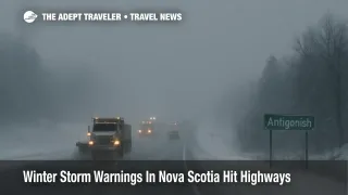
For travelers, the main choke point is the Trans Canada corridor on Highway 104, which is the backbone route for moving between Halifax area lodging, the North Shore, and Cape Breton. When squalls form or pivot near the Northumberland Strait, short segments of the same highway can behave very differently, and a single slow moving crash or closure can force long detours onto slower secondary roads.
Why Snow Squalls Break Itineraries Faster Than Steady Snow
Background A winter storm warning generally signals a broader, longer duration event with hazardous snowfall and wind across a wider area. A snow squall watch is about short duration but intense bursts, where visibility can collapse quickly and drivers encounter suddenly worse conditions than what they saw 10 minutes earlier. For trip planning, that difference is important, steady snow often lets you drive slower and still make progress, while squalls are the kind of event that can force a full stop, especially if you run into a line of vehicles that cannot safely continue.
That is also why airport and ferry knock on effects show up even when a runway or port stays technically open. Deicing queues lengthen when crews are dealing with bursts of heavier snow, and ground transport to terminals becomes less predictable when highways start cycling between clear and whiteout conditions.
Airports And Ferries, Where Plans Can Unravel
Air travelers should watch both Halifax Stanfield International Airport (YHZ) and J.A. Douglas McCurdy Sydney Airport (YQY) for weather driven schedule changes, especially if they are flying on smaller regional aircraft or connecting onward on separate tickets. Even a modest delay can cascade if you are counting on a rental car pickup cutoff, a last bus, or a ferry that does not wait for late arrivals.
Ferry travelers should treat the Northumberland Strait as a real constraint on December 15 and December 16, 2025. Northumberland Ferries canceled crossings between Caribou, Nova Scotia, Canada, and Wood Islands, Prince Edward Island, Canada, for December 15, 2025, due to high wind forecasts, and also canceled early sailings on December 16, 2025. Marine forecasts for the same area have also flagged hazardous wind and sea conditions, which is the kind of setup that can keep service irregular even after a first cancellation posts. If you are instead relying on Marine Atlantic sailings out of North Sydney, Nova Scotia, Canada, check its advisories before committing to the drive to the terminal, because weather can force delays or cancellations that are expensive to absorb at the last minute.
Practical Buffer Rules For Highway 104 And County Level Alerts
For long drives, build the plan around what happens if you have to stop for 30 to 60 minutes. That means starting earlier than you think you need, keeping fuel above half a tank, and avoiding a schedule that requires you to arrive at a check in counter or ferry gate at the last possible minute.
If you must drive Highway 104 through Pictou or Antigonish during the watch window, treat bridges, open farmland stretches, and higher terrain as the places where you are most likely to hit a sudden visibility wall. If a squall hits, the safest choice is often to exit when you can do so calmly and wait for conditions to improve, because squall bands can move through quickly but are most dangerous when drivers try to push forward at highway speed.
For decision support, 511 Nova Scotia is the most useful single dashboard for travelers because it consolidates highway conditions, incidents, cameras, and ferry status, and it is operated by the provincial government. Pair that with the province's highway camera network if you want a quick visual check on whether the route is merely slow or actively dangerous.
Related coverage for travelers building a broader winter disruption plan includes Adept Traveler's prior reporting on Atlantic Canada airline waivers and the site's winter storm topic hub, which can help you compare how waivers and road impacts tend to line up across storms. See Atlantic Canada Winter Storm Airline Waivers Dec 3 2025 and Winter Strom.
Sources
- Environment Canada, Weather Alerts For Antigonish County
- Environment Canada, Weather Alerts For Pictou County
- Environment Canada, Weather Alerts For Victoria County
- Environment Canada, Weather Alerts For Inverness County Mabou And North
- Northumberland Ferries, Travel Advisories
- Environment Canada, Marine Forecast Northumberland Strait
- 511 Nova Scotia
- 511 Nova Scotia, About
- Nova Scotia Public Works, Highway Cameras
- Halifax Stanfield International Airport
- Fly YQY, About
- Marine Atlantic, Sailing Information