California Storm Hits Flights, Highways Through December 25
A multi-day atmospheric river pattern is driving a high impact storm window across California, with flooding risk, damaging winds, and major Sierra snowfall creating real go, no go decisions for both flying and driving statewide. Travelers are most exposed at San Francisco International Airport (SFO) and Los Angeles International Airport (LAX), plus the road corridors that feed them, because wind, low visibility, and water on roadways can break tightly timed itineraries quickly. The practical move is to add buffer, shorten drive legs, and be ready to reroute through alternate airports or pause travel if conditions cross your safety threshold.
The California storm flights and roads outlook is now a statewide operational disruption, not a routine rainy day, because watch and warning timing overlaps peak holiday departures and the storm's second order effects can cascade into missed connections, stranded rental cars, and forced hotel nights.
Northern California's flood risk is not limited to one short burst. The National Weather Service office covering the San Francisco Bay Area and Central Coast says a Flood Watch runs through 10:00 p.m. PT on Friday, December 26, 2025, with rounds of moderate to heavy rain that can overwhelm small creeks, urban drainage, and low lying roads, while wind headlines remain part of the hazard stack. In the Sacramento Valley, the NWS hazard set shows both flooding and wind threats continuing beyond Christmas Day, which matters for anyone driving to reach airports, family destinations, or last minute lodging.
Southern California has the sharper flash flood edge, especially where rain rates spike and where slopes have limited tolerance. NWS Los Angeles and Oxnard issued flash flood warnings and flood advisories on Wednesday, December 24, 2025, including an Interstate 5 corridor segment and adjacent mountain zones, with warning windows running into midday for some areas. That combination, heavy rain plus burn scar sensitivity plus canyon road geometry, is exactly how holiday drives turn into impassable segments, and why travelers should treat "short cuts" through foothills as optional until the pattern clears.
In the Sierra, the aviation problem becomes a highway problem quickly. The NWS Reno office upgraded to a Winter Storm Warning for parts of northeast California and the Tahoe region, effective from 1000 p.m. PT on Tuesday, December 23, 2025, through 1000 a.m. PT on Friday, December 26, 2025, with snow levels dropping to pass level and lake level, shifting the traveler risk from rain to snow, wind, and visibility. Caltrans road conditions already show chain requirements on Interstate 80 over the Sierra, and they also note high wind advisories that can affect major Bay Area bridges, which is a reminder that "getting to the airport" can be the hardest part of the trip.
Who Is Affected
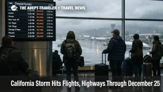
Travelers flying into, out of, or connecting through SFO, plus Oakland International Airport (OAK) and San Jose Mineta International Airport (SJC), are exposed to wind and visibility constraints that can reduce arrival rates and trigger FAA traffic management initiatives. SFO's own alerting notes weather impacts tied to winds and runway configuration, which is the kind of operational change that can turn a normal schedule into rolling delays and missed connections, especially later in the day when aircraft and crews are out of position.
Travelers flying into, out of, or connecting through LAX, plus Hollywood Burbank Airport (BUR), Long Beach Airport (LGB), and San Diego International Airport (SAN), are most exposed during the heavier rain bands and any thunderstorm embedded periods that slow ramp work and increase spacing requirements. Even when the FAA's airport status pages show broadly acceptable averages at a snapshot in time, conditions can deteriorate fast in a strong storm regime, and airline recovery is usually slower than the weather improvement because aircraft rotations have already been disrupted.
Drivers are affected in two distinct ways, Sierra winter travel and lowland flooding. Sierra bound trips, including ski access drives, face chain controls, intermittent closures, and low visibility whiteout conditions, with I 80 and other pass routes acting as the main choke points that can strand vehicles for hours once spinouts begin. Lowland and coastal trips face a different failure mode, standing water, debris, and sudden local closures, particularly on approaches to airports, around underpasses, and on roads near canyons and recent burn scars.
Cruise travelers have a specific timing problem. Same day embarkations out of the Los Angeles area ports or the San Francisco waterfront rely on a chain of dependencies, a flight arriving on time, a roadway transfer that stays open, and a terminal check in cutoff that does not wait for weather delays. When storms force the FAA to meter arrivals and highways to restrict movement, the probability of missing that cutoff rises sharply, and the cost of recovery is usually a last minute hotel plus a rejoin plan.
For related airport delay monitoring during this holiday period, see Flight Delays and Airport Impacts: December 23, 2025 and U.S. Holiday Travel Forecast: Dec 20 To Jan 1.
What Travelers Should Do
If you are traveling on Wednesday, December 24, 2025, or Thursday, December 25, 2025, prioritize buffers over optimism. For flights, protect connections by avoiding tight turns and by favoring earlier departures when you can, because once an airport goes into flow control, delays often stack into the afternoon and evening banks. For driving, shorten legs, stay on primary routes, and treat any mountain pass crossing as a conditional decision that you make only after checking real time road restrictions and weather warnings.
Use clear thresholds for rebooking versus waiting. If your itinerary includes a same day cruise embarkation, a paid tour start, or a nonrefundable lodging check in that requires crossing the Sierra, assume you need a buffer night, unless the forecast and road status both show stable conditions for the entire travel window you will be on the move. If you are on separate airline tickets or you must connect through a hub under wind and rain impacts, shifting to a different day or rerouting to a less constrained airport is often cheaper than trying to "push through" a rolling delay cycle.
Over the next 24 to 72 hours, monitor three feeds and make them agree before you commit. Track National Weather Service watches and warnings for your exact corridor, check Caltrans QuickMap and district road updates for chain controls and closures, and use FAA NAS status or airport specific FAA pages to see whether flow programs are active or forecast. Also watch your airline's travel alert page for any change options, because flexible policies often appear, and disappear, as storms evolve.
How It Works
Atmospheric rivers concentrate deep tropical moisture into a narrow corridor that can produce long duration heavy rain, and in winter that moisture becomes heavy mountain snow once snow levels drop. Operationally, that combination hits travel in layers. First order impacts include reduced airport arrival rates from wind and visibility constraints, ramp slowdowns, runway configuration changes, and roadway flooding or chain controls that limit throughput.
Second order effects are what break itineraries. When the FAA meters arrivals into a hub, flights may be held at origin airports, which delays inbound aircraft that were supposed to operate later departures, and that can cascade into missed connections and crew legality problems. On the ground, when drivers cannot complete one way trips because a pass closes or a corridor floods, rental car fleets stop circulating, which is why holiday storms often show up as "no cars available" even after roads reopen. Hotels then absorb the displacement, especially in gateway cities and in safe stopover towns near closure points, tightening inventory and raising last minute rates.
California emergency managers have prepositioned resources and coordinated shelter and response planning for the late December storm sequence, which is a useful signal that officials expect multi day impacts, not a single afternoon of bad weather.
Sources
- San Francisco Bay Area, CA, National Weather Service
- Bay Area Forecast Discussion, National Weather Service
- NWS Forecast Office Los Angeles, CA
- Flash Flood Warning, NWS Los Angeles and Oxnard
- Reno, NV, National Weather Service
- Caltrans Road Conditions, I 80 Chain Control Update
- Caltrans QuickMap
- National Airspace System Status, FAA
- San Francisco International Airport (SFO) Real Time Status, FAA
- Current Travel Alerts, San Francisco International Airport
- 2025 Late December Storms Prepositioned Resources and Statewide Shelters, Cal OES
- CW3E AR Update, 22 December 2025 Outlook