Flight Delays and Airport Impacts: December 24, 2025
FAA system planning is signaling targeted delay risk across the U.S. network as weather and operational constraints concentrate on West Coast hubs and selected Northeast terminals. Travelers are most exposed on itineraries that touch San Diego International Airport (SAN), San Francisco International Airport (SFO), or Seattle Tacoma International Airport (SEA), where even moderate capacity cuts can ripple into missed connections and late day cancellations. The practical move is to treat tight connections as optional, bias toward earlier departures where possible, and monitor FAA traffic management updates before committing to airport transfers.
The FAA's current planning posture points to rain showers, strong wind, wind shifts, and low ceilings affecting western terminals through the morning and afternoon, with SFO initiatives described as probable through the day based on forecast updates, and SEA and SAN monitored for morning initiatives tied to rain and wind. That matters because arrival metering tends to show up to travelers as gate holds at origin airports, and then uneven arrival waves that compress downstream schedules later in the day.
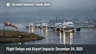
As of the latest FAA NAS status event snapshot, the most concrete, traveler facing constraint is an active ground delay program into San Diego tied to runway construction. The program window runs from 900 a.m. to 759 p.m. Pacific Time on December 24 [1700Z on December 24 through 0359Z on December 25], with average delay around 63 minutes and a listed maximum delay of 115 minutes at publication time.
Who Is Affected
Travelers starting, ending, or connecting through San Diego are the most directly exposed today because a ground delay program meters arrivals by assigning controlled departure times across a wide set of origin airports. If you are inbound to San Diego on a hub connection, your first flight can look on time until close to boarding, then slip once your controlled time is issued, which can break tight connections and late afternoon ground transfers.
West Coast travelers touching San Francisco and Seattle should plan for higher uncertainty even when your specific flight shows as on time early in the morning. FAA planning describes SFO initiatives as probable, and it also flags possible initiatives for SEA, which is the combination that often creates rolling disruption because aircraft and crews shuttle between these airports and other hubs all day. When the morning bank runs late, airlines lose slack, and the problem shifts from simple delays into missed turns, crew duty limit pressure, and more aggressive rebooking later in the afternoon.
Northeast travelers, especially those connecting through Newark Liberty International Airport (EWR) or moving through New York City area airspace, should watch for low ceiling and low visibility constraints, with FAA planning listing possible initiatives for EWR later in the day. Boston Logan International Airport (BOS) also shows up as a possible initiative risk in the FAA planning, and when BOS and the New York complex are constrained at the same time, the disruption spreads across the corridor, not just one airport.
Florida travelers heading into Miami and nearby South Florida airports should expect routing friction to be a quiet but real risk factor today. FAA reroute and flow constraint advisories are active for the South Florida airspace complex, which can add route distance, sequencing, and holding pressure, especially during peak holiday arrival pushes.
What Travelers Should Do
If you are flying today, move your decision point earlier than normal. Check your inbound aircraft, then check the FAA posture for your destination and any connection hub, especially if you touch San Diego, San Francisco, or Seattle, because these programs can flip from "possible" to "active" quickly and the delay you experience may be assigned at the departure gate, not in the air. If you are checking a bag or you have a critical same day transfer, add buffer before you leave home so a late arrival does not force you into the most expensive last minute options.
Use a hard threshold for rebooking versus waiting. If your itinerary depends on a short hub connection and an assigned delay pushes you past your last realistic protected connection bank, rebook immediately while inventory still exists. If your delay is moderate and you still have multiple protected options later the same day, waiting can be rational, but only if you can absorb a gate change, a longer taxi out, and the possibility that a second downstream delay hits your connection bank after you land.
Over the next 24 to 72 hours, monitor whether West Coast wind and ceiling constraints persist into the next morning bank, and whether Northeast low visibility risks become active programs. Multi day repetition is what turns "annoying delays" into "cancellations and misconnect waves," because aircraft rotations lose slack and crews time out, forcing airlines to protect the next day's schedule by trimming late evening flights.
Background
The FAA Air Traffic Control System Command Center uses traffic management programs to keep arrival flows safe when an airport's acceptance rate drops, whether from weather, volume, or runway configuration limits. A ground delay program meters arrivals by assigning controlled departure times so flights wait at their origin airports rather than stacking in airborne holding, which is why a delay at one airport can show up to you as a late departure from somewhere else.
The disruption propagates in layers. First order effects occur at the constrained airport as arrival rates drop and arrival sequences stretch, which pushes arriving aircraft late into gates and delays the next departure. Second order effects spread across connections and crew flow because the same aircraft and crews are scheduled to operate multiple legs, often crossing regions, so a metered West Coast hub can create late inbound equipment at inland hubs, then missed connection banks in the afternoon. A third layer shows up off the aircraft, where late arrivals push travelers into after hours rental car and shuttle friction, and it can compress hotel check in windows or trigger unplanned overnight stays near the airport.
For continuity on how these daily FAA planning signals can evolve into active programs, see Flight Delays and Airport Impacts: December 23, 2025 and U.S. Airport Delays, Ground Stops, December 22, 2025.